

Storms Advancing Through Alabama
An all new edition of the ABC 33/40 Weather Xtreme video is available in the player on the right sidebar of the blog. You can subscribe to the Weather Xtreme video on iTunes by clicking here.
RADAR CHECK: The line of storms is making steady progress through Northwest Alabama early this morning, and as expected the storms are showing a slow weakening trend. Winds did gust to 50 mph at Hamilton in Marion County as the storms moved through, and there were reports of a few trees down in Lamar County. But, generally speaking, winds have been in the 30-40 mph range with few damage reports.
The storms will end from west to east this afternoon, and cooler and drier air blows into Alabama tonight.
SUNNY SATURDAY: We will enjoy a one day break from the rain tomorrow… expect a good supply of sunshine with a high in the mid 60s. Clouds return quickly tomorrow night, however.
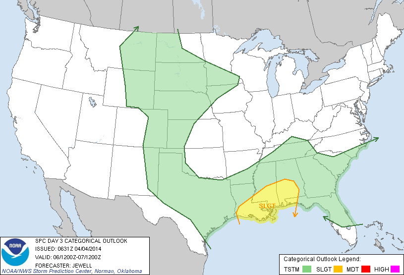
MORE RAIN: Rain moves back into Alabama Sunday; it will spread northward during the day, and by Sunday afternoon rain is likely statewide as a surface low forms on the Louisiana coast.
This low will move to a point between Memphis and Nashville by Monday morning, and with very good dynamic support it will bring the risk of severe weather to parts of our state Sunday night into early Monday morning.
The primary limiting factor in severe weather with this event will be the lack of instability; the better chance of seeing decent surface based instability will be over the southern half of Alabama, and this is where SPC has defined the standard “slight risk” of severe weather…
Projected bulk shear values are very high, and the low level jet will be screaming overnight Sunday night into early Monday, so where we do see surface based instability, all modes of severe weather will be possible, including tornadoes.
For now it looks like the primary severe weather risk will come along and south of a line from Tuscaloosa to Montgomery to Dothan, and generally between 10:00 p.m. Sunday and 10:00 a.m. Monday. We will be able to better specific the risk later today and tomorrow.
We should also note that some flooding issues are possible; rain totals of 2 to 3 inches are expected before the rain moves out during the midday hours Monday.
REST OF NEXT WEEK: A deep upper trough will move over Alabama Tuesday; the day will be mostly cloudy and cool with potential for some light rain. Then, the rest of the week will be cool and dry.
Still some concern for a late season frost… mainly Thursday morning… over North and Central Alabama. Growers will need to closely monitor temperature forecasts; see the Weather Xtreme video for the maps, graphics, and more details.
WEATHER BRAINS: Don’t forget you can listen to our weekly 90 minute netcast anytime on the web, or on iTunes. This is the show all about weather featuring many familiar voices, including our meteorologists here at ABC 33/40.
CONNECT: You can find me on all of the major social networks…
Facebook
Twitter
Google Plus
Instagram
Busy day ahead… I am speaking at the Building Owner’s and Manager’s Association regional meeting in Birmingham this morning, and then I have a weather program at Erwin Intermediate School in Center Point. Tonight I will be speaking in Midfield at the dedication of their new community tornado shelter. Look for the next Weather Xtreme video here by 4:00 or so this afternoon… enjoy the day!
Category: Alabama's Weather
About the Author (Author Profile)
James Spann is one of the most recognized and trusted television meteorologists in the industry. He holds the AMS CCM designation and television seals from the AMS and NWA. He is a past winner of the Broadcast Meteorologist of the Year from both professional organizations.Subscribe
If you enjoyed this article, subscribe to receive more just like it.


