

Late Night Look at the Severe Weather Threat for Alabama
There is a threat of severe weather this afternoon over South Alabama, spreading northward into West Central Alabama south of US-82 this evening and over areas south of US-78 and west of I-65 during the overnight. The SPC has the southwestern quarter of Alabama in a “slight” risk for severe weather, their standard severe weather forecast.
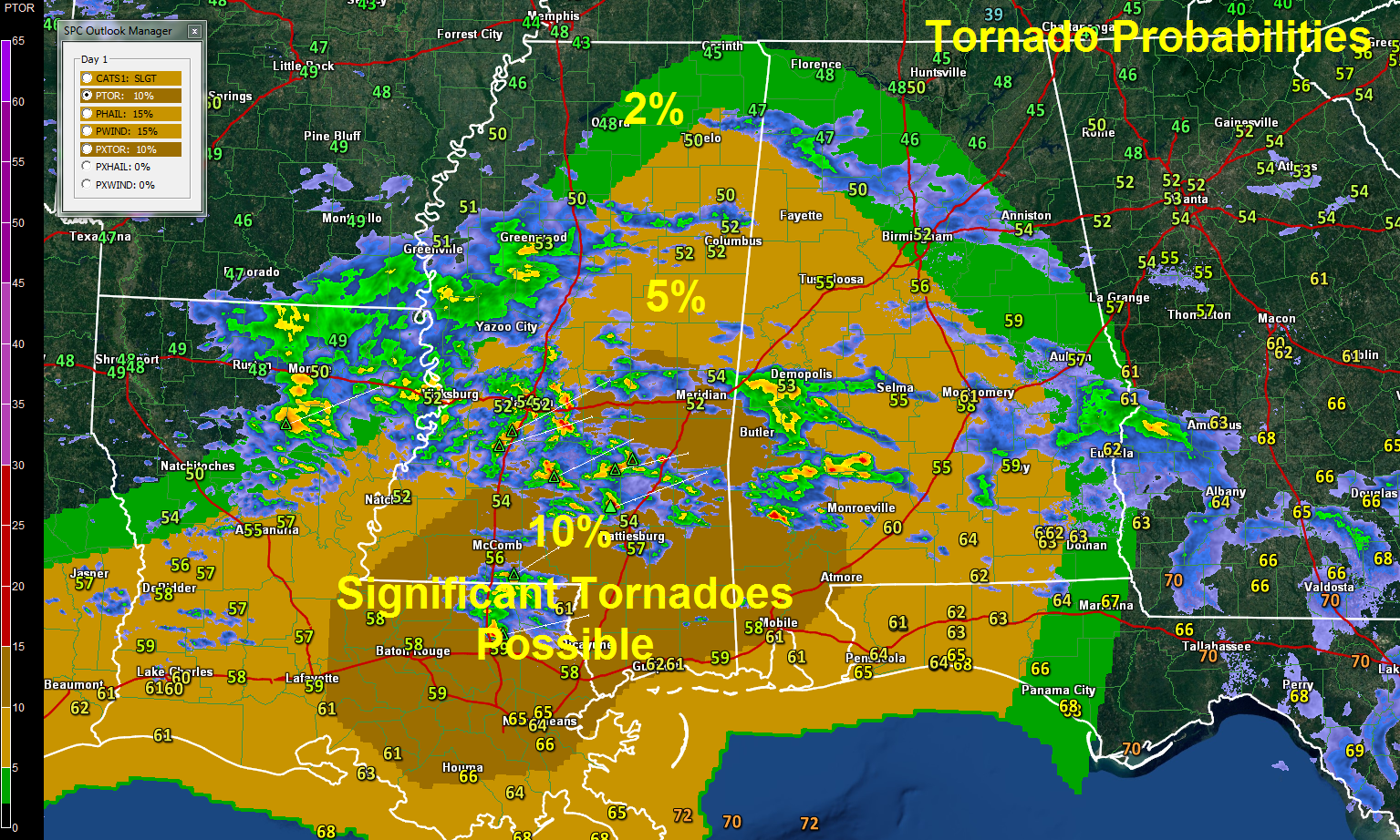
Thunderstorms will intensify through the day along the Gulf Coast across southern Louisiana, southern Mississippi and southwestern Alabama. Damaging winds and tornadoes will become a problem this afternoon over this region, including New Orleans, Lafayette, Hattiesburg, Meridian, Mobile and Jackson, Alabama. The SPC has a 10% tornado probability (chance of one within 25 miles of a point) in this area, including a hatched area, which indicates a likelihood of significant (EF2 or greater tornadoes.) Here are the tornado probabilities. The slight risk outlook corresponds to the 5% tornado threat area.
Click to enlarge
The threat of damaging winds and tornadoes will lift northward with the warmth, moisture and instability Sunday evening, overspreading West and Central Alabama. Accordingly, the SPC has their standard basic severe weather risk in place for this afternoon and tonight south and west of a line from Hamilton to Jasper to Hoover to Rockford to Tuskegee to Ozark and back to Destin.
CAPE values will rapidly increase to 500-750 j/kg as far north as US-82 by 1-2 a.m. and this moderate instability will spread up to areas south of US-78 and east of I-65 before sunrise. So it appears there will be the requisite instability. And wind shear will be in good supply as well, with 0-1 km helicity values reaching 200 m2/s2 by evening. This combination could produce tornadoes and damaging winds in the risk area. The greatest threat will be south of a line from Livingston to Camden to Atmore and back around to Mobile.
WATCH THE WARM FRONT: Wind shear will be enhanced along the northward moving warm front during the late afternoon and evening hours. We will have to watch storms along this boundary for the threat of tornadoes as well.
SEVERE WEATHER THREAT SHIFTS EASTWARD: Monday morning, the threat of severe weather will shift eastward over southeastern and East Central Alabama ahead of the cold front that will move eastward. The bulk of the rainfall should be east of I-65 by late morning with just a few lingering showers into the afternoon.
DON’T FORGET: There is a flash flood watch that will go into effect at 10 a.m. this morning for all of Central Alabama.
Category: Alabama's Weather, Severe Weather
About the Author (Author Profile)
Bill Murray is the President of The Weather Factory. He is the site's official weather historian and a weekend forecaster. He also anchors the site's severe weather coverage. Bill Murray is the proud holder of National Weather Association Digital Seal #0001 @wxhistorianSubscribe
If you enjoyed this article, subscribe to receive more just like it.


