

Slight Risk Area Expanded Slightly
On the 7:30 a.m. CDT update to the Day One Severe Weather Outlook, the SPC slightly expanded the Slight Risk area, moving it north of Birmingham. Here is a sneak peek at the latest severe weather info for this afternoon’s forecast package.
TIS THE SEASON: Alabama is a climatologically favored place for severe weather the first week of April. On this map from the SPC, you can see where significant tornadoes are most likely across the nation during the first week of April.
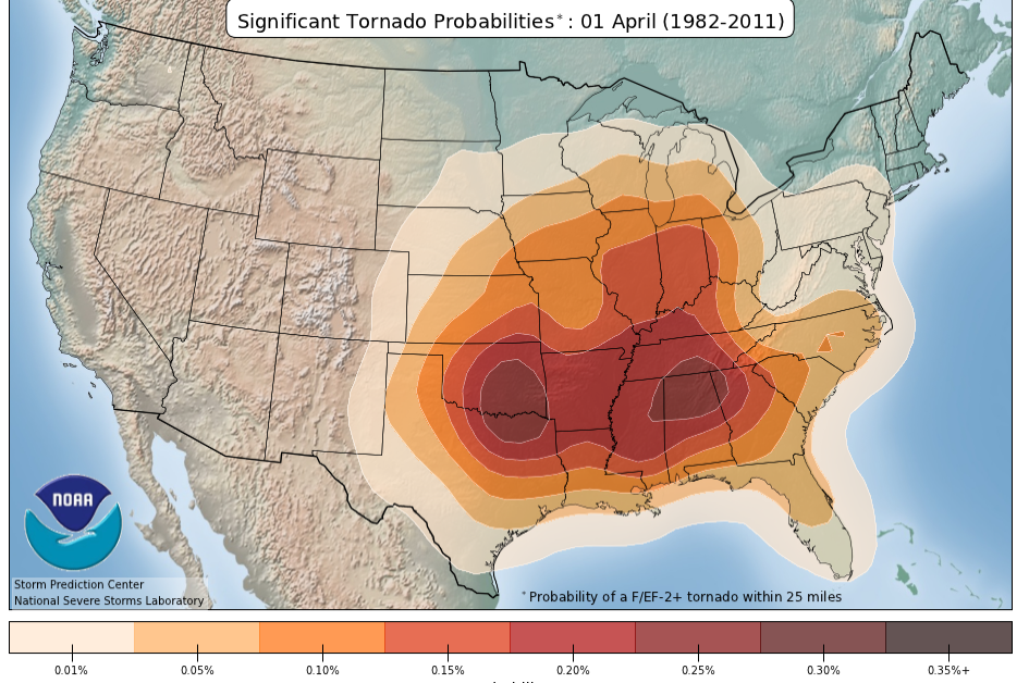
There is a bulls eye over North Alabama the first week of April where the probabilities are highest for having a significant tornado (EF2 or greater). This peak period actually blooms over North Alabama around March the 11th and expands until April 22nd, when it begins to shrink and consolidate with a similar maximum over Oklahoma and northern Texas. The Sooner State becomes the sweepstakes winter in the significant tornado department. The maximum sets up over Oklahoma and North Texas by April 15th. It peaks at about a probability of over 0.35% and expands, but gradually lessens and shifts north toward Iowa and Nebraska by the middle of June.
FORTUNATELY even though this is prime season for significant tornadoes in our area, the probability that one will occur within 25 miles of any place in the maximum area is only 0.25%. Not 25%, but 0.25 percent, so well less than 1%.
UNFORTUNATELY: Today is one of those days when there may well be a few significant tornadoes across the state. The best chance of a significant tornado is over southwestern parts of the area, south and west of a line from Cuba to Pine Hill to Atmore, except for southern Mobile and Baldwin Counties. But there is a decent chance (5%) that there will be a tornado within 25 miles of you if you live north of the significant risk area, but south of the official Slight risk issued by the SPC. The northern boundary of the 5% tornado probability and slight risk area extends from near Hamilton to Carbon Hill to Hoover to Tuskegee. We will have to watch out for damaging winds as well, especially late tonight as the threat transitions from discrete supercells to a squall line.
SECRET WEAPON: You say it doesn’t feel like severe weather out there today. But the secret weapon of severe weather outbreaks will be brandished by our system tonight: the low level jet. As a strong upper level trough progresses eastward, surface low pressure near the Texas coast will move northeast and intensify this afternoon and evening. By 10 p.m., it will be near Vicksburg. As the low strengthens, an area of strong winds at about 5,000 feet will develop over Louisiana. This low level jet as it is known, will do two things. It will transport lots of warm, moist air northeastward rapidly and the fast moving air will cause significant wind shear in the lower layers of the atmosphere. Neither of these pieces of news are ever good in a severe weather situation.
PARAMETER PARTY: Let’s peg the geek meter for some severe weather parameters off the morning run of the 4 km NAM. As noted in the previous paragraph, low level wind shear will not be a problem. The low level jet will produce 0-1 km helicities on the order of at least 250 m2/s2, and they will most likely be higher. Bulk shear values, which is a measure of the difference in wind speed with altitude will be high as well, meaning storms won’t have any trouble staying organized. The question will be whether there is sufficient instability. The models might actually be downplaying the eventually CAPE values over Alabama tonight. Currently, the NAM depicts around 500-750 j/kg. That Is sufficient for severe weather in Alabama, especially in light of the shear available. And they could go higher.
DYNAMIC SYSTEM: I am always concerned when I see rapid transformations of the atmosphere like this one. As noted earlier, the morning and early afternoon did not have a typical severe weather feel. The low level jet will take care of that, pushing temperatures from mostly 50s in the rain-cooled air this afternoon to the middle 60s after midnight. And dewpoints will climb from around 50F this afternoon to the lower 60s tonight. That sort of dynamic change is troublesome. So this will be a system we have to watch carefully. The NWS Birmingham noted this morning that similar systems in the past almost always have produced at least one tornado, but that they were usually weak. At the same time, they noted that the prospects of underestimated instability might make for a more serious situation.
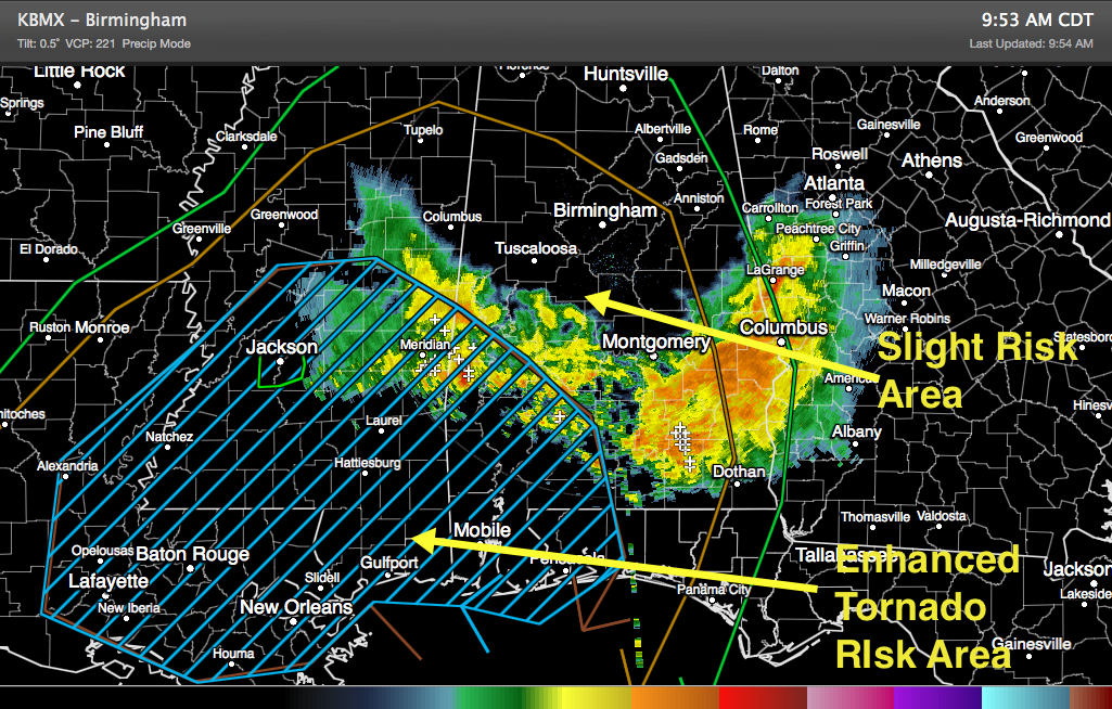
While we can’t rule out a tornado anywhere across Central Alabama overnight and early Monday morning, the best chance will be south and west of a line from Haleyville to Springville/Pell City on to Tuskegee, Ozark and Seaside. This area, which is also the slight risk area for the day, was expanded slightly on the 8:00 a.m. update from the SPC. There is an enhanced area of slightly higher tornado probabilities (10% chance with in 25 miles) over southwestern parts of Alabama, south and west of a line from Livingston to Camden, Pine Apple and then east of Evergreen. It does NOW include coastal Mobile and Baldwin Counties.
HOW THE SYSTEM WILL UNFOLD: Moderate to heavy rain with embedded thunderstorms moved over South and South Central Alabama this morning. More light to moderate rain was moving northeast by mid-morning and will affect the rest of Central Alabama into the afternoon, increasing with time. Most of the thunder should be limited to South Alabama, although some lightning was showing up southwest of Demopolis at 9:30 a.m. There will be some more thunder through the afternoon.
As the surface low moves into Central Mississippi this evening, a warm front will be pushed north over Central Alabama. This will be accompanied by increasing rain and storms. While those shouldn’t be severe, they will be loud. Locations south of the front will be in the warm sector with rising temperatures and dewpoints and increasing instability leading to strong to severe thunderstorms. Discrete storms ahead of the front will be especially troublesome given the magnitude of the wind shear. Rain and thunderstorms will continue for much of the night across much of the area. The main activity should push east of I-65 by lunchtime, continuing to affect East Central and Southeast Alabama with a severe weather threat. There will be some lingering showers into the afternoon over western sections into the afternoon and eastern sections into the evening.
FLASH FLOOD THREAT: A Flash Flood WAach went into effect at 10 a.m. CDT for all of Central Alabama. It will be in effect until Monday afternoon. Widespread 1 to 2 inch rainfall amounts with some locally higher amounts between 3-4 inches could cause flooding.
TEMPERATURES: Readings have been slow to climb over Central sections due to the clouds and increasing showers. Areas that get rain earlier may hae their highs limited to the upper 50s today, while you will find 60s the further north you go. Lows tonight will actually come early in the evening in many spots as the warmer air moves in. Official lows will probably be in the upper 50s, but by morning, readings will be in the middle 60s. Highs tomorrow will likely rise to near 70F, before tumbling back into the lower and middle 40s Monday night.
Category: Alabama's Weather, Severe Weather
About the Author (Author Profile)
Bill Murray is the President of The Weather Factory. He is the site's official weather historian and a weekend forecaster. He also anchors the site's severe weather coverage. Bill Murray is the proud holder of National Weather Association Digital Seal #0001 @wxhistorianSubscribe
If you enjoyed this article, subscribe to receive more just like it.


