

A Late night Look at the Alabama Weather Situation
There still is a significant threat of severe weather overnight across Central Alabama.

An impressive 850 millibar jet is acting like a firehose tonight, pouring warm, moist air into West Central Alabama from Mississippi.
This area of inbound warmth and moisture is resulting in widespread heavy rain and thunderstorms over West Central Alabama. The storms have produced some wind damage in places like Pickens and western Tuscaloosa Counties, as well as Marengo County. Numerous trees were reported down along US-82 near Buhl.
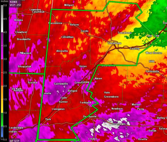
They have also triggered a flash flood warning for four counties in West Central Alabama including Greene, Pickens, Sumter and Tuscaloosa Counties where radar estimates show 2-3 inches of rain had probably fallen. A flash flood warning was just issued for Fayette, Jefferson, Lamar and Walker Counties until 5:30 AM CDT.
The flash flood watch continues for Autauga, Barbour, Bibb, Blount, Bullock, Calhoun, Chambers, Cherokee, Chilton, Clay, Cleburne, Coosa, Dallas, Elmore, Etowah, Fayette, Greene, Hale, Jefferson, Lamar, Lee, Lowndes, Macon, Marengo, Marion, Montgomery, Perry, Pickens, Pike, Randolph, Russell, Shelby, St. Clair, Sumter, Talladega, Tallapoosa, Tuscaloosa, Walker and Winston Counties until 1:00 PM CDT Monday.
As of 11:50 p.m. tonight, there were no severe thunderstorm warnings nationally, but that will change.
The warm, moist airmass the jet is bringing north will eventually lead to significant instability, especially over southwestern and North Central Alabama. Right now, all of the surface based CAPE is limited to counties near the coast.
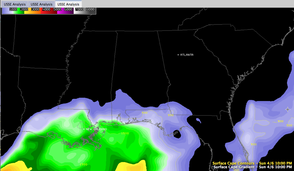
This will change rapidly over the next few hours as the jet continues to pump in the warm, moist air.
The upper level trough is becoming more negative in its orientation. The negative orientation increases the severe weather threat as colder air aloft is able to destabilize the atmosphere. It also increases the amount of wind shear present as well.
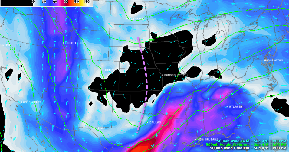
Finally, the wind shear over Alabama is significant.
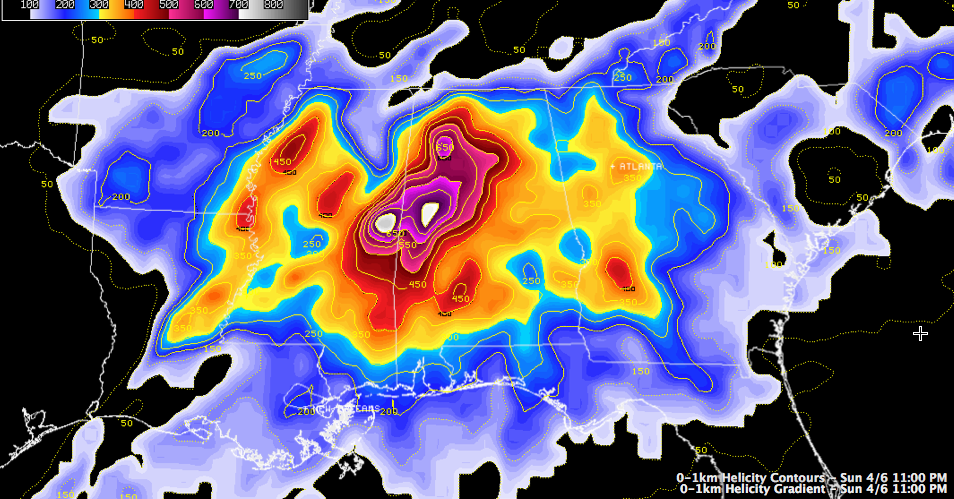
0-1km helicity is very high over western sections of Alabama. If that hangs in there until the instability arrives, it will enhance the threat of severe weather. Bulk shear numbers are high as well, meaning storms will have no trouble getting and staying organized.
WATCHING RADAR
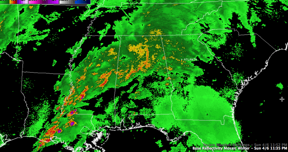
Supercell storms over Louisiana and Mississippi are triggering severe thunderstorm and tornado warnings. The storms will push northeast into Central Alabama later tonight. If they encounter an airmass with a moderate amount of instability and the current high shear, there will be problems.
IN SUMMARY
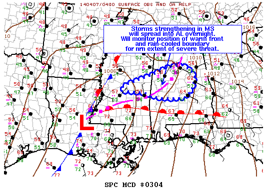
Where the instability values can reach 750 j/kg or more overnight, there will be a significantly enhanced threat of severe weather because of the shear. The SPC just noted that there is a 60% chance they will issue a watch for Central Alabama soon. Here is the MCD Graphic:
Category: Alabama's Weather, Severe Weather
About the Author (Author Profile)
Bill Murray is the President of The Weather Factory. He is the site's official weather historian and a weekend forecaster. He also anchors the site's severe weather coverage. Bill Murray is the proud holder of National Weather Association Digital Seal #0001 @wxhistorianSubscribe
If you enjoyed this article, subscribe to receive more just like it.


