

An Evening Update
It has been a rainy, cloudy and cool day across Central Alabama, with a chilly easterly breeze thrown in for good measure. Highs in the I-20 corridor were generally in the upper 50s. The high in Tuscaloosa was 60F. When it was raining, it was even cooler, with the mercury falling back into the lower 50s. It never got out of the 40s on Mount Cheaha, Alabama’s highest point.
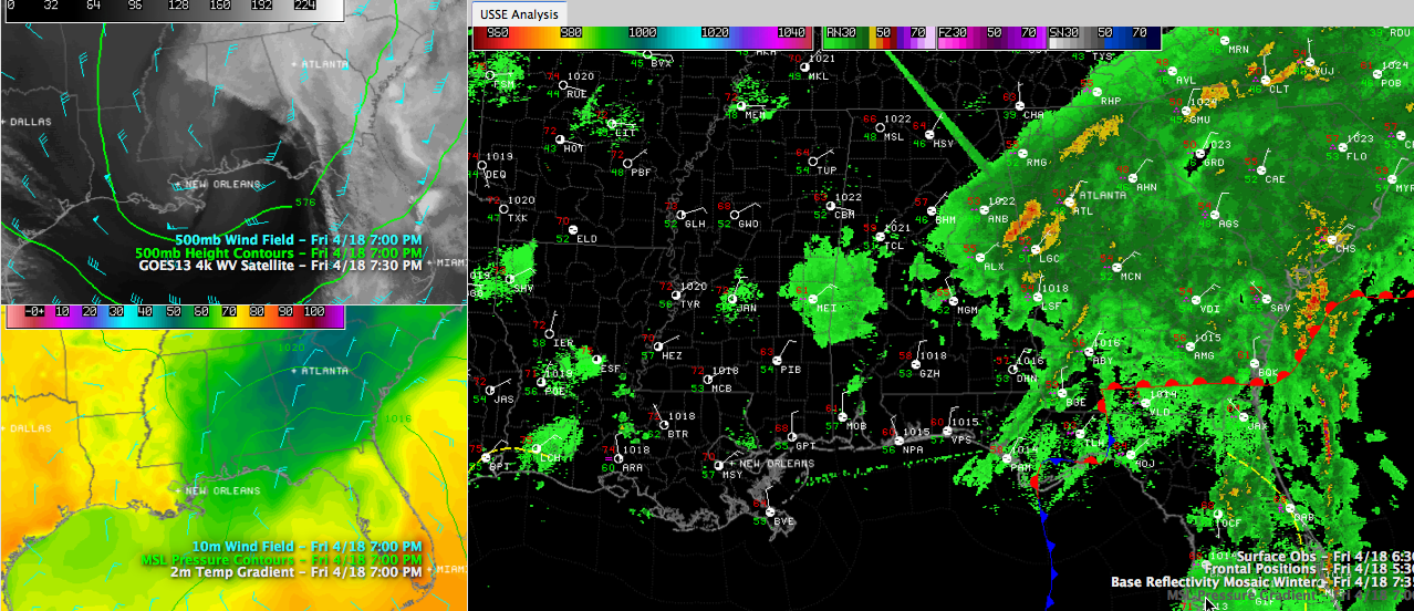
Rainfall amounts were generally light across our part of the state, including .20″ at Tuscaloosa and 0.19″ at Birmingham. 0.52″ has fallen at Anniston through 7 p.m., and it was still raining.
Click to enlarge.
While rainfall amounts over North Central Alabama were light today, it was a different story to the south, as moisture from the Gulf rode up an over a dome of high pressure extending down from New England and the Mid-Atlantic. Montgomery got over an inch and a half (1.62″), but nearer the coast, amounts were dramatically higher. Pensacola picked up nearly four inches of rain and Destin over inches. Florala, on the Alabama/Florida border picked up over five inches! Flooding was reported in numerous spots across Walton County, Florida, just over the border between Florala and DeFuniak Springs. All in all, it was not a good day to be driving to Destin on US-331. Beachgoers will encounter improving conditions today and fine weather Sunday and Monday.
At 7:45 p.m., light to moderate rain continues over the eastern part of Alabama, with the heaviest precipitation over Randolph, Chambers and eastern Lee Counties. It was raining moderately in Tennant and Roanoke.
We will be tracking a developing upper level low along the Louisiana/Mississippi border as it moves east tonight. It could increase rainfall again over Central Alabama during the overnight hours, but there is a lot of uncertainty in that between the short term models. Lows will be near 50F.
Eastern Alabama will have clouds tomorrow and a chance of a few showers because of the effect of that upper low. Western areas (places like Tuscaloosa, Hamilton and Jasper will experience a good supply of sunshine. I-65 communities from Cullman to Birmingham to Clanton will be in the transition zone. Areas west of I-65 will warm well into the 70s Saturday afternoon, eastern areas will be in the 60s.
Saturday night lows will be near 50F, so sunrise services will be mostly clear with a little fog, but dry and cool with readings in the upper 40s to near 50F. Afternoon readings Sunday will be in the middle 70s across the area.
Category: Alabama's Weather
About the Author (Author Profile)
Bill Murray is the President of The Weather Factory. He is the site's official weather historian and a weekend forecaster. He also anchors the site's severe weather coverage. Bill Murray is the proud holder of National Weather Association Digital Seal #0001 @wxhistorianSubscribe
If you enjoyed this article, subscribe to receive more just like it.


