

Early Afternoon Update
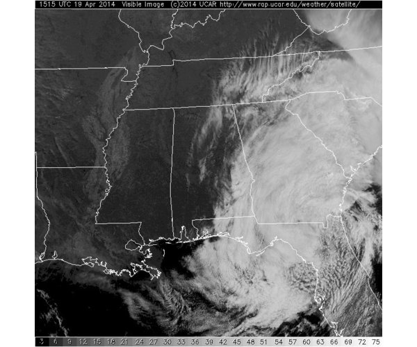
Another fascinating look at the storm system to our southeast today. The surface low and upper-level low are both located on the Georgia/Florida line this afternoon. Clouds and rain continue to fall in many areas to our east with this system. The last few satellite images it appears to look like the clouds are bubbling up over southeastern Georgia. These are actually thunderstorms that have developed in the area and the strong updrafts in the storms are allowing the cloud tops to make it higher than the lower cumulus and stratus clouds affecting most areas.
For us in Alabama, if you are west of Interstate 65, there is hardly a cloud in the sky as beautiful blues skies are allowing an abundance of sunshine through. East of Interstate 65, there is a mix of sun and clouds, which becomes more overcast the farther east you go. There are still a few very light showers showing up on radar this afternoon east of I-65 and south of I-20.
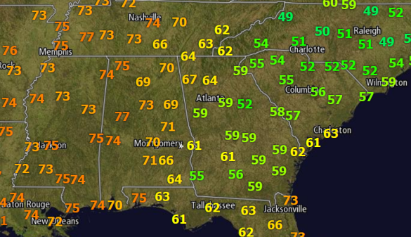
Where the clouds and rain are, it is quite a cool and raw day. Temps are staying in the 50s across much of Georgia and the Carolinas, with even some 40s in North Carolina. Where the sun is out over most of Alabama, temps are well into the 70s and it has turned out to be a beautiful spring Saturday. At last check I noticed the temperature at Auburn was 59 degrees verses the 77 in Tuscaloosa.
For the rest of today, these lows will continue to slowly shift off to the east and will gradually allow skies to clear over eastern portions of the state later this evening.
Category: Alabama's Weather
About the Author (Author Profile)
Macon, Georgia Television Chief Meteorologist, Birmingham native, and long time Contributor on AlabamaWX. Stormchaser. I did not choose Weather, it chose Me. College Football Fanatic. @Ryan_StinnetSubscribe
If you enjoyed this article, subscribe to receive more just like it.


