

Dry Air Returns Tonight
An all new edition of the ABC 33/40 Weather Xtreme video is available in the player on the right sidebar of the blog. You can subscribe to the Weather Xtreme video on iTunes by clicking here.
RADAR CHECK: We have a few heavy showers on radar at mid-afternoon near the I-20 corridor (Tuscaloosa to Birmingham to Anniston), but I haven’t seen any lightning strikes showing up, and it looks like thunder will be unlikely for our state this evening. Temperatures are mostly in the 68-73 degree range, and the sky is mostly cloudy.
The rain will end later this evening, and we expect a clearing sky tonight as drier air works down into the state.
TOMORROW/THURSDAY: These days look mostly sunny; we reach the mid to upper 70s tomorrow, followed by low to mid 80s Thursday. In fact, Thursday could be the warmest day so far this year for many Alabama communities.
A surface front could bring a few showers into the state Thursday night, however.
FRIDAY AND THE WEEKEND: That front will move into Central Alabama, stall, and dissipate over these three days. Bottom line is that we will continue to mention a chance of widely scattered showers Friday, Saturday, and Sunday, but the rain will be light and spotty, and the sun should be out at times. And, the weather stays warm with highs up in the low to mid 80s. A nice summer preview.
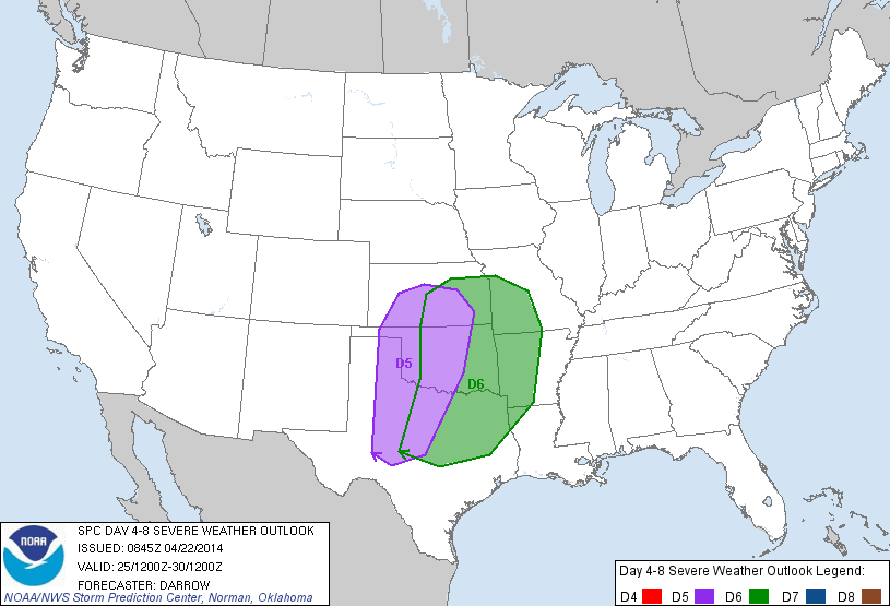
TO THE WEST: A significant severe weather event is possible this weekend over North Texas and parts of the Southern Plains… (D5 is Saturday; D6 is Sunday)…
EARLY NEXT WEEK IN ALABAMA: Still too early to really determine the threat of severe weather in our state early next week. The 12Z GFS hints the main window for thunderstorms will come from about 6:00 p.m. Monday through 6:00 a.m. Tuesday, and severe weather parameters, while not overwhelmingly strong, do suggest some risk of thunderstorms with hail and strong winds. Just too early to determine if there will be a tornado threat. See the Weather Xtreme video for the maps, graphics, and details.
LATE NEXT WEEK: Global models develop a long wave upper trough over the eastern U.S. in the April 30-May 2 time frame, which would imply temperatures well below average here in Alabama and across the Deep South. I don’t think we will have to worry about a freeze threat, but on one morning late next week there could be a touch of frost across the colder valleys and protected areas of Northeast Alabama. Again, see the video for more details.
AT THE BEACH: A few scattered showers tonight from Panama City over to Gulf Shores, but nothing too heavy or widespread. Then, mostly sunny days and fair nights tomorrow through the weekend. A few isolated showers could show up Friday and Saturday, but the chance of any one spot seeing rain is small. Highs along the immediate coast will be in the 68-72 degree range because of the cooler ocean water; but just a few miles inland highs will rise into the low to mid 80s. Sea water temperatures remain in the mid 60s.
WEATHER RADIO TOUR: We will be at the Publix in the McCalla/Bessemer area (just off I-459 exit one) tomorrow from 3:30 until 6:30 p.m. If you need your weather radio programmed, or have questions, or need to buy one, come see us.
WEATHER BRAINS: Don’t forget you can listen to our weekly 90 minute netcast anytime on the web, or on iTunes. This is the show all about weather featuring many familiar voices, including our meteorologists here at ABC 33/40. Scroll down for the show notes on the new episode we recorded last night.
CONNECT: You can find me on all of the major social networks…
Facebook
Twitter
Google Plus
Instagram
I enjoyed seeing the pre-schoolers today at Holy Spirit Catholic School in Tuscaloosa, and the second graders at Deer Valley Elementary in Hoover. Be looking for them on the Pepsi KIDCAM today at 5:00 and 6:00 on ABC 33/40 News! The next Weather Xtreme video will be posted here by 7:00 a.m. tomorrow….
Category: Alabama's Weather
About the Author (Author Profile)
James Spann is one of the most recognized and trusted television meteorologists in the industry. He holds the AMS CCM designation and television seals from the AMS and NWA. He is a past winner of the Broadcast Meteorologist of the Year from both professional organizations.Subscribe
If you enjoyed this article, subscribe to receive more just like it.


