

Warm Days Ahead
An all new edition of the ABC 33/40 Weather Xtreme video is available in the player on the right sidebar of the blog. You can subscribe to the Weather Xtreme video on iTunes by clicking here.
SEVERE CLEAR: Hard to find a decent cloud in the Alabama sky this afternoon; temperatures are generally in the mid to upper 70s, the humidity is low, and the visibility is excellent. Tonight will be clear and cool… we drop into the upper 40s by daybreak.
WARMER TOMORROW: Tomorrow will be another dry day; the sky partly to mostly sunny with a high up in the low 80s, making it one of the warmest days so far in 2014. To the west, SPC has the standard “slight risk” of severe weather up from roughly Memphis down to Shreveport, but those storms will fizzle fast as they near Alabama late tomorrow night.
FRIDAY: A band of showers and storms will enter the northwest corner of Alabama around midnight tomorrow night, but they will weaken quickly as the upper air support lifts out… by the time they reach Birmingham, Tuscaloosa, Anniston, and Gadsden during the pre-dawn hours (2:00 to 6:00 a.m.) there won’t be much left, and rain amounts will be light and spotty.
The day Friday looks nice with a partly sunny sky and a high around 80 degrees. I don’t expect any rain in the state after the early morning showers end.
THE ALABAMA WEEKEND: No doubt it will be the warmest weekend so far this year, with mid 80s Saturday and Sunday. The sky will be partly sunny both days, and the chance of rain looks very small. Not zero, but the chance of any one spot seeing an afternoon shower is only about one in ten, and barely worth mentioning in the forecast.
TO THE WEST: A very significant severe weather threat is shaping up for parts of the southern U.S. over the weekend…
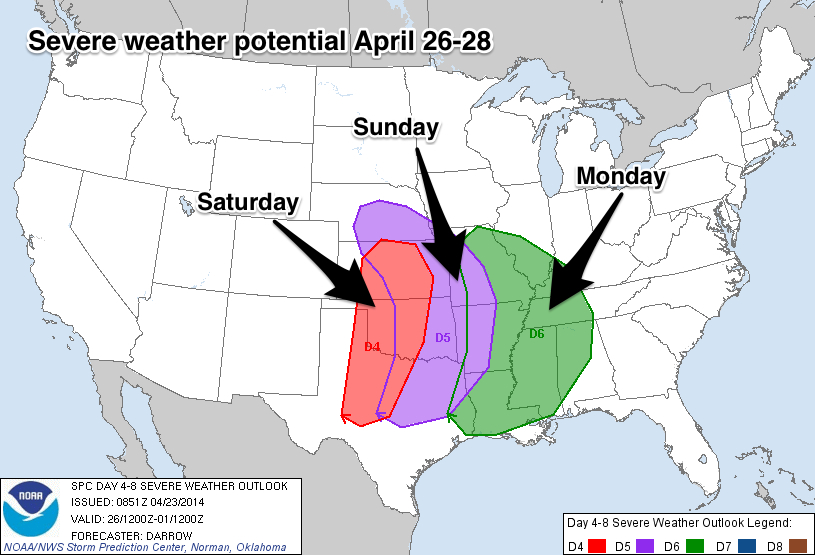
ALABAMA’S SEVERE WEATHER THREAT: Again I stress there is no way of knowing the small scale features now that will really determine the magnitude and scope of the severe weather risk in Alabama early next week, but parameters certainly look favorable for the dual risk of severe thunderstorms and heavy rain.
The 12Z GFS is a little faster, suggesting the main risk of strong to severe storms will come from about 3:00 p.m. Monday through 6:00 a.m. Tuesday. This could change again, however. But, if the storms do arrive Monday afternoon or Monday evening, the instability values would be higher, and the risk more substantial.
The forecast combination of instability, shear, wind fields, and lapse rates could suggest all modes of severe weather will be possible, including large hail, damaging winds, and a few tornadoes.
BIRMINGHAM WEATHER RADIO OUTAGE: It is important to note the Birmingham NOAA Weather Radio transmitter is down, and could be down until late next week. Received this note from John DeBlock at the NWS earlier today…
“The current NOAA Weather Radio All Hazards (NWR) transmitter outage in Birmingham, AL highlights the need to have a layered approach in receiving weather notifications. The National Weather Service (NWS) recommends that no one relies on a single technology or method to receive weather warnings, and we encourage everyone to plan ahead – now – for potential severe weather in the coming days and weeks.
A good layered approach will include as many of the following options as you can employ: NOAA Weather Radio All Hazards receiver, television and/or radio broadcasts, social media, cell phone apps, and text or e-mail notification services. We are blessed with excellent broadcast and media partners across Central Alabama that work with us and local emergency management agencies to help prepare and inform the public for severe weather. Similarly, there are any number of apps and notification services available for most smartphones and devices. The NWS doesn’t endorse any particular app or service, other than the one that YOU will use to keep you and your family safe! There is a free app which was made available to all Alabamians after the April 27th outbreak, which can be found at AlabamaSafTNet.com, and many of our local broadcast and media partners offer similar free services as well. Otherwise, a partial list of available E-mail and SMS Weather Alert Services can be found at https://www.weather.gov/subscribe.”
We recommend the MyWarn and iMap WeatherRadio smart phone apps with ABC 33/40 as your chosen partner so you can watch our streaming coverage.
COLD SNAP NEXT WEEK: After the rain and storms, the weather turns much colder here Wednesday. Looks like we won’t get out of the 50s thanks to a cold core upper trough over the eastern third of the nation, and some of the colder pockets around here could visit the upper 30s by daybreak Thursday or Friday morning.
Take a few minutes to watch the Weather Xtreme video for the maps, graphics, and more details on this active weather pattern.
WEATHER BRAINS: Don’t forget you can listen to our weekly 90 minute netcast anytime on the web, or on iTunes. This is the show all about weather featuring many familiar voices, including our meteorologists here at ABC 33/40.
CONNECT: You can find me on all of the major social networks…
Facebook
Twitter
Google Plus
Instagram
I enjoyed seeing the students this morning at Hokes Bluff Middle School… they will be on the Pepsi KIDCAM tomorrow evening at 5:00 on ABC 33/40 News. The next Weather Xtreme video will be posted here by 7:00 a.m. tomorrow….
Category: Alabama's Weather
About the Author (Author Profile)
James Spann is one of the most recognized and trusted television meteorologists in the industry. He holds the AMS CCM designation and television seals from the AMS and NWA. He is a past winner of the Broadcast Meteorologist of the Year from both professional organizations.Subscribe
If you enjoyed this article, subscribe to receive more just like it.


