

Showers Late Tonight/Early Tomorrow
An all new edition of the ABC 33/40 Weather Xtreme video is available in the player on the right sidebar of the blog. You can subscribe to the Weather Xtreme video on iTunes by clicking here.
BIG WARM-UP: We are starting off this day with some upper 30s over Northeast Alabama… Fort Payne reports 37, Black Creek is at 38 just before daybreak. But, despite the morning chill, we warm quickly today, and most communities will see a high in the low 80s this afternoon. The GFS is printing a high of 84 for Birmingham, and if we see that today will be the warmest day so far in 2014. The sky will be partly to mostly sunny.
TO THE WEST: SPC has the standard “slight risk” of severe weather up later today and tonight for areas northwest of Alabama, and that risk clips the northwest corner of our state.
A band of showers and thunderstorms will enter Northwest Alabama between 10:00 p.m. and midnight tonight, and initially the storms could be strong up around Muscle Shoals, Florence, Russellville, and Hamilton. Gusty winds and some small hail are possible, but the storms will weaken very quickly as they move deeper into Alabama, and by the time it reaches Birmingham, Tuscaloosa, Anniston, and Gadsden, we expect nothing more than scattered, light rain showers between 3:00 and 6:00 a.m.
TOMORROW: After those pre-dawn showers end, the day tomorrow looks very nice with ample sunshine and a high in the mid to upper 70s.
THE ALABAMA WEEKEND: It will be the warmest weekend so far this year with highs up in the mid 80s Saturday and Sunday. We expect a good supply of sunshine both days, and the chance of a shower is so small that we won’t mention it.
EYES TO THE WEST: While we enjoy a warm, calm weekend, a significant severe weather outbreak will unfold over the Southern Plains Saturday and Sunday as a vigorous, negative tilt upper trough moves out of the Rockies, encountering very unstable air. Severe thunderstorms with large hail, damaging wind, and a few tornadoes are possible Sunday west of our state.
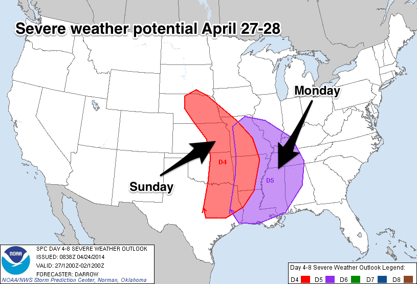
SPC continues a risk of severe weather over a good part of Alabama Monday.
THE ALABAMA SEVERE WEATHER THREAT: No doubt we will have the dual threat of heavy rain/flooding, and severe thunderstorms Monday, Monday night, and into Tuesday morning, but the exact details of how it all unfolds are still not clear at this early stage of the game.
The GFS hints some type of MCS (mesoscale convective system) could move into Alabama Monday morning with potential for heavy rain, but the core threat for severe weather still seems to be Monday afternoon and Monday night.
It remains to be seen how morning storms might impact the Monday evening threat, but the GFS shows a good bit of surface based instability Monday evening (CAPE values over 2,000 j/kg over West Alabama). Thankfully the low level bulk shear values have come down, but there is still sufficient shear for some tornado threat. The low level jet is in the 40-45 knot range, not overwhelming, but enough for strong to severe storms.
FLOODING THREAT: Rain amounts of over 3 inches are possible over North Alabama (generally along and north of I-20) Monday through Tuesday, and that could be enough for some flooding issues. If you live in a flood prone area, be aware of the possibility. This could actually turn out to be the biggest threat of the event.
IMPORTANT NOTE: You will probably hear all kind of hyperbole on the Internet and across social media about the event early next week. Nobody at this point really knows how the mesoscale features will play out that determine the true magnitude and scope of the threat. And, there is no need for comparisons to April 27, 2011. That was a generational event, and you probably won’t see another one like that for many, many years. But, remember, if there is only one tornado in the entire state, and if it happens to come through your neighborhood, then that becomes YOUR April 27. When people ask me “will this be like April 27?”… I don’t answer because of that.
COLDER AIR: After the rain and storms, the weather will turn colder by Wednesday and Thursday. The 00Z GFS has backed off on the strength of the upper trough over the eastern half of the U.S., but one way or another temperatures will be below average over the latter half of the week. I fully expect some of the colder North Alabama valleys and protected areas to reach the upper 30s by Thursday or Friday morning.
Take some time to watch the Weather Xtreme video for the maps, graphics, and details.
BIRMINGHAM WEATHER RADIO OUTAGE: It is important to note the Birmingham NOAA Weather Radio transmitter is down. Received this note from John DeBlock at the NWS last night…
“Based on some late afternoon updates, we are now hopeful that the Birmingham transmitter may be back on the air before the threat of severe weather next week.
As you can imagine, pulling together any sort of repair on short notice is challenging in the best of circumstances. We are working closely with technicians and our regional and national management teams to do everything we can to return the transmitter to operations as soon as possible.”
We recommend the MyWarn and iMap WeatherRadio smart phone apps with ABC 33/40 as your chosen partner so you can watch our streaming coverage.
AT THE BEACH: Mostly sunny days and fair nights on the coast through the weekend (from Panama City to Gulf Shores). Highs in the low 70s on the immediate coast, with mid 80s just a few miles inland. Showers and storms return to the Gulf Coast Monday and Tuesday of next week.
WEATHER BRAINS: Don’t forget you can listen to our weekly 90 minute netcast anytime on the web, or on iTunes. This is the show all about weather featuring many familiar voices, including our meteorologists here at ABC 33/40.
CONNECT: You can find me on all of the major social networks…
Facebook
Twitter
Google Plus
Instagram
I have a weather program this morning at Faucett-Vestavia Elementary in Northport… be looking for the next Weather Xtreme video here by 4:00 this afternoon. Enjoy the day!
Category: Alabama's Weather
About the Author (Author Profile)
James Spann is one of the most recognized and trusted television meteorologists in the industry. He holds the AMS CCM designation and television seals from the AMS and NWA. He is a past winner of the Broadcast Meteorologist of the Year from both professional organizations.Subscribe
If you enjoyed this article, subscribe to receive more just like it.


