

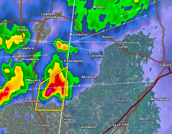
Strong Storm for Pickens County
Showers and storms are now moving into the state. Even though this cell has been severe, it continues to weaken as it moves east. The NWS in Birmingham has decided not to issue a warning for this storm at this time.
It will be producing gusty winds and some hail, and these should stay below severe criteria, but expect very heavy rainfall and frequent lightning. This storm will be affecting locations across southern Pickens County affecting Pickensville and Aliceville.
…SIGNIFICANT WEATHER ADVISORY FOR SOUTHERN PICKENS COUNTY UNTIL
1115 PM CDT…
AT 1023 PM CDT…THE NATIONAL WEATHER SERVICE WAS TRACKING A STRONG
THUNDERSTORM 12 MILES NORTHWEST OF PANOLA…OR 14 MILES SOUTHWEST OF
PICKENSVILLE…MOVING EAST AT 40 MPH.
HAIL UP TO THE SIZE OF NICKELS IS EXPECTED WITH THIS STORM…ALONG
WITH HEAVY RAIN AND FREQUENT DANGEROUS LIGHTNING.
LOCATIONS IN OR NEAR THE PATH OF THIS STORM INCLUDE…
ALICEVILLE…
GARDEN…
MCMULLEN…
BENEVOLA…
MEMPHIS…
TORRENTIAL RAIN…WHICH MAY FLOOD LOW LYING AREAS SUCH AS DITCHES AND
UNDERPASSES…IS ALSO LIKELY. DO NOT DRIVE YOUR VEHICLE ON A FLOODED
ROADWAY.
Category: Alabama's Weather
About the Author (Author Profile)
Macon, Georgia Television Chief Meteorologist, Birmingham native, and long time Contributor on AlabamaWX. Stormchaser. I did not choose Weather, it chose Me. College Football Fanatic. @Ryan_StinnetSubscribe
If you enjoyed this article, subscribe to receive more just like it.


