

Dangerous Storm East of Kansas City
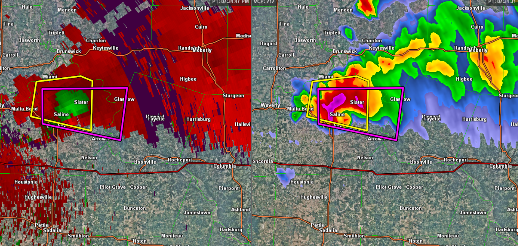
A tornadic supercell with a history of producing a tornado is moving across Central Missouri this evening. The storm is well east of Kansas City ans well west of St. Louis. It is just to the north of Interstate 70 and is moving east-southeast at 30 mph. The storm has terrific structure to it and an impressive couplet.
The storm is near Saline, MO and on it current track could affect the the city of Columbia, Missouri later this evening.
Click image to enlarge.
* TORNADO WARNING FOR…
EXTREME SOUTH CENTRAL CHARITON COUNTY IN NORTH CENTRAL MISSOURI…
WEST CENTRAL HOWARD COUNTY IN CENTRAL MISSOURI…
CENTRAL SALINE COUNTY IN CENTRAL MISSOURI…
* UNTIL 800 PM CDT
* AT 725 PM CDT…A SEVERE THUNDERSTORM CAPABLE OF PRODUCING A
TORNADO WAS LOCATED NEAR MARSHALL…AND MOVING EAST AT 30 MPH.
HAZARD…TORNADO AND PING PONG BALL SIZE HAIL.
SOURCE…RADAR INDICATED ROTATION.
IMPACT…FLYING DEBRIS WILL BE DANGEROUS TO THOSE CAUGHT WITHOUT
SHELTER. MOBILE HOMES WILL BE DAMAGED OR DESTROYED. DAMAGE
TO ROOFS…WINDOWS AND VEHICLES WILL OCCUR. TREE DAMAGE IS
LIKELY.
* LOCATIONS IMPACTED INCLUDE…
SLATER…GLASGOW AND GILLIAM.
PRECAUTIONARY/PREPAREDNESS ACTIONS…
TAKE COVER NOW. MOVE TO AN INTERIOR ROOM ON THE LOWEST FLOOR OF A
STURDY BUILDING. AVOID WINDOWS. IF IN A MOBILE HOME…A VEHICLE OR
OUTDOORS…MOVE TO THE CLOSEST SUBSTANTIAL SHELTER AND PROTECT
YOURSELF FROM FLYING DEBRIS.
Category: Headlines, Severe Weather
About the Author (Author Profile)
Macon, Georgia Television Chief Meteorologist, Birmingham native, and long time Contributor on AlabamaWX. Stormchaser. I did not choose Weather, it chose Me. College Football Fanatic. @Ryan_StinnetSubscribe
If you enjoyed this article, subscribe to receive more just like it.


