Showers/Storms Increase By Wednesday
An all new edition of the ABC 33/40 Weather Xtreme video is available in the player on the right sidebar of the blog. You can subscribe to the Weather Xtreme video on iTunes by clicking here.
RADAR CHECK: As expected, we have a handful of widely scattered showers and storms across the great state of Alabama this afternoon. Most of them are west and south of Birmingham, and they will fade away after the sun goes down later this evening. It is a very warm, muggy afternoon with temperatures in the 80s and dewpoints in the 60s.
TOMORROW: Not much change; warm and humid weather continues with a high between 87 and 90, and a few spots could see a brief afternoon shower or storm in widely scattered places. The high resolution NAM model hints some thunderstorms could move into Alabama late tomorrow night ahead of a large upper trough, now over the western half of the nation.
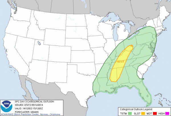
WEDNESDAY/THURSDAY: Showers and storms become likely statewide Wednesday. SPC has parts of North and West Alabama in the standard “slight risk” of severe weather for Wednesday and Wednesday night…
Looks like a summer setup with high CAPE values (the new model runs show surface based CAPE values exceeding 2,000 j/kg Wednesday afternoon), but with little shear and relatively weak wind fields (low level jet under 30 knots). So, strong storms are certainly possible Wednesday, but if they become severe it looks like hail and gusty winds will be the primary threat. Rain amounts of 1/2 to one inch are likely.
Thursday will be much cooler with rain ending from west to east during the morning. The latest model data hints clouds could hang around all day with temperatures not getting out of the 60s.
FRIDAY AND THE WEEKEND: These three days look generally dry and very pleasant for mid-May, with below average temperatures and low humidity levels. A large upper trough will cover the eastern third of the nation; with short waves rotating though the bottom of the trough, we can’t rule out a shower, or a little light rain somewhere over North Alabama Friday or Saturday, but with low dewpoints the chance of really significant rain for now looks small. Expect partly to mostly sunny days with highs in the 70s.
See the Weather Xtreme video for the maps, graphics, and details.
WEATHER BRAINS: Don’t forget you can listen to our weekly 90 minute netcast anytime on the web, or on iTunes. This is the show all about weather featuring many familiar voices, including our meteorologists here at ABC 33/40. We will produce this week’s show at 8:30 CT tonight… you can watch it on “James Spann” 24/7 on cable systems around the state, or on the web here.
CONNECT: You can find me on all of the major social networks…
Facebook
Twitter
Google Plus
Instagram
I enjoyed seeing the kids at Christ Harbor United Methodist Church in Northport today…. be looking for them on the Pepsi KIDCAM today at 5:00 on ABC 33/40 News! The next Weather Xtreme video will be posted here by 7:00 a.m. tomorrow….
Category: Alabama's Weather


