

Numerous Showers and Storms This Afternoon
Meteorological summer arrived on this June 1st across Central Alabama. While astronomical summer doesn’t start until June 21st, we Weather Humans, as J.B. says, could June 1st as the beginning of our summer. The months of June, July and August are the warmest months based on the temperature cycle, hence we call them meteorological summer. So, welcome to summer!
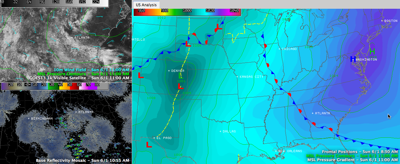
Weatherwise, we find a significant upper high building over eastern Kentucky on this first Sunday in June. This feature will increasingly play a role in Alabama’s weather over the coming days, leading to some warm conditions. There is a deepening upper level trough over the Rockies an a surface low near Denver.
That means severe weather ahead for the Plains and indeed, the SPC has the area from the Texas Panhandle northward through the Plains states all the way into southwestern Minnesota outlooked for severe weather today. There could be some more significant severe weather, especially Tuesday over the Central Plains.
Nothing like that here though. The deep trough we experienced has moved off the East, abandoning its upper level low we have ben tracking for well over a week. And we’re not going to be through with it anytime soon. It is actually having the last laugh, as it taps Gulf moisture and hurls it northward into the Deep South from its position near Houston.
Our moisture levels are pretty high, about 75% of theoretical capacity for this time of year, between one and two significant deviations above the mean, statistically. Moisture levels are forecast to rise through the afternoon thanks to the upper low. At the surface, strong high pressure is near Washington, D.C. and this high is wedging down into the Carolinas and Georgia. Its front man is a back door cold front that has run out of steam along the Alabama/Georgia border.
FOR YOUR SUNDAY: Moisture pooling ahead of the front, surface heating and the spark of the front itself will trigger fairly numerous showers and storms over the state this afternoon. Clouds have been pretty thick through the morning hours and this will hold temperatures back a bit. Highs this afternoon should generally be in the lower 80s. That will be sufficient to fire convection and rain chances will be in the 60-70% range this afternoon. Average rainfall amounts will be around a third of an inch, but of course, some places will get a lot more.
Last evening there was some impressive flooding near Oxford High School in Calhoun County. 1.5 to 2 inches of rain fell in a short time, while at the Anniston Airport nearby, only 0.34 inches of rain was measured.
RADAR CHECK: At 11:15, showers shower intensifying along the Alabama/Georgia border from southern Cleburne County into Randolph County, with others building near Columbus GA. These showers will grow and some of them will become storms as they move northwestward into the state of Alabama. They will be joined by others as well and showers and storms will be plentiful through the rest of the afternoon. They won’t be severe, but the heavier ones will potentially cause flooding in local spots and will also produce heavy rain.
Category: Alabama's Weather
About the Author (Author Profile)
Bill Murray is the President of The Weather Factory. He is the site's official weather historian and a weekend forecaster. He also anchors the site's severe weather coverage. Bill Murray is the proud holder of National Weather Association Digital Seal #0001 @wxhistorianSubscribe
If you enjoyed this article, subscribe to receive more just like it.


