

Strong/Severe Storms Again Today
An all new edition of the ABC 33/40 Weather Xtreme video is available in the player on the right sidebar of the blog. You can subscribe to the Weather Xtreme video on iTunes by clicking here.
AT DAYBREAK: We have a few showers and storms over the western half of the state early this morning, moving northeast in the moist environment over Alabama.
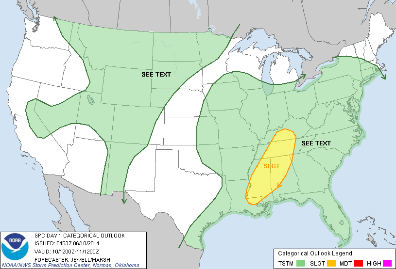
We expect more active weather today with the dual risk of severe thunderstorms and flash flooding. SPC has much of the state west of a line from Anniston to Clanton to Chatom under the standard “slight risk” of severe weather today…
In addition, a flash flood watch is in effect for much of North and West Alabama, generally along and north of I-59. Additional rain amounts of over two inches could produce some flooding problems through tomorrow.
THE SEVERE WEATHER THREAT: Like recent events, hail and strong straight line winds are the primary threats today, however with good upper support from a trough to the west providing a decent amount of shear, we can’t rule out an isolated tornado. Tornadoes are rare in Alabama in June, but they can happen, and the synoptic scale system impacting the state today looks more like something you would see in April or May.
The core severe risk will come from about 12:00 noon through 9:00 p.m. Be sure and pay attention to the various watches and warnings that will be needed today.
TOMORROW: Still looks wet with scattered to numerous showers and thunderstorms. The severe weather risk will be lower, but flash flooding remains possible.
THURSDAY/FRIDAY: Storms become a bit more scattered in nature, and mainly during the afternoon and evening hours; the high Thursday will be in the mid 80s, followed by upper 80s Friday. Both days will feature a mix of sun and clouds.
THE ALABAMA WEEKEND: Another upper trough west of the state will keep the weather somewhat unsettled. Scattered showers and storms are still possible Saturday and Sunday, perhaps numerous at times. The sun will be out occasionally, however, and highs will be in the upper 80s.
NEXT WEEK: The weather should be drier if the GFS verifies; it develops a 500 mb upper high over the Deep South early in the week. This would mean only widely scattered afternoon storms, and hotter afternoons with low 90s possible. See the Weather Xtreme video for the maps, graphics, and details.
AT THE BEACH: Just a few widely scattered showers and storms today from Panama City to Gulf Shores, but thunderstorms become more likely tomorrow. Later this week and over the weekend, about 5 to 7 hours of sunshine each day with a few scattered showers and storms around. Highs will remain in the 80s, and the sea water temperature is generally in the low 80s.
TROPICS: All is quiet across the Atlantic basin for now and tropical storm formation is not expected this week.
WEATHER BRAINS: Don’t forget you can listen to our weekly 90 minute netcast anytime on the web, or on iTunes. This is the show all about weather featuring many familiar voices, including our meteorologists here at ABC 33/40. Scroll down for the show notes on the new episode we recorded last night.
CONNECT: You can find me on all of the major social networks…
Facebook
Twitter
Google Plus
Instagram
Look for frequent updates on the Alabama weather situation through the day…
Category: Alabama's Weather
About the Author (Author Profile)
James Spann is one of the most recognized and trusted television meteorologists in the industry. He holds the AMS CCM designation and television seals from the AMS and NWA. He is a past winner of the Broadcast Meteorologist of the Year from both professional organizations.Subscribe
If you enjoyed this article, subscribe to receive more just like it.


