

Severe Thunderstorm Warning SE Cherokee County Til 1 p.m
LATE NOTE AT 12:38
The NWS has canceled the warning. The storm has weakened below severe limits, but is causing torrential rains, copious lightning and strong gusty winds now over southern Cherokee County, brushing across northeastern Calhoun County near Piedmont and about to move into northern Cleburne County. Stay alert for these hazards as this storm moves over your location.

Strong storms over Northeast Alabama have become strong this afternoon. One over southeastern Cherokee County is now potentially severe.
The storm approaching Pleasant Gap is capable of producing large hail to the size of quarters and perhaps larger. Winds could reach 60 mph which will produce damage.
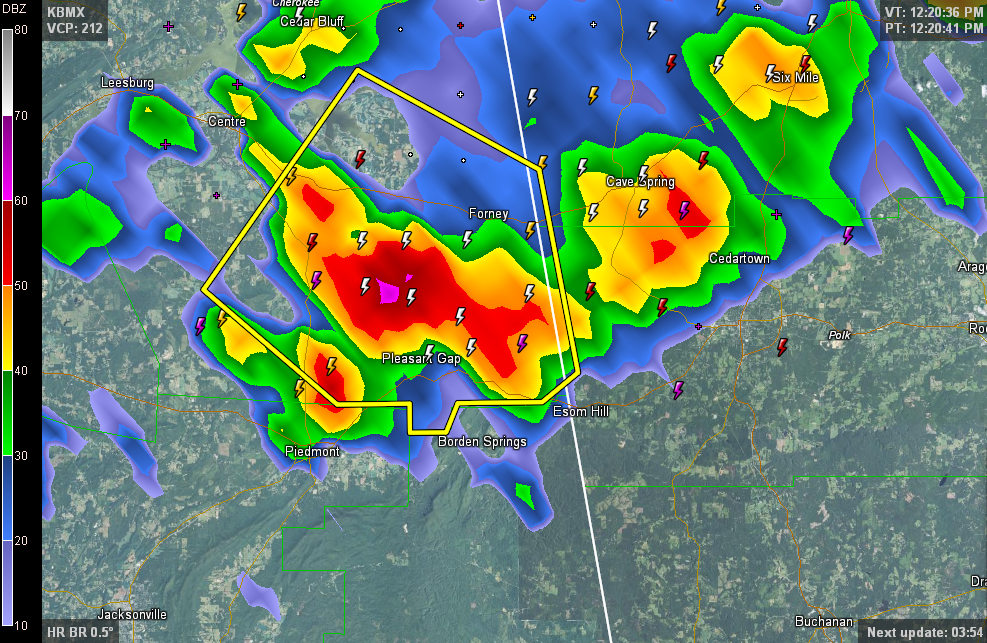
THE NATIONAL WEATHER SERVICE IN BIRMINGHAM HAS ISSUED A
* SEVERE THUNDERSTORM WARNING FOR…
SOUTHEASTERN CHEROKEE COUNTY IN NORTHEAST ALABAMA…
* UNTIL 100 PM CDT
* AT 1211 PM CDT…THE NATIONAL WEATHER SERVICE INDICATED A SEVERE
THUNDERSTORM CAPABLE OF PRODUCING QUARTER SIZE HAIL…AND DAMAGING
WINDS IN EXCESS OF 60 MPH. THIS STORM WAS LOCATED 5 MILES WEST OF
FORNEY. THIS STORM WAS NEARLY STATIONARY.
* LOCATIONS IMPACTED INCLUDE…
FORNEY…PLEASANT GAP AND SPRING GARDEN.
Category: Alabama's Weather, Severe Weather
About the Author (Author Profile)
Subscribe
If you enjoyed this article, subscribe to receive more just like it.


