

Watching Storms Tonight
Taking a Friday evening look at the Alabama Weather Situation.
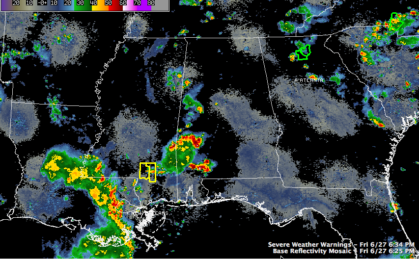
We are tracking a couple of systems on regional radars tonight that have impact and potential impact on the state overnight.
An upper level disturbance near Columbus MS has a pronounced spin on it, and it is triggering an area of showers and storms over eastern Mississippi into western Alabama. The activity extends down into southwestern Alabama and trails back into southeastern Mississippi, where the storms are intense. There is a severe thunderstorm warning for parts of a couple of counties in southern Mississippi.
This disturbance will continue moving northeast. It remains to be seen whether the storms will hold together or not. One of our mesoscale models moves them up into Central Alabama before weakening them around midnight. Another is picking up on the newer development and carrying showers and storms up into the Birmingham area just after midnight before having them dissipate over Northeast Alabama during the pre-dawn hours. Another model doesn’t have a good handle on the system at all.
Right now, the heaviest storms in West Central Alabama are over southern Lamar County near Vernon and over northern Hale County near Moundville. The Hale County storm will be approaching Brent in Bibb County before 7:30 and the Lamar County storm will make it to near Winfield by that same time as they move east northeast and northeast respectively.
Further south, strong storms over southern Marengo and Choctaw Counties are moving more northerly, toward Linden and Thomaston, but it will take them a couple of hours to get to Demopolis.
Further back to the southwest, another disturbance extends from Alexandria LA to Baton Rouge and New Orleans. This system should weaken as it moves into Mississippi overnight.
More showers and storms will likely develop tomorrow over Alabama with the trough remaining just to our west. This despite a ridge trying to build over the northern Gulf Coast into Alabama. The ridge will really start to win the battle by Sunday, leading to drier and hotter conditions.
Category: Alabama's Weather, Severe Weather
About the Author (Author Profile)
Bill Murray is the President of The Weather Factory. He is the site's official weather historian and a weekend forecaster. He also anchors the site's severe weather coverage. Bill Murray is the proud holder of National Weather Association Digital Seal #0001 @wxhistorianSubscribe
If you enjoyed this article, subscribe to receive more just like it.


