

Arthur He Does As He Pleases
The references to the Christopher Cross song from the movie Arthur are irresistible as we track our first tropical storm of the Atlantic season. Someone said today that it will only affect areas between the moon and New York City. Gotta love that one. My contribution is the title of this post.
First, let us reiterate that Arthur will have no direct impact on our weather in Alabama or the weather along the northern Gulf Coast. It will have a small, indirect hand in making the weather better through the Fourth of July weekend.
But, Arthur is a potential worst case scenario for forecasters and emergency managers. We have a relatively weak storm that has the potential to grow in to a significant hurricane pretty quickly while only a short distance from a coastline crowded with holiday vacationers.
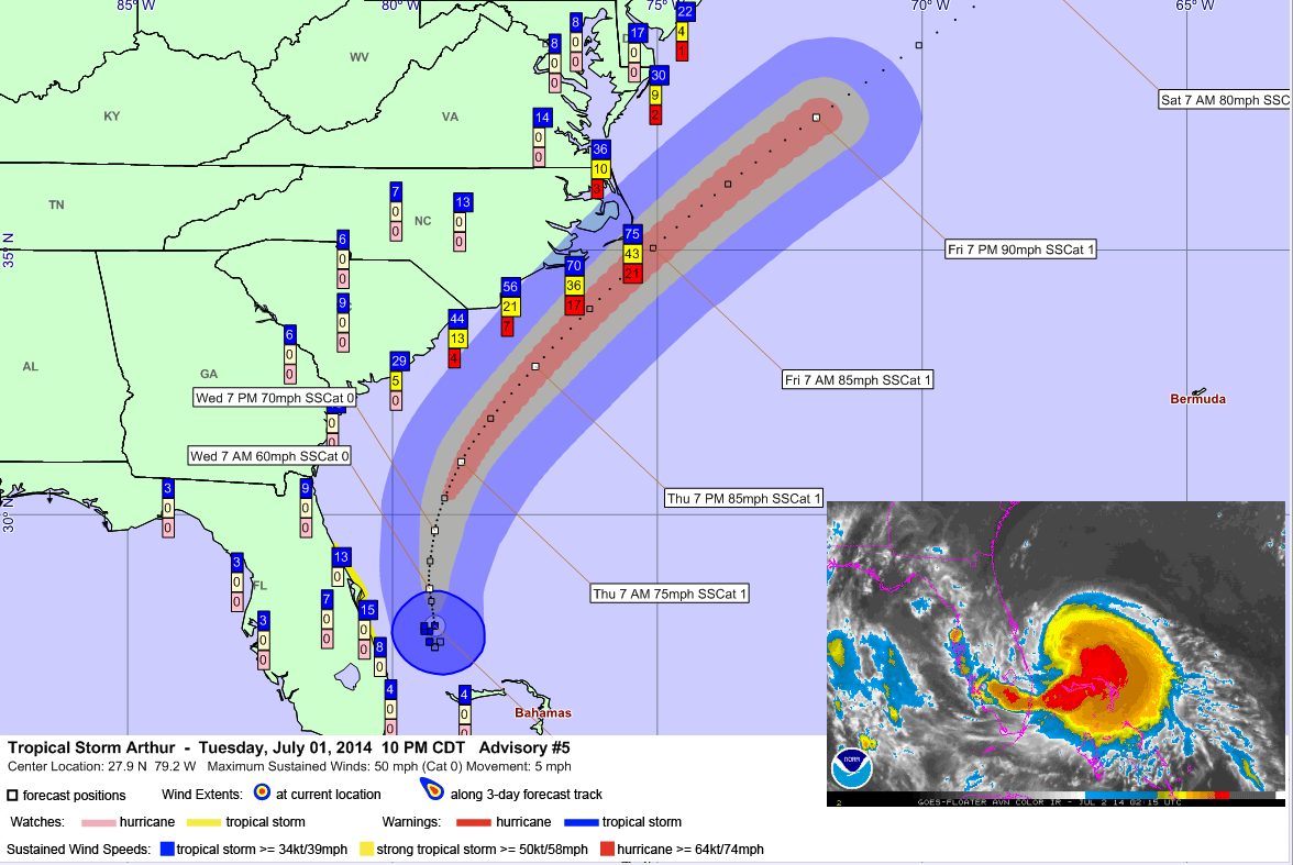
Arthur will be strengthening more tomorrow while tracking more northeastward about 100 miles off the coast of northeastern Florida. It should become a hurricane tomorrow or tomorrow night.
By Thursday morning, the center should be about 125 miles southeast of Charleston, South Carolina and by nightfall, it should be about 80 miles southeast of Myrtle Beach.
The center may pass right over the Outer Banks of North Carolina early Friday morning as a strong Cat 1 hurricane with top winds of 85 mph.
Here is the NWS National Digital Forecast Database representation of the storm at 1 a.m. Friday morning, depicted in the wind field.
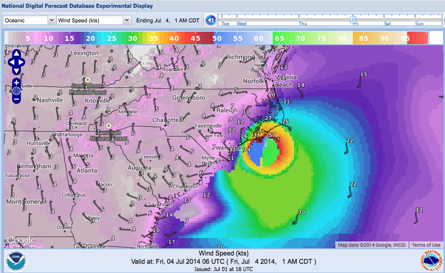
On the graphic, I have overlain the probabilities of tropical storm force winds (39 mph – blue), strong tropical storm force winds (58 mph – yellow) and hurricane force winds (74 mph – red) on the little colored number stacks. You can see about an even chance places like Charleston and Myrtle Beach will see tropical storm force winds and a better chance along the North Carolina coast.
Click image to enlarge
The best chance for hurricane force winds will be along the Outer Banks, but based on the official forecast, the probability for hurricane force winds there is still only about 20%. Hurricane force winds will be most likely along much of the Outer Banks early Friday morning, with improving conditions later in the day on the Fourth.
I have overlain the wind swatch along the official track as well, shown in blue, gray and red for TS, strong TS and hurricane force.
There is a tropical storm watch (shown in yellow) along the East Coast of Florida.
The impact to the South Carolina coast will not be tremendous, with a nearly even chance of tropical storm force winds. With the onshore flow ahead of the center, ides will be high, and there will almost certainly be flooding Charleston where it floods with any good inshore wind.
It is important to note that the forecast track can have errors. In fact, the “cone of uncertainty” from the NHC could carry the center as far west of Charleston SC or take it 150 miles east of Cape Hatteras. The good news is that the strongest wind field will be on the east, or oceanic, side of the storm.
The storm will quickly lose tropical characteristics as it races northeast, reaching Nova Scotia Saturday afternoon and Newfoundland Sunday evening.
If you are traveling to South Carolina or eastern North Carolina over the holiday weekend, check the latest forecasts and emergency information.
Category: Alabama's Weather, Tropical
About the Author (Author Profile)
Bill Murray is the President of The Weather Factory. He is the site's official weather historian and a weekend forecaster. He also anchors the site's severe weather coverage. Bill Murray is the proud holder of National Weather Association Digital Seal #0001 @wxhistorianSubscribe
If you enjoyed this article, subscribe to receive more just like it.


