An Update on the Overall Situation
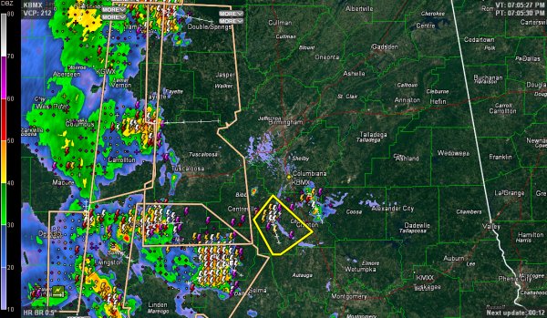
Here is the warning situation at 7:10:
Thunderstorms are occurring across much of western Alabama tonight from Franklin and Marion Counties across Lamar, Pickens, Sumter, Greene, Hale, Perry and Marengo Counties.
They are moving into Winston, Fayette, Tuscaloosa and Dallas Counties.
A severe thunderstorm warning that was in effect for parts of Sumter and Greene Counties until 730 p.m. has been canceled.
A separate severe thunderstorm is over the Chilton/Coosa County border northeast of Clanton, but it is weakening. The outflow from an earlier storm that triggered the Chilton/Coosa storm has triggered a new severe thunderstorm warning for Bibb and Chilton Counties.
There are significant weather alerts for all the areas outlined in the peach color. The severe thunderstorm warnings are shown in yellow.
The storms will slowly weaken as we lose the heating of the day and instability diminishes. But it looks like they will hold together enough to make it to I-65. The Tuscaloosa area got sort of lucky as that segment of the line sort of fell apart as it approached the Druid City. The storms are a little more than 90 minutes from the Birmingham Metro, putting them in here around 9 p.m.
Trees were reported down in Lamar County along highway 96 west of Millport and in the Detroit area. That was from those high winds that were well tracked by the Columbus Doppler radar. Great job NWS Birmingham on that early warning.
Category: Alabama's Weather, Severe Weather


