

10 a.m. Notes on Arthur: Hurricane Strengthening, Will be Cat 2
LATE REPORT – NEW VORTEX DATA MESSAGE
…Shows pressure continues to drop. Now 980 mb.
…The SFRM instrument estimated 66 knots surface wind (77 mph).
…Max flight level wind 79 knots (92 mph).
URNT12 KNHC 031518
VORTEX DATA MESSAGE AL012014
A. 03/15:02:50Z
B. 32 deg 25 min N
078 deg 39 min W
C. 700 mb 2906 m
D. 66 kt
E. 360 deg 0 nm
F. 297 deg 62 kt
G. 199 deg 18 nm
H. 980 mb
I. 13 C / 3046 m
J. 14 C / 3046 m
K. NA / NA
L. OPEN SW
M. C30
N. 12345 / 07
O. 0.02 / 3 nm
P. AF301 1101A ARTHUR OB 04
MAX FL WIND 62 KT 199 / 18 NM 14:57:00Z
MAX OUTBOUND FL WIND 79 KT 048 / 23 NM 15:10:00Z
MAX FL TEMP 16 C 179 / 13 NM FROM FL CNTR
ORIGINAL POST
The new advisory is out on Arthur. It has intensified to 90 mph. This is nearly a category two hurricane (threshold is 96 mph).

Click image to enlarge.
FAST FACTS 10 AM CDT
———————————————————
LOCATION…32.4N 78.5W
ABOUT 260 MI…415 KM SW OF CAPE HATTERAS NORTH CAROLINA
ABOUT 110 MI…175 KM SSW OF CAPE FEAR NORTH CAROLINA
MAXIMUM SUSTAINED WINDS…90 MPH…150 KM/H
PRESENT MOVEMENT…NNE OR 15 DEGREES AT 14 MPH…22 KM/H
MINIMUM CENTRAL PRESSURE…981 MB…28.97 INCHES
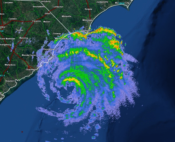
…Radar motion over the past 90 minutes or so seems to have been directly north. This is troubling, since all of the forecasts are showing a northeasterly turn. That northeasterly turn was very apparent early this morning with the recon fixes showing it clearly. The official track is to the NNE. The forward speed has increased to 14 mph.
…The central pressure continued to drop all morning. The last report from the plane was 983 mb at 6:26 a.m. CDT. The Air Force Hurricane Hunter plane is penetrating the center now. The NOAA3 P-3 Orion “Kermit” returned to base in Tampa for fuel. Seeing Kermit and Miss Piggy in recon reports always makes me smile.
…The P3 did measure a 91 knot max flight level wind (105 mph) at 8,000 feet.
…From the NWS Charleston: Good morning! The eye of Arthur is looking much more impressive over the past few radar volume scans, with an intense band of convection developing just northwest of the center. Buoy 41004 has been gusting to 45 knots with seas of 14 ft! It should be noted with seas that high, the buoy is likely not sampling the winds all that well and sustained winds could actually be closer to what the buoy is reporting as gusts.
…High surf and dangerous rip currents along the coast. Isle of Palms near Charleston reporting breaking waves 5-6 feet.
…A few observations from South Carolina:
…North Myrtle Beach 75F/73F with light rain/fog, SE-8 29.95R
…Mount Pleasant 77F/73F with drizzle, N 10 G 21, 29.81F
…Charleston 80F/73F with cloudy skies, N 16 G 23, 29.84F
…Folly Beach N 24 G 29
…Buoy (41 miles SE of Charleston) gusts to 52 mph
…Frying Pan Shoals Buoy is not available
…Coastal reports from the NWS Wilmington
OTHER MARINE REPORT
NATIONAL WEATHER SERVICE WILMINGTON NC
1107 AM EDT THU JUL 3 2014
…ALL SPEEDS IN KNOTS…
WIND AIR TEMP(F) WATER TEMP(F) STATION NAME
SSW 17 80 NA NORTH TOPSAIL BEACH
SE 11 72 82 WRIGHTSVILLE BEACH
ESE 5 74 M MASONBORO ISLAND
M M 74 85 WILMINGTON RIVERFRONT
CALM 0 74 NA WILMINGTON STATE PORT
NE 6 78 NA FORT FISHER
E 10 76 NA BALD HEAD ISLAND
ENE 8 75 NA SOUTHPORT
M M M NA OAK ISLAND
N 15 73 83 MYRTLE BEACH
N 8 73 84 GEORGETOWN
Category: Tropical
About the Author (Author Profile)
Bill Murray is the President of The Weather Factory. He is the site's official weather historian and a weekend forecaster. He also anchors the site's severe weather coverage. Bill Murray is the proud holder of National Weather Association Digital Seal #0001 @wxhistorianSubscribe
If you enjoyed this article, subscribe to receive more just like it.


