Strong Storms Developing
An all new edition of the ABC 33/40 Weather Xtreme video is available in the player on the right sidebar of the blog. You can subscribe to the Weather Xtreme video on iTunes by clicking here.
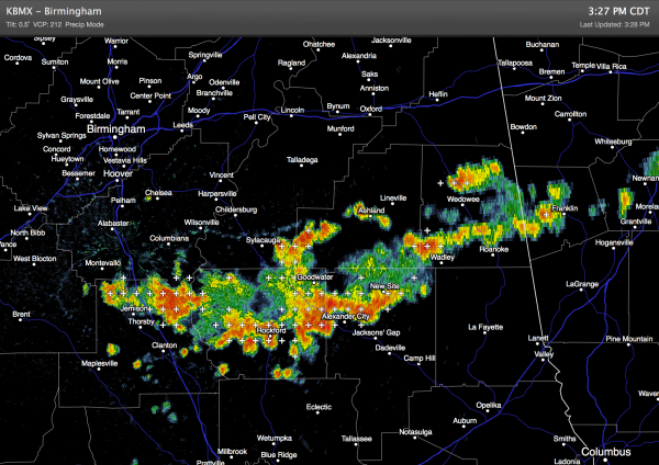
RADAR CHECK: A band of storms has fired up over Central Alabama on the outflow of the early morning thunderstorms that moved through the northern counties of the state. These storms are producing torrential rain, lots of lightning, and gusty winds.
Other storms are over West and North Alabama ahead of a surface front lined up near I-40 in Tennessee. Showers and storms will die down late tonight as the air becomes more stable.
TOMORROW: The front to the north will stall out somewhere near the Alabama/Tennessee border, so we will maintain the risk of scattered showers and thunderstorms with a mix of sun and clouds. The high will be somewhere between 87 and 90 degrees for most places.
FRIDAY AND THE WEEKEND: The front will dissipate, and an upper high will begin to build across the Deep South, meaning the weather will be hotter and drier. Just a small risk of any one spot seeing a shower or storm on these three day; the sky will be mostly sunny and hazy with highs up in the low 90s… some West Alabama communities could see mid 90s.
NEXT WEEK: The upper high shifts to the west, and with another surface front approaching from the north we expect a general increase in the number of shower and storms through at least the first half of the week. Highs should drop back into the upper 80s by Wednesday. See the Weather Xtreme video for the maps, graphics, and details.
GULF COAST WEATHER: We expect an increase in showers and storms tomorrow from Panama City to Gulf Shores, but there will still be some decent intervals of sunshine. Then, Friday through the weekend and into early next week, expect about 7 to 9 hours of sunshine each day with just a few widely scattered storms. Highs on the immediate coast will be in the upper 80s, and sea water temperatures are mostly in the mid 80s.
TROPICS: The Atlantic basin still looks very quiet and tropical storm formation is not expected through the weekend.
WEATHER BRAINS: Don’t forget you can listen to our weekly 90 minute netcast anytime on the web, or on iTunes. This is the show all about weather featuring many familiar voices, including our meteorologists here at ABC 33/40.
CONNECT: You can find me on all of the major social networks…
Facebook
Twitter
Google Plus
Instagram
I enjoyed seeing a big group today at the Double Springs Community Center in Winston County… be looking for the kids that were there on the Pepsi KIDCAM today at 5:00 on ABC 33/40 News! The next Weather Xtreme video will be posted here by 7:00 a.m. tomorrow….
Category: Alabama's Weather


