

Big Weather Changes Ahead
An all new edition of the ABC 33/40 Weather Xtreme video is available in the player on the right sidebar of the blog. You can subscribe to the Weather Xtreme video on iTunes by clicking here.
STILL HOT TODAY: We have a few small, isolated showers on radar at daybreak over East Alabama’s Calhoun, Cleburne, and Cherokee Counties… otherwise it is a warm, muggy morning with temperatures in the 70s. Look for a high in the low to mid 90s again today with a mix of sun and clouds… and like recent days a few storms could pop up during the heat of the day in widely scattered places.
COLD FRONT AHEAD: We sure don’t use the words “cold front” too often in mid-July, but a strong upper trough over the eastern U.S. will drive one down our way, and ahead of it we expect a good chance of showers and thunderstorms tonight and into part of the day tomorrow. The organized band of storms could enter the far northern part of Alabama around 6-7 p.m…. for North-Central Alabama (Tuscaloosa, Birmingham, Anniston, Gadsden), models hint the primary window for rain will come from 9:00 tonight through 12:00 noon tomorrow.
SPC has a “slight risk” of severe weather in place tonight for Tennessee, but the storms should be weakening as they move into North Alabama, and for now organized severe weather is not likely. Rain amounts of 1/2 to 1 inch are likely, but remember rain distribution with summer events is often not very even, so some could see more, and some could see less.
REFRESHING WEATHER WEDNESDAY AND THURSDAY: Drier, cooler air moves into the state tomorrow night, and we project lows in the 57-61 degree range at daybreak Wednesday and Thursday. Some of the cooler pockets across North Alabama could see low to mid 50s, something you surely don’t see often in the midst of summer around here.
For Birmingham… here are the record lows for mid-week
July 16 55 set in 1967
July 17 62 set in 1965
That July 17 record could be in danger early Thursday morning. Look for a mostly sunny sky Wednesday and Thursday with low humidity and a high in the mid 80s.
FRIDAY AND THE WEEKEND: More quick changes. Moist air will surge northward Thursday night, and these three days are looking relatively wet with occasional showers and thunderstorms. The sky will be generally cloudy with only a limited amount of sunshine.
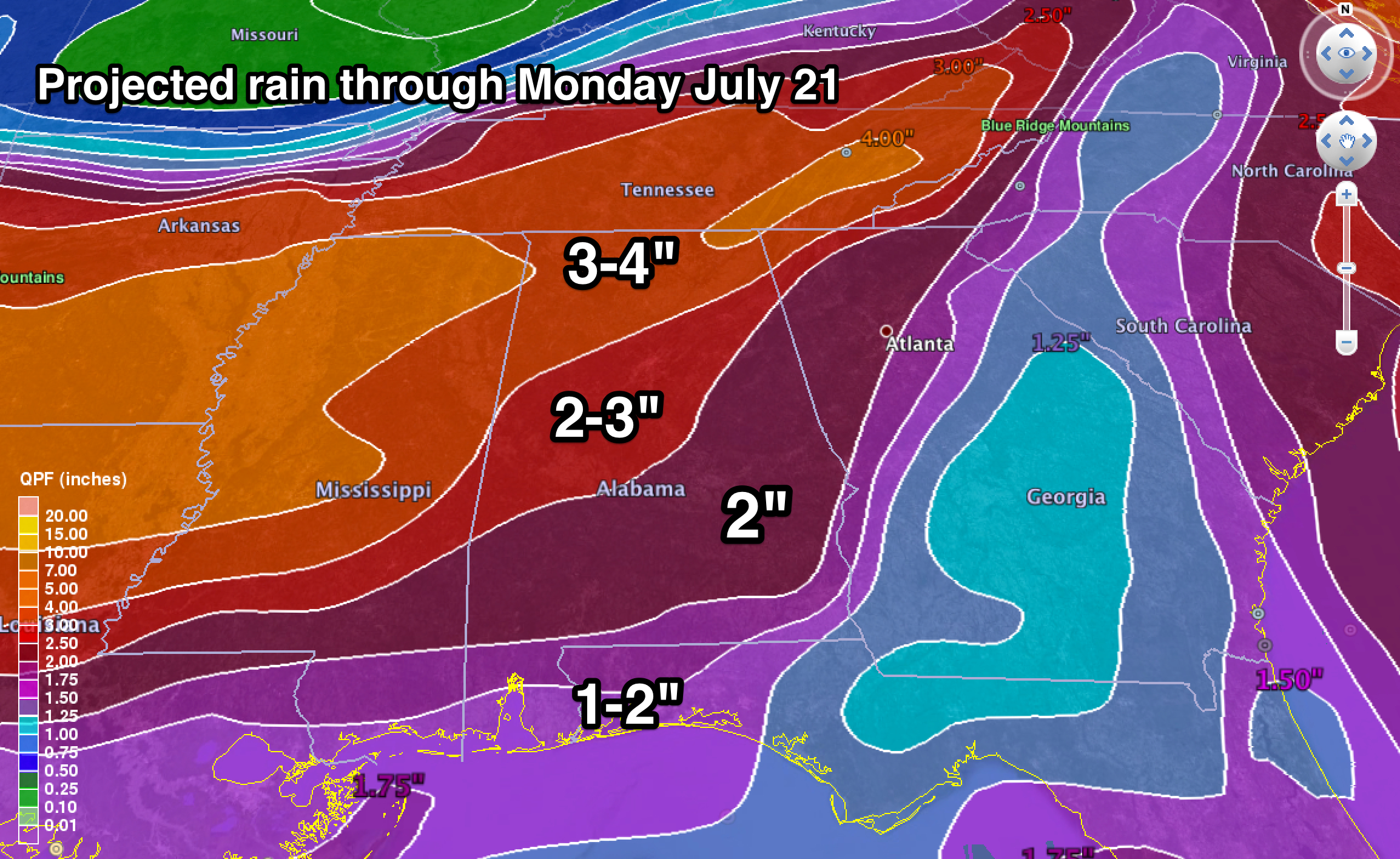
And, the wet pattern continues into early next week as a disturbed northwest flow aloft sets up across the Deep South. Average rain amounts over the next seven days over North Alabama will be in the two to four inch range…
See the Weather Xtreme video for the maps, graphics, and details.
GULF COAST WEATHER: Today will feature a mix of sun and clouds with scattered showers and thunderstorms from Panama City west to Gulf Shores… showers and storms will be more numerous tomorrow, then thinning out on Wednesday and Thursday with increasing amounts of sunshine. At this point the weather looks pretty routine Friday through Sunday on the coast, with about 6 to 8 hours of sunshine each day with the usual risk of scattered thunderstorms. Highs will remain mostly in the upper 80s on the immediate coast, and the sea water temperature early this morning at the Dauphin Island Sea Lab is 83 degrees.
Tropical storm formation is not expected across the Atlantic basin this week.
WEATHER BRAINS: Don’t forget you can listen to our weekly 90 minute netcast anytime on the web, or on iTunes. This is the show all about weather featuring many familiar voices, including our meteorologists here at ABC 33/40. We will produce this week’s show tonight at 8:30 CT… you can watch it on “James Spann 24/7” on cable systems around the state, or on the web here.
CONNECT: You can find me on all of the major social networks…
Facebook
Twitter
Google Plus
Instagram
I will be doing a weather talk today for kids in a summer program at Clay Elementary School… look for the next Weather Xtreme video here by 4:00 this afternoon. Enjoy the day!
Category: Alabama's Weather
About the Author (Author Profile)
James Spann is one of the most recognized and trusted television meteorologists in the industry. He holds the AMS CCM designation and television seals from the AMS and NWA. He is a past winner of the Broadcast Meteorologist of the Year from both professional organizations.Subscribe
If you enjoyed this article, subscribe to receive more just like it.


