Wet Weather Ahead For Alabama
An all new edition of the ABC 33/40 Weather Xtreme video is available in the player on the right sidebar of the blog. You can subscribe to the Weather Xtreme video on iTunes by clicking here.
ANOTHER “COOL” JULY DAY: Temperatures are mostly in the 78-82 degree range this afternoon across the great state of Alabama… it doesn’t look or feel like mid-July. Mid level clouds have been increasing this afternoon, but the low levels are dry with low dew points.
RAIN ON THE WAY: Lots of rain today to the west of Alabama… there was some serious flash flooding north of Dallas/Fort Worth along I-35 earlier today, and rain is widespread around the Ark-La-Tex region this afternoon. The wave responsible for the rain is slowly moving our way, and it looks like rain and storms could very well become widespread tomorrow. Some communities across North Alabama might not make it out of the 70s tomorrow because of the clouds and rain. Some thunder is possible, but no severe weather.
OUR WEEKEND: The axis of deeper moisture stays in place, and we will continue to forecast occasional showers and thunderstorms Saturday and Sunday. There will be some decent breaks in the rain, but just understand rain is possible at any hour on both days with only a limited amount of sun. Highs over the weekend will be in the low to mid 80s. Three day rain totals (tomorrow through Sunday) will be in the 2 inch range.
NEXT WEEK: Dynamic support will weaken a bit, but moist air stays in place, so we will continue with the mention of at least scattered showers and thunderstorms Monday through Wednesday… temperatures will trend back up toward 90 degrees by mid-week. Some evidence that a surface front approaching from the north could bring another increase in the number of showers and thunderstorms late in the week. See the Weather Xtreme video for the maps, graphics, and details.
GULF COAST WEATHER: We project about 5 to 7 hours of sunshine each day tomorrow through Sunday from Panama City west to Gulf Shores, with the daily risk of scattered thunderstorms. Highs will remain in the upper 80s along the immediate coast, with sea water temperatures in the low to mid 80s.
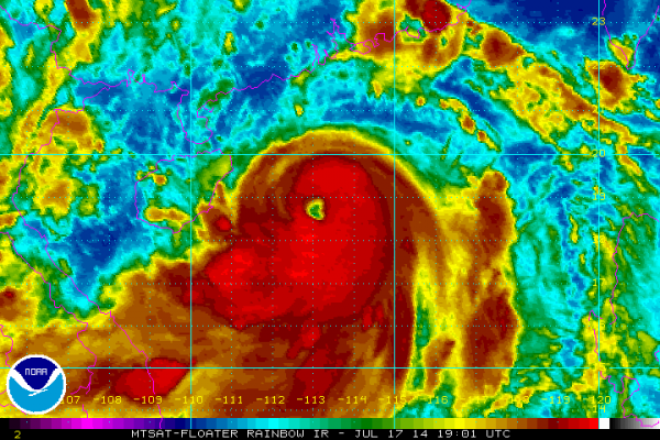
TROPICS: The Atlantic basin remains quiet, but over in the western Pacific Typhoon Rammasun now has sustained winds to 140 mph, a category 4.? It will move into China in a few days, but it will be in a weakening phase by then.
WEATHER BRAINS: Don’t forget you can listen to our weekly 90 minute netcast anytime on the web, or on iTunes. This is the show all about weather featuring many familiar voices, including our meteorologists here at ABC 33/40.
CONNECT: You can find me on all of the major social networks…
Facebook
Twitter
Google Plus
Instagram
I enjoyed seeing a big group of home schoolers today at Cullman’s First Baptist Church… be looking for them on the Pepsi KIDCAM this evening on ABC 33/40 News at 6:00! The next Weather Xtreme video will be posted here by 7:00 a.m. tomorrow….
Category: Alabama's Weather


