Wet/Cool Friday For Much Of Alabama
An all new edition of the ABC 33/40 Weather Xtreme video is available in the player on the right sidebar of the blog. You can subscribe to the Weather Xtreme video on iTunes by clicking here.
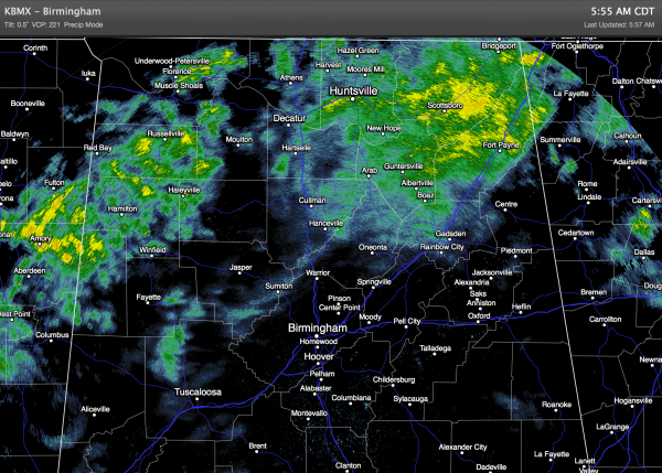
RAIN RETURNS: At daybreak rain covers much of North Alabama, and today looks like a cloudy, wet, and relatively cool day for our state. Birmingham’s record low maximum temperature for July 18 is 79 degrees set in 1906, and that 108 year old record is in danger due to clouds and rain.
THE ALABAMA WEEKEND: An axis of deeper moisture will linger over the state, but the dynamic support will weaken. So, showers and thunderstorms remain possible tomorrow and Sunday, but the rain won’t be continuous, and the sun will be out at times. In fact, the latest model data hints that the showers could be pretty scattered in nature by Sunday. The high will return to the mid 80s tomorrow, followed by upper 80s Sunday.
NEXT WEEK: The pattern returns to a more routine one for mid-summer. An upper high will be anchored west of the state, and around here we project partly sunny days with the risk of “scattered, mostly afternoon and evening showers and thunderstorms”. The high will be close to 90 degrees on both days.
The GFS suggests a surface front could bring a better coverage of showers and thunderstorms by Thursday, with drier air for the northern third of the state Friday of next week… see the Weather Xtreme video for the maps, graphics, and details.
GULF COAST WEATHER: Only a limited amount of sun for the coast from Panama City to Gulf Shores today and tomorrow with a few showers and thunderstorms likely. Then, rather routine summer weather Sunday into much of next week, with about 6 to 8 hours of sunshine each day with a few scattered thunderstorms around. Highs will be in the mid 80s today and tomorrow, with upper 80s Sunday through next week along the immediate coast. The sea water temperature early this morning at the Dauphin Island Sea Lab is 80 degrees.
TROPICS: The Atlantic basin remains quiet, but over in the western Pacific the eye wall of Super Typhoon Rammasun is moving into Hainan Island and Leizhou Peninsula of China with sustained winds of near 150 mph.?
WEATHER BRAINS: Don’t forget you can listen to our weekly 90 minute netcast anytime on the web, or on iTunes. This is the show all about weather featuring many familiar voices, including our meteorologists here at ABC 33/40.
CONNECT: You can find me on all of the major social networks…
Facebook
Twitter
Google Plus
Instagram
Look for the next Weather Xtreme video here by 4:00 or so this afternoon. Enjoy the day!
Category: Alabama's Weather


