

Moist Air Stays In Place Over The Weekend
An all new edition of the ABC 33/40 Weather Xtreme video is available in the player on the right sidebar of the blog. You can subscribe to the Weather Xtreme video on iTunes by clicking here.
COOLEST JULY 18 ON RECORD: At 2:00 this afternoon Haleyville, in Northwest Alabama’s Winston County, was reporting only 64 degrees… that is 27 degrees below average…
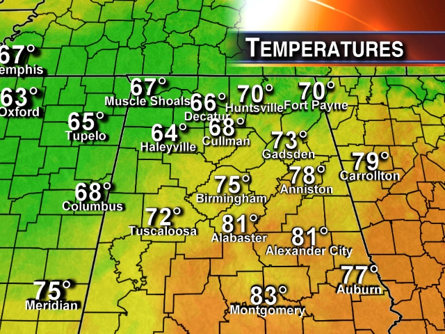
Looks like Birmingham will easily break the old record low maximum temperature for July 18… we are in the mid 70s at 3:00… the old record maximum for today was 79 set in 1906.
Clouds and widespread rain are over Alabama today, helping to keep temperatures in record territory. The heaviest rain has been over the northern and western counties, where some places have received over one inch of beneficial rain.
THE ALABAMA WEEKEND: Dynamic support for rain will weaken over the weekend, meaning showers and thunderstorms will become more scattered in nature. Some of the high resolution models actually suggest our best chance of rain tomorrow will come during the morning hours, but an afternoon shower or storm is certainly possible as well. The sun might peek out at times tomorrow, and the weather will be warmer with a high back in the mid 80s.
Sunday should be brighter and drier with a mix of sun and clouds and a few scattered showers and thunderstorms. The high Sunday should be up in the mid to upper 80s as we dig out of the “July deep freeze”.
NEXT WEEK: The weather looks pretty routine for the first half of the week… partly sunny Monday through Wednesday with the usual risk of “scattered, mostly afternoon and evening showers and thunderstorms”. Highs should be in the 87 to 90 degree range. The is potential for an increase in showers and storms over the latter half of the week with a surface boundary approaching from the north…. see the Weather Xtreme video for maps, graphics, and details.
GULF COAST WEATHER: A few showers and storms are likely tomorrow with only a limited amount of sunshine, but look for improving conditions Sunday and into next week with about 6 to 8 hours of sunshine each day along with a few scattered thunderstorms. Highs tomorrow will be in the mid 80s, with upper 80s Sunday through much of next week along the immediate coast from Panama City over to Gulf Shores. Sea water temperatures are mostly in the low 80s.
TROPICS: The Atlantic basin is still very quiet, and tropical storm formation is not expected through the weekend.
WEATHER BRAINS: Don’t forget you can listen to our weekly 90 minute netcast anytime on the web, or on iTunes. This is the show all about weather featuring many familiar voices, including our meteorologists here at ABC 33/40.
CONNECT: You can find me on all of the major social networks…
Facebook
Twitter
Google Plus
Instagram
Look for my next Weather Xtreme video Monday morning by 7:00…. Brian Peters will have the video updates tomorrow and Sunday. Enjoy the weekend!
Category: Alabama's Weather
About the Author (Author Profile)
James Spann is one of the most recognized and trusted television meteorologists in the industry. He holds the AMS CCM designation and television seals from the AMS and NWA. He is a past winner of the Broadcast Meteorologist of the Year from both professional organizations.Subscribe
If you enjoyed this article, subscribe to receive more just like it.


