

Sunday Afternoon Update
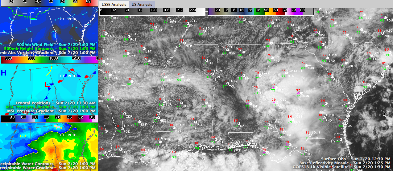
An area of showers and storms has been moving across South Central Alabama this morning and early afternoon in response to a very weak surface low moving moving across southern Alabama. The mesoscale models picked up on this feature very well yesterday and predicted there would be showers this morning in places like Clanton, Montgomery, Greenville and Auburn.
Click image to enlarge.
Mostly rainfall amounts were moderate, although there were some 3 to 4 inch amounts in places like northern Bullock, Lee, western Lowndes and southeastern Dallas Counties. Auburn has picked up 1.67 inches since yesterday morning.
There was a good bit of lightning in the I-85 corridor.
The heaviest weather is now exiting northeastward into Georgia, around the Lanett/Valley exit on I-85.

ON THE WEATHER MAPS: In addition to the surface low northeast of Montgomery, a stationary front lies generally along I-59 and most of any shower activity that develops through the afternoon should be east of this boundary. In the mid levels of the atmosphere, a powerhouse of a high is near El Paso. To the right of it, a series of disturbances is rounding the top of the high, carving out a trough over the Ohio Valley down into the Tennessee Valley. One of the disturbances was sliding into northern Mississippi and we are tracking another over southwestern Missouri.
TROFFY PATTERN: Is “troffy” a word? For our purposes it is. Those kinds of disturbances will keep us in a troffy pattern into the coming work week. In fact, the trough may close off into an upper level low by Tuesday, which could lead to increase rain chances Tuesday and Wednesday. For today, drier air covers the northern half of the state, reducing shower chances to around 10-20%. Moisture levels will rebound a bit on Monday, allowing rain chances to return to 20-30%. If the upper low materializes as expected by Tuesday, rain chances will likely undergo an uptick. This increase in rain chances should continue into Wednesday.
TEMPS: Highs today will be generally in the upper 80s, except over East Central Alabama, where clouds and showers are limiting the rise in the mercury. By tomorrow, everyone should be in the upper 80s and this trend should continue through midweek, except there will be an increasing number of 90s thrown in each day.
Category: Alabama's Weather
About the Author (Author Profile)
Bill Murray is the President of The Weather Factory. He is the site's official weather historian and a weekend forecaster. He also anchors the site's severe weather coverage. Bill Murray is the proud holder of National Weather Association Digital Seal #0001 @wxhistorianSubscribe
If you enjoyed this article, subscribe to receive more just like it.


