Drier Air Arrives Friday
An all new edition of the ABC 33/40 Weather Xtreme video is available in the player on the right sidebar of the blog. You can subscribe to the Weather Xtreme video on iTunes by clicking here.
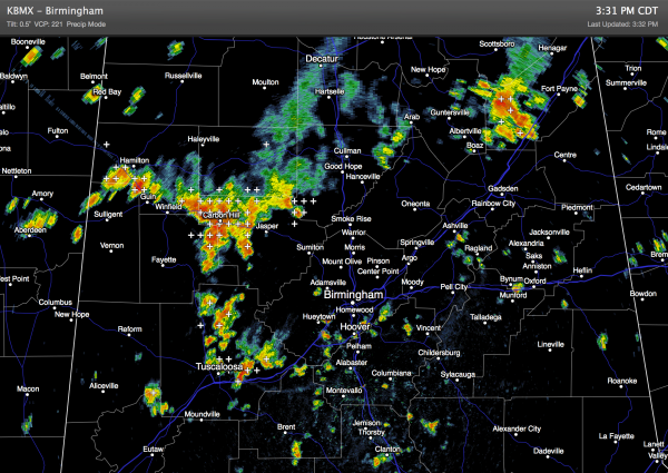
SLOW MOVING SUMMER STORMS: Some communities across the northern half of Alabama have received some big rain totals today due to nearly stationary thunderstorms; the NWS in Huntsville issued a number of flash flood warnings for their counties up in the Tennessee Valley.
We will maintain the chance of a few showers and storms across Alabama through the night as a surface front approaches from the north.
That front will also mean a good chance of showers and thunderstorms tomorrow; organized severe weather is not expected, although a few storms are certainly possible, much like today. Tomorrow should be the 10th consecutive day with a high below 90 degrees in Birmingham.
FRIDAY AND SATURDAY: Drier air moves down into North Alabama, and these two days should be mostly rain-free for the northern half of the state. Scattered storms will be confined to South Alabama, and our highs will be pretty close to 90 degrees.
A cold front, supported by a deepening upper trough over the eastern third of the nation, will move into Alabama late Sunday or early Monday. The 12Z run of the GFS hints the best chance of showers and storms along the front could very well be from about 9 p.m. Sunday through 9:00 a.m. Monday. Drier air will begin flowing into North Alabama Monday afternoon.
ANOTHER REFRESHING AIRMASS: Here we go again… potential for more record lows across Alabama by Wednesday morning of next week. Highs drop into the low to mid 80s Tuesday and Wednesday with low humidity, and it looks like a low early Wednesday between 58 and 62 (the record low for July 30 is 61, set in 1994). This cool airmass will come at a time when summer heat is typically at it’s peak. See the Weather Xtreme video for maps, graphics, and more details.
TROPICS: Tropical depression two dissipated earlier today in the Atlantic, and with very dry air covering much of the Atlantic basin, tropical storm formation is not expected anytime soon.
GULF COAST WEATHER: Not bad at all. We project about 7 to 9 hours of sunshine each day from panama City to Gulf Shores through the weekend with only widely scattered storms each day. Highs in the mid to upper 80s on the immediate coast, with sea water temperatures mostly in the mid 80s.
WEATHER BRAINS: Don’t forget you can listen to our weekly 90 minute netcast anytime on the web, or on iTunes. This is the show all about weather featuring many familiar voices, including our meteorologists here at ABC 33/40.
CONNECT: You can find me on all of the major social networks…
Facebook
Twitter
Google Plus
Instagram
I had a great time today visiting the kids at the Children’s Library in Alexander City… be looking for them on the Pepsi KIDCAM today at 5:00 on ABC 33/40 News! The next Weather Xtreme video will be posted here by 7:00 a.m. tomorrow.
Category: Alabama's Weather


