

Turning Cooler Tonight
An all new edition of the ABC 33/40 Weather Xtreme video is available in the player on the right sidebar of the blog. You can subscribe to the Weather Xtreme video on iTunes by clicking here.
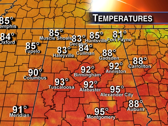
COOLER AIR MOVING INTO NORTH ALABAMA: Temperatures are only in the low 80s over the northeast corner of Alabama this afternoon, and the dew point has dropped to 55 at Fort Payne, where they have a fresh north breeze gusting to 21 mph.
This cooler, drier air will keep moving southward tonight. And, to the south, along the cold front, strong to severe showers and thunderstorms have formed over South Alabama. A number of severe thunderstorm warnings have been posted for counties between Mobile and Montgomery… the main threat is from strong, gusty winds.
TOMORROW AND WEDNESDAY: What a nice fall preview. Low humidity levels, sunny days, cool nights. Highs in the mid 80s, and the low early Wednesday will be close to 60, with 50s for the cooler pockets. A number of new record lows are likely Wednesday (Birmingham’s record low for July 30 is 61 set in 1994). It will feel more like late September instead of late July.
THURSDAY/FRIDAY: Moisture returns, and we will mention the risk of an afternoon shower or thunderstorm Thursday. Scattered showers and storms are possible Friday with a mix of sun and clouds; highs will be in the mid to upper 80s.
THE ALABAMA WEEKEND: A pool of low level moisture will be in place, so there will be a risk of scattered showers and thunderstorms both Saturday and Sunday. Not a continuous kind of rain, but if you have something planned outdoors just understand a passing shower or storm is possible at just about anytime. The sky will be occasionally cloudy, and highs will hold in the mid to upper 80s.
Expect similar weather early next week… see the Weather Xtreme video for maps, graphics, and details.
TROPICS: A well organized tropical wave in the eastern Atlantic should become Tropical Storm Bertha later this week; most models recurve this into the open Atlantic before impacting the U.S. mainland.
GULF COAST WEATHER: A strong storm is likely in a number of spots along the coast tonight from Panama City to Gulf Shores… then beautiful weather tomorrow and Wednesday with sunny days and fair nights. Then, Thursday through the weekend, about 6 to 8 hours of sunshine each day with a few scattered showers and storms. Highs will remain mostly in the mid to upper 80s along the coast, and sea water temperatures are in the mid 80s in most places.
WEATHER BRAINS: Don’t forget you can listen to our weekly 90 minute netcast anytime on the web, or on iTunes. This is the show all about weather featuring many familiar voices, including our meteorologists here at ABC 33/40. We will produce this week’s show tonight at 8:30 CT… you can watch it on “James Spann 24/7” on cable systems around the state, or on the web here.
CONNECT: You can find me on all of the major social networks…
Facebook
Twitter
Google Plus
Instagram
I enjoyed seeing the kids in the Alabaster City Schools summer program today at Meadow View Elementary… be looking for them on the Pepsi KIDCAM today at 5:00 on ABC 33/40 News. The next Weather Xtreme video will be posted here by 7:00 a.m. tomorrow….
Category: Alabama's Weather
About the Author (Author Profile)
James Spann is one of the most recognized and trusted television meteorologists in the industry. He holds the AMS CCM designation and television seals from the AMS and NWA. He is a past winner of the Broadcast Meteorologist of the Year from both professional organizations.Subscribe
If you enjoyed this article, subscribe to receive more just like it.


