

Moisture Levels Begin To Rise Tomorrow
An all new edition of the ABC 33/40 Weather Xtreme video is available in the player on the right sidebar of the blog. You can subscribe to the Weather Xtreme video on iTunes by clicking here.
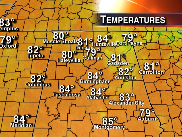
FINE SUMMER DAY: After record lows this morning (as cool as 50 degrees at Black Creek, near Gadsden), temperatures are mostly in the low to mid 80s across North/Central Alabama this afternoon. The sky is mostly sunny, and humidity levels remain low.
TOMORROW/FRIDAY: We are watching with interesting an MCV (mesoscale convective vortex) type feature on the Arkansas/Oklahoma border, moving southeast. The NAM has identified this feature, and moves rain into Northwest Alabama early tomorrow morning. The GFS model, however, remains rather dry and shows the rain mostly dissipating before reaching our state. Based on radar trends, I do think we will need to mention a chance of showers tomorrow, but the air over the state is relatively dry, so amounts should be mostly light and spotty. The high tomorrow will be in the mid 80s with a mix of sun and clouds.
Moisture levels will be deeper Friday, so scattered showers and thunderstorms are possible.
THE ALABAMA WEEKEND: An axis of deeper moisture will be in place as the weekend begins, so for now Saturday looks like a day with more clouds than sun, and scattered to numerous showers and thunderstorms along with a high in the low to mid 80s. Showers and storms are still possible Sunday, although they should thin out a bit with temperatures rising into the upper 80s.
NEXT WEEK: Confidence is low since there is not much consistency in model output; looks like we will need to continue to some of scattered showers and storms through at least the first half of the week, with daily highs between 87 and 90 degrees. See the Weather Xtreme video for maps, graphics, and more details.
GULF COAST WEATHER: Mostly sunny weather tomorrow with only a small risk of a shower from Panama City west to Gulf Shores; the high will be in the upper 80s. Then, about 6 to 8 hours of sunshine each day Friday through Sunday with a daily possibility of scattered showers and storms.
TROPICAL WEATHER: The tropical wave in the Atlantic between Africa and the Lesser Antilles is still struggling; there is little deep convection this afternoon as it moves west/northwest. Seems like dry air surrounding the system, and wind shear is preventing it from becoming better organized. NHC has dropped the chance of development from 70 to 50 percent, and if anything can form in that region most likely it recurves before reaching the U.S. See the Weather Xtreme video for the maps.
WEATHER BRAINS: Don’t forget you can listen to our weekly 90 minute netcast anytime on the web, or on iTunes. This is the show all about weather featuring many familiar voices, including our meteorologists here at ABC 33/40.
CONNECT: You can find me on all of the major social networks…
Facebook
Twitter
Google Plus
Instagram
I will be taking a little vacation time… my next Weather Xtreme video will be posted here Friday morning, August 8 by 7:30. Brian Peters will handle the videos tomorrow through August 7…
Category: Alabama's Weather
About the Author (Author Profile)
James Spann is one of the most recognized and trusted television meteorologists in the industry. He holds the AMS CCM designation and television seals from the AMS and NWA. He is a past winner of the Broadcast Meteorologist of the Year from both professional organizations.Subscribe
If you enjoyed this article, subscribe to receive more just like it.


