

Here Comes The Summer Heat
An all new edition of the ABC 33/40 Weather Xtreme video is available in the player on the right sidebar of the blog. You can subscribe to the Weather Xtreme video on iTunes by clicking here.
HOT IS THE WORD: An upper high will build across the Deep South in coming days, and will set up the hottest 7 day period we have seen so far this summer. We did reach 99 degrees in Birmingham back on August 7, but it was pretty much one and done.
We are forecasting a high in the mid 90s today, followed by upper 90s tomorrow through the weekend. Humidity levels will be high, and the heat will be oppressive. I won’t insult your intelligence with “heat tips”, but it will be pretty tough if you have to work outside during the heat of the day.
STORMS? Yes, there is the risk of thunderstorm on almost any hot, humid summer afternoon in Alabama, but the warmer air aloft associated with the upper high means they will be few and far between. If you manage to see a cooling shower or storm, be thankful.
NEXT WEEK: Heat levels will drop slowly as the upper high weakens and the air aloft become colder… also expect a slow increase in the number of “scattered afternoon thunderstorms”. Highs, however, will still hold in the 90s at least for the first half of the week.
GULF COAST WEATHER: Mostly sunny days, fair nights, and only isolated storms for the area from Panama City west to Gulf Shores through the weekend. Highs along the immediate coast 87 to 90, with mid to upper 90s inland. The sea water temperature early this morning at the Dauphin Island Sea Lab is 85 degrees.
TROPICS: The National Hurricane Center is monitoring two weak, disorganized waves over the Atlantic. The lead wave has the best chance of some development, and it will move into the eastern Caribbean Friday. Scam artists on social media are showing scary graphics predicting a major hurricane on the Gulf Coast for Labor Day weekend, and begging people to “share” across Facebook. I ask that you don’t participate in the scam… NOBODY knows the placement or intensity of a tropical cyclone 7 to 10 days in advance.
Most tropical models move the system up toward the southern coast of Hispaniola and Cuba in 4-5 days, but it remains to be seen if this can develop at all due to dry air, and interaction with the mountains on the island of Hispaniola.
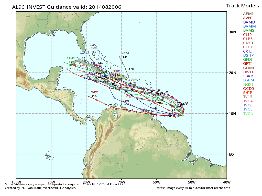
The spread on global models is 1500 miles toward the end of next week. The GFS moves it to a point north of Galveston, the Canadian global model recurves it into the Atlantic, while the European model has a weak system near New Orleans. See the Weather Xtreme video for the maps and graphics.
We do note the Gulf of Mexico is warm, with SSTs of over 30 degrees (C) in many areas, so if by chance something goes get in there, rapid intensification is possible. We will watch closely in coming days, but if you have a Labor Day beach trip planned, there is absolutely no need to “panic” or change plans. Nobody knows now.
WEATHER BRAINS: Don’t forget you can listen to our weekly 90 minute netcast anytime on the web, or on iTunes. This is the show all about weather featuring many familiar voices, including our meteorologists here at ABC 33/40.
CONNECT: You can find me on all of the major social networks…
Facebook
Twitter
Google Plus
Instagram
I will be speaking today at the Boaz Rotary Club in Marshall County… look for the next Weather Xtreme video here by 4:00 this afternoon. Enjoy the day…
Category: Alabama's Weather
About the Author (Author Profile)
James Spann is one of the most recognized and trusted television meteorologists in the industry. He holds the AMS CCM designation and television seals from the AMS and NWA. He is a past winner of the Broadcast Meteorologist of the Year from both professional organizations.Subscribe
If you enjoyed this article, subscribe to receive more just like it.


