

Not As Hot This Week
An all new edition of the ABC 33/40 Weather Xtreme video is available in the player on the right sidebar of the blog. You can subscribe to the Weather Xtreme video on iTunes by clicking here.
RADAR CHECK: One lone shower was over Alabama at daybreak over West Alabama’s Pickens County, moving southwest into Mississippi. We will continue to mention a risk of scattered storms today, but they should be most numerous over the western half of the state, where deeper moisture is in place. The chance of any one spot getting wet west of I-65 today is about one in three. The high will be close to 90 degrees; some places won’t make it out of the 80s.
MID-WEEK: Drier air moves into Alabama from the east tonight, and we will be dry tomorrow through Thursday with sunny days, fair cooler nights, and lower humidity levels. Highs will be close to 90 degrees, but morning lows will drop into the 60s. Coolest morning should come early Wednesday with mid 60s likely… we just might see a few upper 50s across the cooler pockets of Northeast Alabama.
FRIDAY AND THE LABOR DAY WEEKEND: Moist air begins to return Friday, and a few spots could see an afternoon shower or thunderstorm. Then, for the holiday weekend, we project a mix of sun and clouds Saturday through Monday with the daily risk of “scattered showers and thunderstorms”. This doesn’t imply a “wash out” or “rainy weekend”, but no doubt we will deal with a few passing storms along the way. Highs over the weekend will be in the 88 to 91 degree range, about average for late August and early September in Alabama. See the Weather Xtreme video for the maps, graphics, and more details.
GULF COAST WEATHER: We project mostly sunny days and fair nights on the coast from Panama City to Gulf Shores through Thursday. For the Labor Day weekend, about 5 to 7 hours of sunshine each day in this zone with the daily risk of scattered thunderstorms. Highs along the immediate coast will be in the 88-92 degree range, and the sea water temperature early this morning at the Pensacola Beach is 87 degrees.
TROPICS: Tropical Storm Cristobal, over the Southeast Bahamas, is expected to become a hurricane tomorrow night, but it will recurve into the Atlantic and is no threat to the U.S.
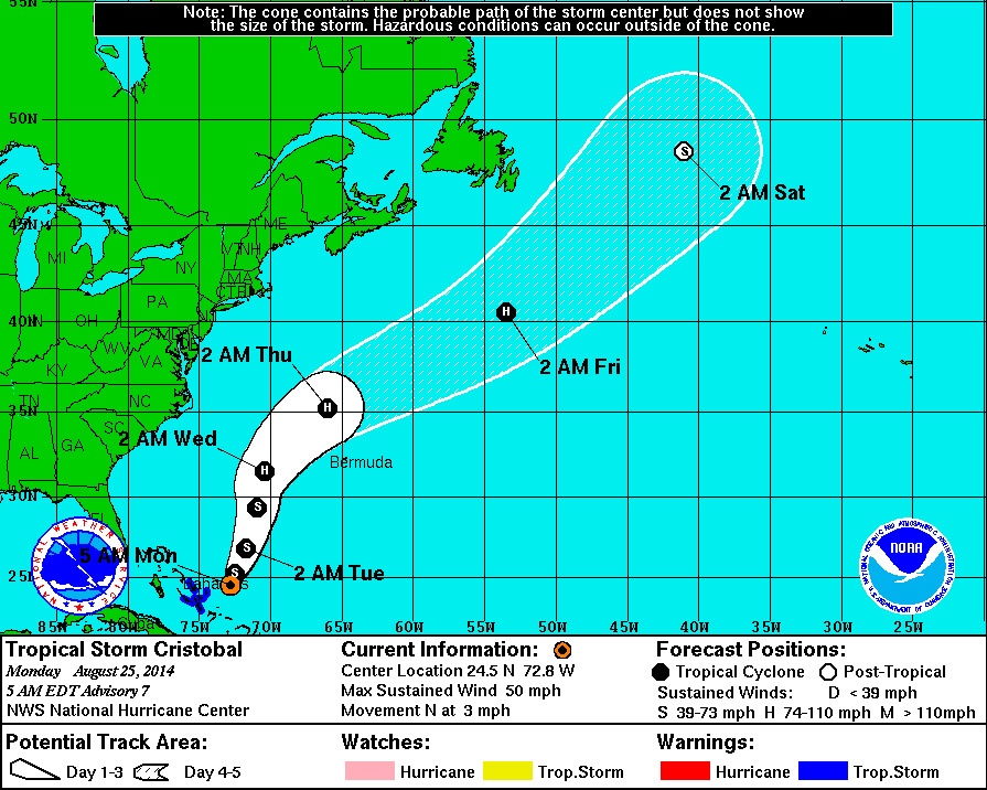
A tropical wave is over the Atlantic between Africa and the Lesser Antilles; some chance of slow development later this week.
And, in the Pacific, Hurricane Marie is packing sustained winds of 145 mph well off the coast of Mexico, but this will weaken quickly over cooler water in coming days as it moves north/northwest. Swells and rough surf from this will impact the Southern California coast later this week. See the Weather Xtreme video for more details.
WEATHER BRAINS: Don’t forget you can listen to our weekly 90 minute netcast anytime on the web, or on iTunes. This is the show all about weather featuring many familiar voices, including our meteorologists here at ABC 33/40. We will produce this week’s show tonight at 8:30 CT… you can watch it on “James Spann 24/7” on cable systems around the state, or on the web here.
CONNECT: You can find me on all of the major social networks…
Facebook
Twitter
Google Plus
Instagram
Look for the next Weather Xtreme video here by 4:00 this afternoon… enjoy the day…
Category: Alabama's Weather
About the Author (Author Profile)
James Spann is one of the most recognized and trusted television meteorologists in the industry. He holds the AMS CCM designation and television seals from the AMS and NWA. He is a past winner of the Broadcast Meteorologist of the Year from both professional organizations.Subscribe
If you enjoyed this article, subscribe to receive more just like it.


