

Dry Air Settles Into Alabama
An all new edition of the ABC 33/40 Weather Xtreme video is available in the player on the right sidebar of the blog. You can subscribe to the Weather Xtreme video on iTunes by clicking here.
RADAR CHECK: Nothing showing up on the radar at mid-afternoon across the great state of Alabama. We will maintain the risk of scattered storms over the western counties through the evening hours, but drier air continues to work here from the east, and will set the stage for rain-free weather through mid-week.
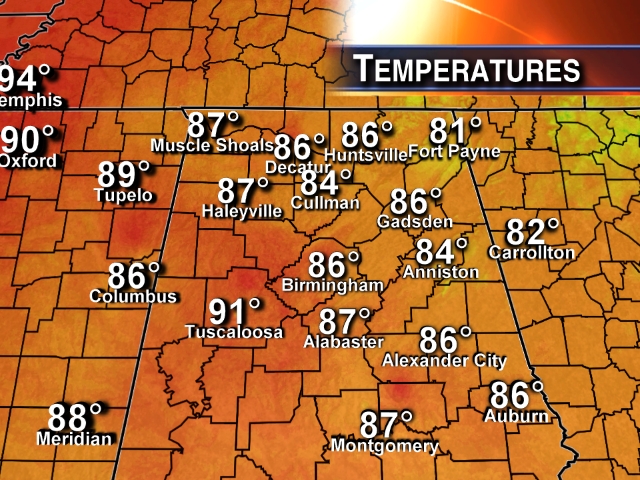
Heat levels, as expected, are considerably lower across the state today, with readings mostly in the 85 to 90 degree range.
MID-WEEK: Mostly sunny days, fair nights, and lower humidity levels tomorrow through Thursday. Highs around 90; lows in the 60s. Coolest morning will come early Wednesday with mid 60s for most communities; cooler pockets over Northeast Alabama might make a run at the upper 50s.
FRIDAY AND THE LABOR DAY WEEKEND: Moisture levels begin to rise Friday, and a few spots could see an afternoon shower or thunderstorm. Then, for the holiday weekend, we are forecasting a mix of sun and clouds each day Saturday through Monday with scattered showers and thunderstorms. This won’t be a “wash out”, but if you have something planned outdoors just be aware that you will deal with a passing shower or storm from time to time, especially during the afternoon and evening hours. Highs will be in the 87 to 90 degree range. See the Weather Xtreme video for maps, graphics, and more details.
GULF COAST WEATHER: Mostly sunny days, fair nights through Thursday from Panama City over to Gulf Shores. Then, for Friday and the Labor Day weekend, about 5 to 7 hours of sunshine each day with the usual risk of scattered thunderstorms. The only potential fly in the ointment is the disturbance over the northern Gulf of Mexico; for now it is very disorganized, but we will keep an eye on it.
TROPICS: Tropical Storm Cristobal looks very unhealthy with the circulation center pretty much exposed; it is just east of the Bahamas. It will move north, and then northeast, staying away from the U.S. this week, but NHC still expects it to become a minimal hurricane by Wednesday between the U.S. Atlantic coast and Bermuda.
A disturbance in the Atlantic between the coast of Africa and the Lesser Antilles has some potential for slow development later this week, but dry air surrounds the system and it looks very disorganized for now. It should be near, or north of Puerto Rico this weekend. Too early to determine if this will recurve into the open Atlantic, or keep trucking toward the Southeast U.S.
Over in the East Pacific, Hurricane Marie is packing sustained winds of 140 mph, but will weaken as it moves northwest. Still, swells and rough surf will impact the coasts of Baja California and Southern California later this week. See the Weather Xtreme video for the maps and graphics concerning the tropical weather situation.
WEATHER BRAINS: Don’t forget you can listen to our weekly 90 minute netcast anytime on the web, or on iTunes. This is the show all about weather featuring many familiar voices, including our meteorologists here at ABC 33/40. We will produce this week’s show tonight at 8:30 CT… you can watch it live on “James Spann 24/7” on cable systems around the state, or on the web here.
CONNECT: You can find me on all of the major social networks…
Facebook
Twitter
Google Plus
Instagram
Look for the next Weather Xtreme video here by 7:00 a.m. tomorrow….
Category: Alabama's Weather
About the Author (Author Profile)
James Spann is one of the most recognized and trusted television meteorologists in the industry. He holds the AMS CCM designation and television seals from the AMS and NWA. He is a past winner of the Broadcast Meteorologist of the Year from both professional organizations.Subscribe
If you enjoyed this article, subscribe to receive more just like it.


