

Eyes On The Front To The North
An all new edition of the ABC 33/40 Weather Xtreme video is available in the player on the right sidebar of the blog. You can subscribe to the Weather Xtreme video on iTunes by clicking here.
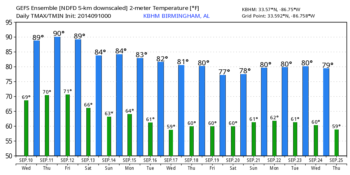
VERY WARM, VERY HUMID THROUGH FRIDAY: Alabama’s weather won’t change much today; partly sunny, very warm, and very humid with only isolated showers or storms this afternoon and early tonight. Afternoon storms could be a little more active tomorrow, especially over the northern third of the state. Afternoon highs will remain generally in the 87 to 90 degree range, just above seasonal averages (today’s average high in Birmingham is 86.
The much discussed cold front to the north of Alabama should bring a band of organized storms down into the Tennessee Valley of extreme North Alabama tomorrow night, but the front will begin to lose it’s southward push as the main dynamic support stays to the north. On Friday, we stay in a warm, muggy airmass, and this could very well be the day with the best coverage of showers and storms with the front over Tennessee. It won’t rain all day Friday, and the sun could be out at times, but a shower or storm will be possible at just about any hour. The high Friday will drop into the mid 80s.
COMPLICATED WEEKEND FORECAST: The front will drift into Alabama and stop somewhere Saturday; where the boundary winds up will determine the weather where you live. And, models are not in good agreement. The GFS pushes the front down below Montgomery, while the NAM and the ECMWF keep it closer to the Tennessee River. This makes for a low confidence forecast for Birmingham, Tuscaloosa, Anniston, and Gadsden. I think our best solution for now is to side with the front hanging up over North Alabama, meaning we will need to keep some risk of showers in the forecast.A pretty good chance you will have a dry day if you are in Muscle Shoals or Huntsville, but showers will remain possible to the south. The high Saturday will be in the mid 80s.
It really don’t get much easier Sunday. The front could actually drift north, and we will hang on to some risk of a shower during the day, but I don’t think the coverage of the showers will be especially high with little in the way of dynamic forcing. Sunday’s high will remain in the mid 80s.
FOOTBALL WEATHER: Again this week we have the risk of a passing shower or storm for high school games tomorrow and Friday night. The showers and and storms will be scattered, so it won’t rain everywhere, but a few stadiums could see some rain. Temperatures will be in the low to mid 80s at kickoff, falling into the 70s by the fourth quarter. The chance of any one stadium seeing rain is in the 30 percent range.
Alabama will host Southern Miss Saturday evening (5:00p kickoff) at Bryant-Denny Stadium; I can’t rule out a shower in Tuscaloosa during this game, but the risk of lightning for now looks low this week. The sky will be mostly cloudy with temperatures falling from near 83 at kickoff into the 70s by the second half.
UAB hosts Alabama A&M Saturday at Legion Field in Birmingham at 2:30p; the sky will be occasionally cloudy, and a passing shower or storm is possible during the game. The temperature will be around 86 degrees at kickoff, falling into the upper 70s by the final whistle.
NEXT WEEK: Global models push moisture northward again Monday with some risk of showers, followed by a long awaited trend toward drier air Tuesday and Wednesday. See the Weather Xtreme video for the maps, graphics, and more details.
TROPICS: A tropical wave in the East Atlantic could become Tropical Storm Edouard in coming days, but it will recurve harmlessly into the open Atlantic well before getting close to the U.S.
AT THE BEACH: About 6 to 8 hours of sunshine each day through the weekend from Panama City west to Gulf Shores; highs hold in the upper 80s, with sea water temperatures mostly in the mid 80s.
WEATHER BRAINS: Don’t forget you can listen to our weekly 90 minute netcast anytime on the web, or on iTunes. This is the show all about weather featuring many familiar voices, including our meteorologists here at ABC 33/40.
CONNECT: You can find me on all of the major social networks…
Facebook
Twitter
Google Plus
Instagram
I will be doing a weather program today in Hoover at the monthly meeting of the Alabama Chapter of the Community Associations Institute…. look for the next Weather Xtreme video here by 4:00 or so this afternoon. Enjoy the day!
Category: Alabama's Weather
About the Author (Author Profile)
James Spann is one of the most recognized and trusted television meteorologists in the industry. He holds the AMS CCM designation and television seals from the AMS and NWA. He is a past winner of the Broadcast Meteorologist of the Year from both professional organizations.Subscribe
If you enjoyed this article, subscribe to receive more just like it.


