

Cold Front Into Tennessee
An all new edition of the ABC 33/40 Weather Xtreme video is available in the player on the right sidebar of the blog. You can subscribe to the Weather Xtreme video on iTunes by clicking here.
RADAR CHECK: Scattered showers and storms have formed this afternoon across Alabama, most numerous over the Tennessee Valley, where parts of Limestone and Madison Counties are under a flash flood warning. We will maintain the chance of showers and thunderstorms tonight with the surface cold front just to the north over Tennessee…
TOMORROW: The front only creeps southward, and we stay in warm, moist air. We will forecast a mix of sun and clouds tomorrow, and maintain the threat of scattered showers and thunderstorms through tomorrow night. The rain won’t be continuous, and the sun should be out at times, but a passing shower or storm is possible at just about any hour. The sky will be occasionally cloudy with a high in the mid 80s.
SATURDAY: As discussed here in recent days, a very tricky forecast due to the fact that the front will stall out somewhere over North or Central Alabama. We will forecast clouds over much of Alabama Saturday morning with the chance of a little light rain or drizzle, then the sky becomes partly sunny by afternoon as drier air works into the state. Any showers Saturday afternoon, most likely, will be south of I-20, or south of a line from Tuscaloosa to Birmingham to Anniston. Saturday’s high should be in the low to mid 80s, but some of the communities up in the Tennessee Valley could hold in the cool 70s all day with a nice north breeze.
SUNDAY: The front pretty much stays in the same place, so most North Alabama communities, along and north of I-20, will be dry, with the risk of showers continuing over Central and South Alabama, mainly south of I-20. Sunday’s high will be in the mid 80s with a partly sunny sky.
FOOTBALL WEATHER: Again this week we have the risk of a passing shower or storm for high school games tonight and tomorrow night. The showers and and storms will be scattered, so it won’t rain everywhere, but a few stadiums could see some rain. Temperatures will be in the low to mid 80s at kickoff, falling into the 70s by the fourth quarter. The chance of any one stadium seeing rain is in the 30 percent range.
Alabama will host Southern Miss Saturday evening (5:00p kickoff) at Bryant-Denny Stadium; at this point it looks like the sky will be mostly fair with a kickoff temperature near 83 degrees, falling through the 70s during the second half.
UAB hosts Alabama A&M Saturday at Legion Field in Birmingham at 2:30p; the sky will be partly sunny with only a slight risk of a shower. The temperature will be around 85 degrees at kickoff, falling into the upper 70s by the final whistle.
NEXT WEEK: The surface front will dissipate Sunday night, so moist air will move northward, and it looks like we will need to mention some risk of showers just about on a daily basis at least for the first half of the week. Highs will be generally in the low to mid 80s, about average for mid-September in Alabama. See the Weather Xtreme video for the maps, graphics, and details.
TROPICS: Tropical Depression six has formed in the Central Atlantic; it should become Tropical Storm Edouard during the next 24 hours as it moves northwest. This will recurve into the open Atlantic well before getting close to the U.S. mainland.
Another tropical wave is just east of the Florida Peninsula… that will drift west into the eastern Gulf of Mexico this weekend. Upper air winds are harsh, and for now the chance of development looks low, and we don’t expect this to be a player in Alabama weather.
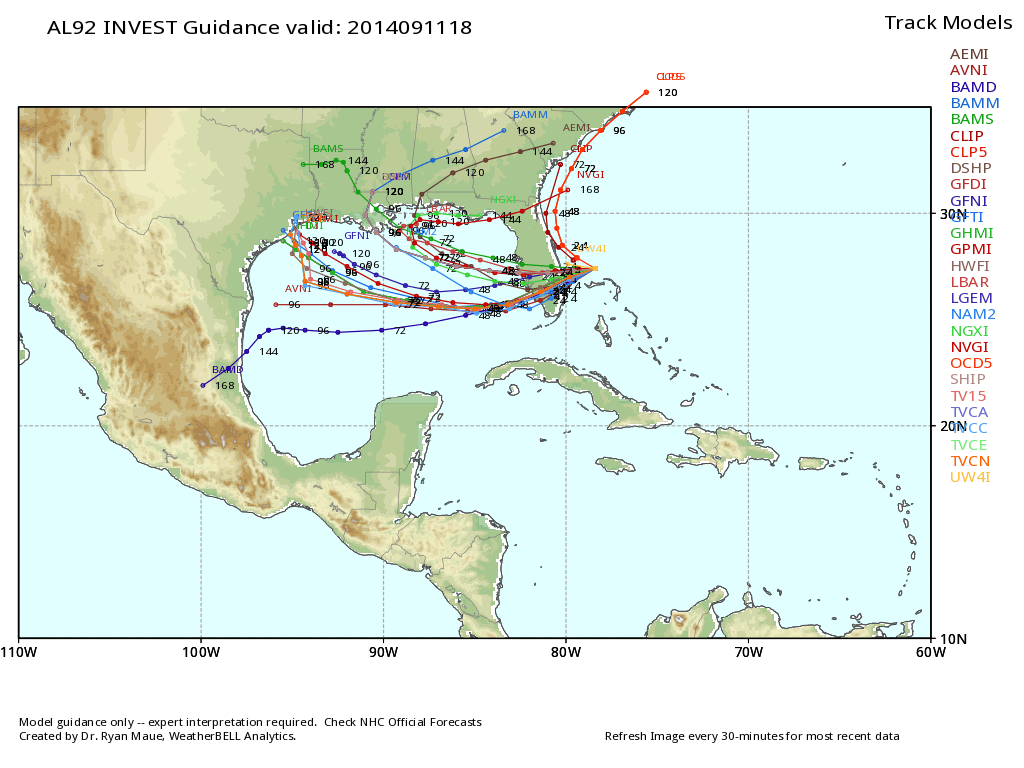
We will keep an eye on it.
GULF COAST WEATHER: About 6 to 8 hours of sunshine each day through the weekend on the coast from Panama City over to Gulf Shores with the usual risk of scattered thunderstorms. Highs on the immediate coast will be in the mid 80s, and the sea water temperatures are mostly in the mid 80s.
WEATHER BRAINS: Don’t forget you can listen to our weekly 90 minute netcast anytime on the web, or on iTunes. This is the show all about weather featuring many familiar voices, including our meteorologists here at ABC 33/40.
CONNECT: You can find me on all of the major social networks…
Facebook
Twitter
Google Plus
Instagram
Look for the next Weather Xtreme video here by 7:00 a.m. tomorrow….
Category: Alabama's Weather
About the Author (Author Profile)
James Spann is one of the most recognized and trusted television meteorologists in the industry. He holds the AMS CCM designation and television seals from the AMS and NWA. He is a past winner of the Broadcast Meteorologist of the Year from both professional organizations.Subscribe
If you enjoyed this article, subscribe to receive more just like it.


