

Active Storms Moving Across Alabama
An all new edition of the ABC 33/40 Weather Xtreme video is available in the player on the right sidebar of the blog. You can subscribe to the Weather Xtreme video on iTunes by clicking here.
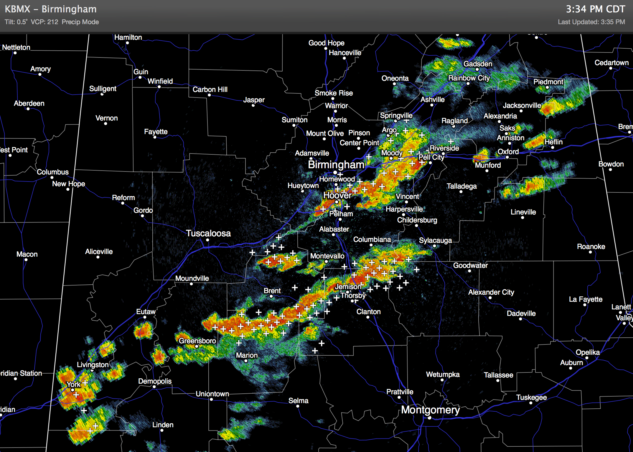
RADAR CHECK: A number of strong storms are in progress over the North/Central part of Alabama this afternoon… heavier storms are producing heavy rain and lots of lighting as they move from west to east. The storms will die down late tonight.
TOMORROW: A surface front will creep through North Alabama, so we will still mention some risk of a shower or thunderstorm, but the air tomorrow should be drier and more stable, so showers should be pretty widely spaced, and many communities won’t see any rain; the high will be in the mid 80s.
WEDNESDAY THROUGH FRIDAY: Fantastic weather Wednesday and Thursday; sunny days, fair cooler nights, and low humidity levels. Highs in the low to mid 80s; we should reach the upper 50s early Thursday morning. Some of the cooler pockets might even see low to mid 50s at daybreak Thursday. Friday should be dry for most of the state; we will keep an eye on a potential CAD setup (cold air damming) that could bring some clouds into East Alabama, but the possibility doesn’t look too high now.
FOOTBALL WEATHER: Auburn will play a Thursday night special this week in Manhattan, Kansas against Kansas State (6:30p CT kickoff); we project a temperature of 77 degrees at kickoff with only a small risk (15-20 percent) of a shower during the first half. Temperatures will fall into the low 70s by the fourth quarter.
THE ALABAMA WEEKEND: Looks very nice; dry air will stay in place meaning sunny warm days and fair pleasant highs. Highs will be in the low to mid 80s, with lows in the low to mid 60s. No chance of rain.
NEXT WEEK: A weak cold front might trigger a few showers Monday, but for now it doesn’t look like a big rain event. See the Weather Xtreme video for maps, graphics, and more details.

TROPICAL WEATHER: Hurricane Edouard, in the middle of the Atlantic Ocean, is packing sustained winds of 105 mph, and will remain far from land as it recurves. Hurricane Odile is moving northward over the Baja California peninsula of Mexico, and will be downgraded to a tropical storm tonight as it continues to weaken. Moisture from Odile could bring flash flooding to parts of Arizona and New Mexico later this week.
GULF COAST WEATHER: About 4 to 6 hours of sunshine tomorrow from Panama City west to Gulf Shores with scattered thunderstorms; then mostly sunny days, fair nights through the weekend with only very isolated showers. Highs will be in the mid to upper 80s, and sea water temperatures remain mostly in the mid 80s.
WEATHER BRAINS: Don’t forget you can listen to our weekly 90 minute netcast anytime on the web, or on iTunes. This is the show all about weather featuring many familiar voices, including our meteorologists here at ABC 33/40. We will produce this week’s show tonight at 8:30 CT… you can watch it on “James Spann 24/7” on cable systems around the state, or on the web here.
CONNECT: You can find me on all of the major social networks…
Facebook
Twitter
Google Plus
Instagram
Look for the next Weather Xtreme video here by 7:00 a.m. tomorrow….
Category: Alabama's Weather
About the Author (Author Profile)
James Spann is one of the most recognized and trusted television meteorologists in the industry. He holds the AMS CCM designation and television seals from the AMS and NWA. He is a past winner of the Broadcast Meteorologist of the Year from both professional organizations.Subscribe
If you enjoyed this article, subscribe to receive more just like it.


