Dry Days Ahead; Cooler Nights
An all new edition of the ABC 33/40 Weather Xtreme video is available in the player on the right sidebar of the blog. You can subscribe to the Weather Xtreme video on iTunes by clicking here.
RADAR CHECK: Most of the showers and storms in Alabama this afternoon are down over the southern half of the state… but within the last few minutes a few storms have fired up along a surface boundary over North Alabama. We will maintain the chance of an isolated shower or storm this evening, but the sky becomes clear late tonight as dry air takes over.We drop down into the mid 60s early tomorrow morning.
REST OF THE WEEK: Looks very nice, with ample sunshine tomorrow, Thursday, and Friday. Highs will be generally in the mid 80s; the coolest morning will come early Thursday with temperatures generally between 58 and 62 degrees. Low clouds and cold air damming over Georgia could try and creep into extreme East Alabama Friday, but for now it looks like the main impact will be east of Alabama.
THURSDAY NIGHT FOOTBALL: Auburn is off to Manhattan, Kansas, for a Thursday night showdown with the Kansas State Wildcats. Kickoff is at 6:30 CDT. The weather forecast for the game has only a slight chance of a passing shower, but it looks as though by game time it should only be partly cloudy with temps at or just below 80. By the end of the game, expect temps to be in the lower 70s. It should be breezy with winds ranging 10-15 mph out of the southeast.
THE ALABAMA WEEKEND: Saturday will be another dry day with a sunny sky and a high in the mid 80s. The latest GFS run keeps most of Alabama dry Sunday, although a cold front will be approaching by Sunday night. We will just mention the risk of a few widely scattered showers Sunday night or Monday morning with the front; at the moment it doesn’t look like a major rain producer. However, should some of the moisture from Tropical Storm Odile wrap ahead of the front, that could change. We will keep an eye on the situation.
The first few days of next week look dry and pleasant; see the Weather Xtreme video for maps, graphics, and more details.
TROPICS: Hurricane Edouard achieved “major hurricane” status this morning as winds have reached 115 mph, making it a category three storm on the Saffir Simpson scale. It is in the middle of the Atlantic, and will recurve harmlessly over open water and is no threat to land.
Tropical Storm Odile will dissipate over the northern Gulf of California over the next 48 hours, but moisture will move up into Arizona and New Mexico, bringing a flash flood threat to the Southwest U.S.
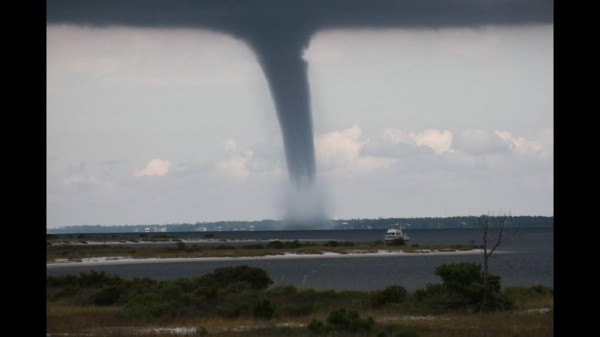
GULF COAST WEATHER: Some very active weather today with this waterspout during the late morning hours near Navarre Beach (photo from Jack Burton)…
Drier air reaches the coast tomorrow, and the weather will feature mostly sunny days and fair nights through the weekend from Panama City over to Gulf Shores with only isolated showers. Highs will be in the mid to upper 80s, and sea water temperatures remain in the mid 80s.
WEATHER BRAINS: Don’t forget you can listen to our weekly 90 minute netcast anytime on the web, or on iTunes. This is the show all about weather featuring many familiar voices, including our meteorologists here at ABC 33/40.
CONNECT: You can find me on all of the major social networks…
Facebook
Twitter
Google Plus
Instagram
I enjoyed seeing everyone today at the Harvest of Hope banquet to benefit Oak Mountain Missions… look for the next Weather Xtreme video here by 7:00 a.m. tomorrow…
Category: Alabama's Weather


