

A Beautiful Late Summer Day; Slight Taste of Fall Ahead
A gorgeous late summer day is in progress across the state.
Fluffy cumulus clouds populate the sky, with better development over the Tennessee Valley and North Central part of the state.
Temperatures were in the middle and upper 80s.
Showers and thunderstorms were starting to fill in along our cold front, which has passed Memphis and is knocking on the door of the Northwest Corner of Alabama.
Those showers and storms should fill in a bit more as the front pushes southeastward, despite rather limited moisture. This will give a chance for showers and storms later tonight as the front progresses.
They will begin to die again after midnight as they push south of I-20. Here is the 4 km NAM Simulated radar reflectivity, a look at what the radar might look like around midnight:
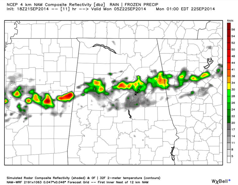
So there is a chance of showers and storms across North and North Central Alabama through the evening tonight, diminishing after midnight.
By sunrise, showers and storms should be well south of I-20, with decreasing clouds to the north. The showers and storms should be south of Clanton by late morning and pushing south of Montgomery by early afternoon.
Highs tomorrow will remain in the 70s in areas north of US-78, with lower 80s to the south.
50s will be the rule Tuesday morning with 40s in the normally colder locations.
Category: Alabama's Weather
About the Author (Author Profile)
Bill Murray is the President of The Weather Factory. He is the site's official weather historian and a weekend forecaster. He also anchors the site's severe weather coverage. Bill Murray is the proud holder of National Weather Association Digital Seal #0001 @wxhistorianSubscribe
If you enjoyed this article, subscribe to receive more just like it.


