

Severe Weather Threat Ahead For Alabama
An all new edition of the ABC 33/40 Weather Xtreme video is available in the player on the right sidebar of the blog. You can subscribe to the Weather Xtreme video on iTunes by clicking here.
As always before any severe weather threat, I encourage you to watch the Weather Xtreme video for the maps, graphics, and detailed information on what is ahead.
AT DAYBREAK: Things are pretty quiet early this morning; just a few sprinkles on the radar near the Tennessee border… most of the state is rain-free with temperatures in the upper 60s and low 70s around here. We don’t expect any weather problems through the morning hours.
SEVERE STORMS AHEAD: A vigorous upper trough west of Alabama, with an attendant surface low and cold front, will bring the threat of severe weather to our state late today and tonight. Here is a look at what we expect across Alabama…
TIMING: Severe storms could develop over the western half of Alabama as early as 4:00-5:00 this afternoon. These thunderstorms will be capable of producing hail, damaging wind, and maybe even a tornado or two. The primary squall line will enter West Alabama late tonight, around midnight, and will move slowly through the state during the pre-dawn hours. After midnight, the core threat shifts to damaging straight line wind along the squall line. It could very well be after daybreak tomorrow before the storms impact places like Anniston and Gadsden in East Alabama.
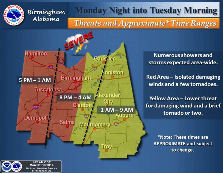
THREATS: The highest tornado probabilities are west of Alabama, around Memphis and the Mississippi Delta this afternoon and early tonight, but clearly there will be a risk of a few tornadoes over West Alabama between 5:00 p.m. and 10:00 p.m. All of Alabama will have a risk of damaging straight line winds, with individual thunderstorms, and with the organized line that will move through after midnight. And, some hail is also possible in stronger storms.
FLASH FLOODING: A flash flood watch is in effect for that part of Alabama north of a line from Millport to Jasper to Oneonta to Fort Payne. Keep in mind this part of the state, received significant rain over the weekend; we have reports of almost five inches of rain around Cullman. Additional rain amounts of 1 to 2 inches will create the risk of flooding tonight.
GET THE WARNINGS! Remember, if you think you will hear an outdoor warning siren late tonight while you family is sleeping, you pretty much have no hope of getting a warning. Every home needs a properly programmed NOAA Weather Radio, and a good “second layer” is a smart phone app like MyWarn, or WeatherRadio. Be sure you and your family can hear severe weather warnings late this afternoon and tonight.
ABC 33/40 COVERAGE: If any part of our TV market is under a tornado warning, you know the deal… we go on the air, and stay on the air. When we have no active tornado warnings, tonight we will be on our live stream, and our digital weather channel “James Spann 24/7” on cable systems around the state. You can access the live stream through any ABC 33/40 app, including the James Spann 24/7 app, or on the ABC 33/40 web site.
REST OF THE WEEK: Rain moves out of the state tomorrow, and the weather turns much cooler with a gusty north breeze. A cut-off upper low will persist north of the state Wednesday, and could keep clouds over the northern third of the state, and maybe even a touch of light rain or drizzle around the Tennessee Valley. A good chance we won’t get out of the 60s Wednesday.
Then, the weather will be delightful Thursday and Friday with sunny pleasant days and clear cool nights; highs in the 70s and lows down around 50 degrees. Colder pockets will visit the 40s.
THE ALABAMA WEEKEND: Could not be better. Clear weather continues; highs in the 70s, lows in the 50s. Perfect for race weekend at Talladega, football, or anything else you want to do outdoors.
TROPICS: We have a pair of tropical storms in the Atlantic; Fay is east of Bermuda, and is moving east over the open Atlantic. And, Gonzalo is near the Leeward Islands; it will be near the eastern tip of Puerto Rico after midnight tonight as a strong tropical storm, and should become a hurricane tomorrow as moves over the open Atlantic. These will not impact the U.S. mainland.
WEATHER BRAINS: Don’t forget you can listen to our weekly 90 minute netcast anytime on the web, or on iTunes. This is the show all about weather featuring many familiar voices, including our meteorologists here at ABC 33/40. We have moved this week’s show to tomorrow night at 8:30p CT due to the severe weather threat tonight.
CONNECT: You can find me on all of the major social networks…
Facebook
Twitter
Google Plus
Instagram
I will be doing a weather program today at Oliver Elementary School in Birmingham… we will have frequent updates on the severe weather threat here on the blog through the day, and of course as the event unfolds tonight and tomorrow morning. I will post another detailed discussion by 4:00 this afternoon. Enjoy the day!
Category: Alabama's Weather
About the Author (Author Profile)
James Spann is one of the most recognized and trusted television meteorologists in the industry. He holds the AMS CCM designation and television seals from the AMS and NWA. He is a past winner of the Broadcast Meteorologist of the Year from both professional organizations.Subscribe
If you enjoyed this article, subscribe to receive more just like it.


