

Warm Today; Cooler Air By Mid-Week
An all new edition of the ABC 33/40 Weather Xtreme video is available in the player on the right sidebar of the blog. You can subscribe to the Weather Xtreme video on iTunes by clicking here.
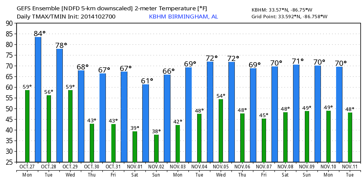
CHECKING THE RECORD BOOKS: Birmingham’s record high for today (October 27) is 88 degrees, set in 1940. I don’t think we get that warm, but low to mid 80s are likely this afternoon as the unseasonably warm weather continues across the great state of Alabama. Today’s average high is 71. The air is dry, and the sky will remain mostly sunny as an upper ridge is overhead.
We also should mention today is the 12 consecutive day without rain for the state.
TOMORROW/WEDNESDAY: We stay dry tomorrow with a partly sunny sky; the high will drop back into the upper 70s. Then, a cold front will bring the risk of showers late tomorrow night and during the day Wednesday. The main window for showers for North-Central Alabama will come from about 10:00 p.m. tomorrow through 1:00 p.m. Wednesday. This will not be a big rain event due to limited moisture; amounts will be generally under 1/2 inch, and many places will see totals under 1/4 inch. A little thunder is possible, but it will be mostly rain showers.
Wednesday will be much cooler with a high only around 70 degrees.
THURSDAY/FRIDAY: These two days will be cool and dry; great weather for high school football and trick or treating. The high both days will be in the 67-70 degree range, with morning lows in the 40s.
OUR WEEKEND: Cool, dry weather continues as we begin the month of November. Expect a sun filled sky Saturday and Sunday with highs in the 60s, and lows well down in the 40s. Colder pockets should visit the 30s both mornings.
We stay dry early next week; the GFS hints at a decent rain event around Wednesday November 5. See the Weather Xtreme video for maps, graphics, and more details.
TROPICS: All is quiet across the Atlantic basin, and tropical storm formation is not expected this week.
GULF COAST WEATHER: Mostly sunny days, fair nights on the coast from Panama City west to Gulf Shores through the weekend; the one exception is Wednesday when there will be a few cloudy periods with a risk of scattered showers. Highs will be mostly in the 70s, with lows in the 60s. Cooler nights are likely by the end of the week and the weekend with lows down in the 50s by then.
WEATHER BRAINS: Don’t forget you can listen to our weekly 90 minute netcast anytime on the web, or on iTunes. This is the show all about weather featuring many familiar voices, including our meteorologists here at ABC 33/40. We will produce this week’s show tonight at 8:30 CT… you can watch it on “James Spann 24/7” on cable systems around the state, or on the web here.
CONNECT: You can find me on all of the major social networks…
Facebook
Twitter
Google Plus
Instagram
I will be doing a weather program this morning at Walker Elementary School in Tuscaloosa County… look for the next Weather Xtreme video here by 4:00 this afternoon. Enjoy the day!
Category: Alabama's Weather
About the Author (Author Profile)
James Spann is one of the most recognized and trusted television meteorologists in the industry. He holds the AMS CCM designation and television seals from the AMS and NWA. He is a past winner of the Broadcast Meteorologist of the Year from both professional organizations.Subscribe
If you enjoyed this article, subscribe to receive more just like it.


