

Cold Front On The Way
An all new edition of the ABC 33/40 Weather Xtreme video is available in the player on the right sidebar of the blog. You can subscribe to the Weather Xtreme video on iTunes by clicking here.
NOT AS WARM TODAY: Anniston established a new record high yesterday for October 27 with 87 degrees… Birmingham’s high was 86, and Tuscaloosa reached 85. The average high is 71.
Today won’t be as warm; most places will see a high in the upper 70s with a partly sunny sky. And, we should mention today is the 13th consecutive day with no rain for Alabama.
SHOWERS ARRIVE LATE TONIGHT: A band of showers and thunderstorms ahead of a cold front should move into the northwest corner of the state late tonight; it will then move slowly southward. For places like Birmingham, Tuscaloosa, Anniston, and Gadsden, the main window for rain will come from about 3:00 a.m. until 12:00 noon tomorrow.
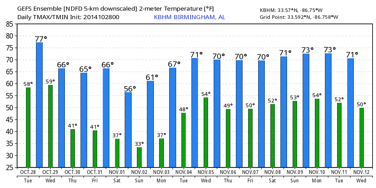
For most communities, rain amounts will be under 1/2 inch with limited moisture. And, while some thunder is possible, there is no risk of severe weather. The sky will clear tomorrow afternoon, and the day will be noticeably cooler with a high in the 60s.
THURSDAY/FRIDAY: These two days will be cool and dry with a good supply of sunshine; the high Thursday will be in the upper 60s, followed by low 70s Friday. Lows will be generally in the 40-45 degree range, although some of the colder valleys could see upper 30s.
WEEKEND CHILL: The coldest air so far this season blows in here; we won’t get out of the 50s Saturday, and by early Sunday we project lows in the 33-38 degree range for most communities with a good chance of frost. Colder spots will see a freeze. The air over the weekend will be dry, and the sky will be sunny both days.
FOOTBALL WEATHER: For Friday night’s high school games, it will be clear and very cool with temperatures falling through the 50s, possibly reaching the 40s by the final whistle.
Auburn will be on the road; they play at Ole Miss in Oxford Saturday evening (kickoff 6p CT). The sky will be clear, temperatures will fall from 55 degrees at kickoff into the mid 40s by the fourth quarter. Perfect cool, crisp night for football.
UAB is also on the road; they play at Florida Atlantic in Boca Raton, FL Saturday evening (5p CT kickoff). Again, a clear sky is likely with temperatures falling from near 80 at kickoff to the mid 70s by the fourth quarter.
NEXT WEEK: Looks like we have potential for a decent rain event around Wednesday November 5… see the Weather Xtreme video for the maps, graphics, and more details.
TROPICS: Tropical Storm Hanna moved into Central America last night and is dissipating; the rest of the Atlantic basin is quiet for now.
GULF COAST WEATHER: A few scattered showers are possible tomorrow afternoon from Panama City over to Gulf Shores, otherwise dry weather continues through the weekend with sunny days and fair nights. The weekend will be very cool on the coast, with highs in the 60s and lows in the 40s Saturday and Sunday.
WEATHER BRAINS: Don’t forget you can listen to our weekly 90 minute netcast anytime on the web, or on iTunes. This is the show all about weather featuring many familiar voices, including our meteorologists here at ABC 33/40. Scroll down for the show notes on the new episode we recorded last night.
CONNECT: You can find me on all of the major social networks…
Facebook
Twitter
Google Plus
Instagram
I have a weather program today at Hayden Elementary School in Blount County… be looking for the next Weather Xtreme video here by 4:00 this afternoon. Enjoy the day!
Category: Alabama's Weather
About the Author (Author Profile)
James Spann is one of the most recognized and trusted television meteorologists in the industry. He holds the AMS CCM designation and television seals from the AMS and NWA. He is a past winner of the Broadcast Meteorologist of the Year from both professional organizations.Subscribe
If you enjoyed this article, subscribe to receive more just like it.


