

Big Change To Cold Weather Ahead
An all new edition of the ABC 33/40 Weather Xtreme video is available in the player on the right sidebar of the blog. You can subscribe to the Weather Xtreme video on iTunes by clicking here.
LAST MILD DAY FOR A WHILE: Temperatures are up in the low 70s across the great state of Alabama this afternoon; Tuscaloosa is up to 75 at 3:00. But, the long discussed Arctic front is very close. Memphis is down to 49 degrees at mid-afternoon, and the leading edge of that cold air will be entering Northwest Alabama soon.
TONIGHT: A little scattered light rain is likely along the front tonight, but amounts should be generally under 0.05″, and many places won’t get enough to measure.

BIG TIME COLD FOR NOVEMBER: We will struggle to reach the low 50s tomorrow; the sky will be cloudy the morning, but a few intervals of afternoon sunshine are possible.
Then, for Thursday and Friday, we project highs only in the 40s, with lows down in the 20s. The air will be dry, and the sky will be partly to mostly sunny both days.
THE ALABAMA WEEKEND: Saturday morning will be another very cold one with lows down in the mid 20s. During the day, we project a high in the low 50s with a mix of sun and clouds. Clouds increase Saturday night, and Sunday still looks like cold and wet day with periods of rain and a high only in the mid 40s. Average rain amounts of 1/2 inch are likely, but some places south of Birmingham could see up to one inch.
As the rain begins early Sunday, there is a chance we see a little sleet in the mix, but that shouldn’t last long as the day should feature mostly rain.
WINTER WEATHER MISCHIEF SUNDAY NIGHT AND MONDAY MORNING? The GFS continues to advertise a surface low south of Mobile Bay Sunday, then moving to a point off the mid-Atlantic coast Monday. This will pull another surge of cold, Arctic air into Alabama, and there is some chance the rain could change to light snow before ending over about the northern third of Alabama.
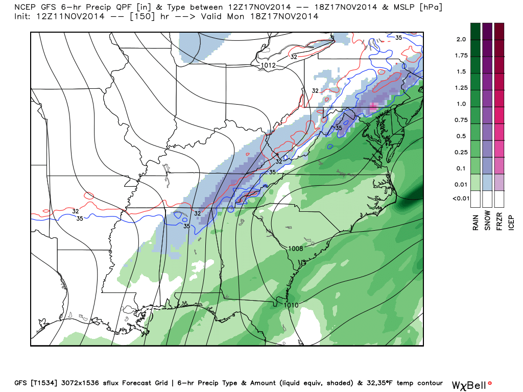
The better chance of seeing any signifiant accumulation for now is up around the Tennessee border, and even there amounts probably won’t be that high. But, understand this is five days out, and things will change as we get closer.
No need to buy mild and bread, or YooHoos and Twinkies. No need to stock up for a blizzard, and no need to run down the street screaming “it is going to snow”. This is just to let you know of the potential, and we will be able to be much more specific later this week.
NEXT WEEK: After the precipitation ends Monday morning, more cold air arrives. Parts of North Alabama might have a hard time getting out of the 30s Tuesday; most places around here will see highs in the 40s and lows in the 20s early in the week before a slow warming trend begins.
Take some time to see the Weather Xtreme video for the maps, graphics, and more details.
FOOTBALL WEATHER: For the high school playoff games Friday night, we project a kickoff temperature around 40 degrees, then falling through the 30s during the games. Needless to say, you will need to bundle up. The sky will be clear.
The biggest college game in the country will be in Tuscaloosa Saturday as Mississippi State comes to town to take on Alabama. If you are planning on being with the ESPN GameDay crew, early morning temperatures will be in the upper 20s, rising through the 30s, and reaching the 40s by late morning. The kickoff temperature (2:30p CT) will be close to 52 degrees with a partly sunny sky, but as the sun goes down temperatures will drop quickly into the 40s during the second half.
Auburn will be over in Athens, GA to take on the Georgia Bulldogs Saturday evening (6:15p CT kickoff)… expect a party cloudy sky with a temperature near 46 degrees at kickoff, then dropping slowly through the 40s during the game.
LOOK BACK AT SNOWJAM 2014: The January 28th Winter Storm earlier this year will be legendary for decades across Central Alabama. Keith Stellman, the Meteorologist in Charge at the National Weather Service Atlanta will talk about the event’s impact and meteorology at the Central Alabama National Weather Association Meeting this coming Monday, November 17th. The meeting starts at 7 p.m. in room F at the Medical Forum Building in the BJCC Downtown. The meeting is free to NWA Chapter members, visitors are $10 For more information, see Bill’s blog post below.
WEATHER BRAINS: Don’t forget you can listen to our weekly 90 minute netcast anytime on the web, or on iTunes. This is the show all about weather featuring many familiar voices, including our meteorologists here at ABC 33/40.
CONNECT: You can find me on all of the major social networks…
Facebook
Twitter
Google Plus
Instagram
Look for the next Weather Xtreme video here by 7:00 a.m. tomorrow…
Category: Alabama's Weather
About the Author (Author Profile)
James Spann is one of the most recognized and trusted television meteorologists in the industry. He holds the AMS CCM designation and television seals from the AMS and NWA. He is a past winner of the Broadcast Meteorologist of the Year from both professional organizations.Subscribe
If you enjoyed this article, subscribe to receive more just like it.


