

Cold Air Beginning To Arrive In Alabama
An all new edition of the ABC 33/40 Weather Xtreme video is available in the player on the right sidebar of the blog. You can subscribe to the Weather Xtreme video on iTunes by clicking here.
SO LONG MILD WEATHER: The long advertised Arctic cold front moved through North Alabama last night, and temperatures today will be about 20 degrees colder than those of yesterday. Communities north of Birmingham won’t get out of the 40s, and for the I-20 corridor we project a high only in the low 50s. The sky will be generally cloudy with only a limited amount of sunshine.
The weather tomorrow and Friday will be even colder; highs drop into the 40s, and by early Friday morning we project temperatures in the mid 20s. The last time the high was under 50 degrees in Birmingham was back on March 6, when the high was 49. These two days will be dry; expect a mix of sun and clouds Thursday, and sunshine in full supply Friday.

THE ALABAMA WEEKEND: The weather Saturday will be cold and dry… with a partly sunny sky we project a high in the low 50s after a frigid start with mid 20s around daybreak. Then, Sunday will be cold and wet with rain much of the day along with temperatures only in the 40s.
As the rain begins early Sunday morning, I would not be surprised to hear of some sleet reports over North Alabama… this happens when precipitation begins falling through drier layers of the atmosphere, and evaporative cooling takes place. That won’t create any problems if it happens… just plan on a cold, wet day Sunday. Rain amounts around 1/2 inch look likely, with potential for one inch over the southern half of the state as a surface low forms near Mobile Bay.
NORTH ALABAMA SNOW FLAKES MONDAY? As the surface low moves northeast, and colder air is pulled back into the state, there is a window with some potential for a brief changeover to light snow over parts of North Alabama Monday morning. The new high resolution GFS model (still in beta, running parallel to the current operational GFS) hints at this…
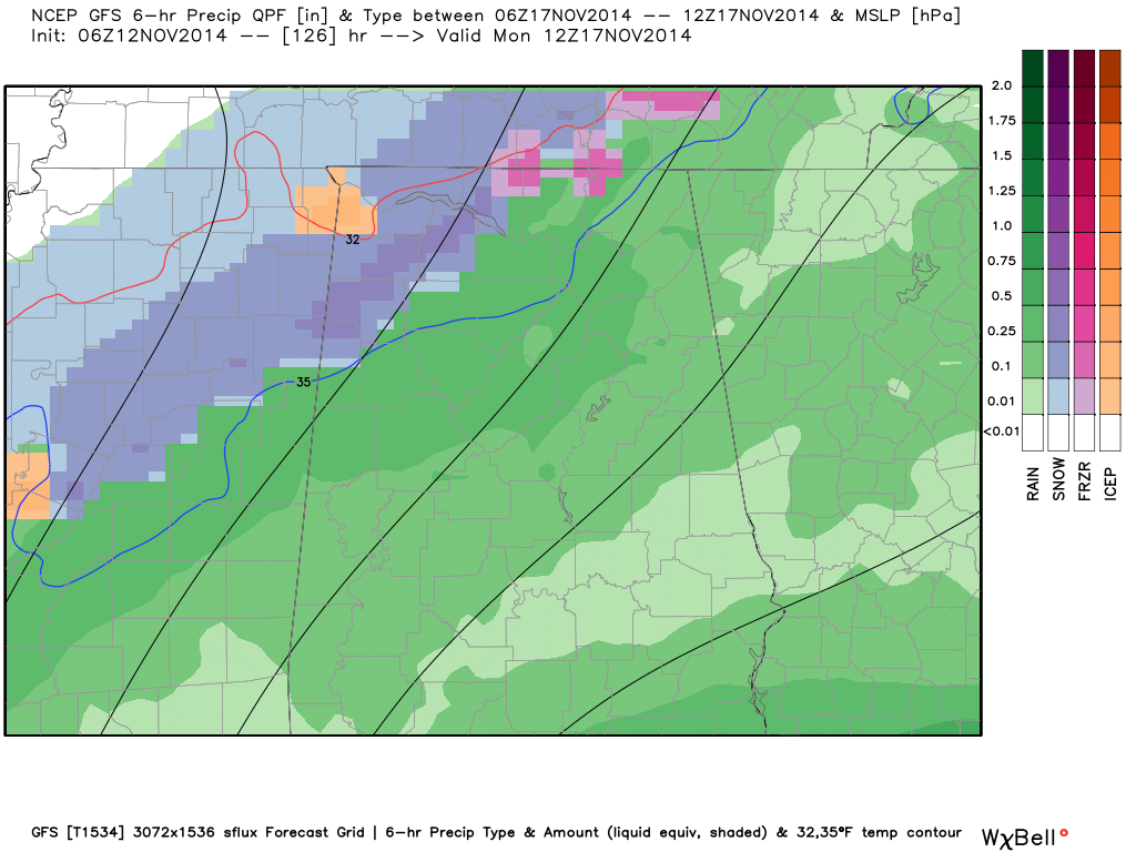
But, the European model takes the surface low on a more northerly track and keeps the wintry precipitation over Tennessee. Needless to say, at this stage of the game, there is great uncertainty, but we will just throw out the idea for now and keep an eye on model trends in coming days. One way or another I would say it probably won’t be a high impact event. See the Weather Xtreme video for the maps, graphics, and more details.
FOOTBALL WEATHER: For the high school playoff games Friday night, we project a kickoff temperature around 40 degrees, then falling through the 30s during the games. Needless to say, you will need to bundle up. The sky will be clear.
The biggest college game in the country will be in Tuscaloosa Saturday as Mississippi State comes to town to take on Alabama. If you are planning on being with the ESPN GameDay crew, early morning temperatures will be in the upper 20s, rising through the 30s, and reaching the 40s by late morning. The kickoff temperature (2:30p CT) will be close to 52 degrees with a partly sunny sky, but as the sun goes down temperatures will drop quickly into the 40s during the second half.
Auburn will be over in Athens, GA to take on the Georgia Bulldogs Saturday evening (6:15p CT kickoff)… expect a party cloudy sky with a temperature near 46 degrees at kickoff, then dropping slowly through the 40s during the game.
LONG RANGE: The Arctic Oscillation (AO) and the North Atlantic Oscillation (NAO) are trending toward positive territory late in the month, which would suggest a trend toward warmer temperatures as we approach Thanksgiving, not we don’t see anything to suggest any really mild weather for the next 15 days.
WEATHER BRAINS: Don’t forget you can listen to our weekly 90 minute netcast anytime on the web, or on iTunes. This is the show all about weather featuring many familiar voices, including our meteorologists here at ABC 33/40.
CONNECT: You can find me on all of the major social networks…
Facebook
Twitter
Google Plus
Instagram
I have a weather program today at Walnut Park Elementary School in Gadsden… be looking for the next Weather Xtreme video here by 4:00 this afternoon. Enjoy the day!
Category: Alabama's Weather
About the Author (Author Profile)
James Spann is one of the most recognized and trusted television meteorologists in the industry. He holds the AMS CCM designation and television seals from the AMS and NWA. He is a past winner of the Broadcast Meteorologist of the Year from both professional organizations.Subscribe
If you enjoyed this article, subscribe to receive more just like it.


