

Twenty Degrees Below Average
An all new edition of the ABC 33/40 Weather Xtreme video is available in the player on the right sidebar of the blog. You can subscribe to the Weather Xtreme video on iTunes by clicking here.
CLOUDS HANGING TOUGH: Like yesterday, I don’t expect that we will see much sunshine today across Alabama as cold air continues to move into the state. Temperatures are in the 30-35 degree range at daybreak, and we will struggle to reach the low to mid 40s this afternoon with an icy north breeze.
To the south, rain will fall over far South Alabama at times today, with the best chance south of U.S. 84. And, it is interesting to note that snow flakes have been falling early this morning around Memphis and Little Rock; the Memphis NWS office reports 0.1″ of snow there, the earliest measurable snow on record for them.
The wave producing the light snow over the Mid-South could bring a few sprinkles or flurries to far North Alabama this morning, but temperatures will be above freezing and it won’t be anything significant.
TONIGHT/TOMORROW: The sky becomes clear tonight, and this will allow temperatures will fall into the mid 20s by daybreak tomorrow. Last time we saw mid 20s was back on March 26, when Birmingham’s low was 25 degrees. The NWS offices in Birmingham and Mobile have issued freeze warnings for their county warning areas; freezing temperatures are likely down to the Gulf Coast. NWS Huntsville won’t be issuing any more freeze warnings since they have already had a significant freeze.
Tomorrow will be a brighter day with a good supply of sunshine, but the weather stays cold with a high only in the mid 40s.
THE ALABAMA WEEKEND: Expect another low down in the mid 20s early Saturday; the day will be mostly sunny with a high at or just over 50 degrees. Clouds thicken late Saturday night ahead of a wave that will bring rain to the state as the weekend wraps up.
Rain will move into North Alabama at some point Sunday afternoon, becoming widespread Sunday night. With a later start time of the rain, that means a good chance the high will be in the 50s Sunday afternoon (earlier we forecast temperatures in the 40s all day when it looked like the rain could start earlier in the day). This will be a good rain event, with amounts of 1/2 to 1 inch for North/Central Alabama. South Alabama could see over one inch in spots.

MONDAY: The rain ends during the day Monday as a surface low moves away to the northeast. Some outside risk of a few snow flakes on the back side of the precipitation mass over far North Alabama, but model trends suggest this won’t amount to anything, and I have removed the mention from our formal forecast for now.
FOOTBALL WEATHER: For the high school playoff games tomorrow night, we project a kickoff temperature around 40 degrees, then falling through the 30s during the games. Needless to say, you will need to bundle up. The sky will be clear.
The biggest college game in the country will be in Tuscaloosa Saturday as Mississippi State comes to town to take on Alabama. If you are planning on being with the ESPN GameDay crew, early morning temperatures will be in the mid 20s around daybreak, rising through the 30s, and reaching the 40s by late morning. The kickoff temperature (2:30p CT) will be close to 51 degrees with a mostly sunny sky, but as the sun goes down temperatures will drop quickly into the 40s during the second half.
Auburn will be over in Athens, GA to take on the Georgia Bulldogs Saturday evening (6:15p CT kickoff)… expect 46 degrees at kickoff, with temperatures dropping slowly through the 40s during the game. The sky should be mostly fair.
MORE COLD AIR NEXT WEEK: The air coming in here Tuesday (November 18) looks very cold; new data hints that the far northern part of Alabama could stay below freezing all day; with a high only in the mid to upper 30s for places like Birmingham, Tuscaloosa, Anniston, and Gadsden…
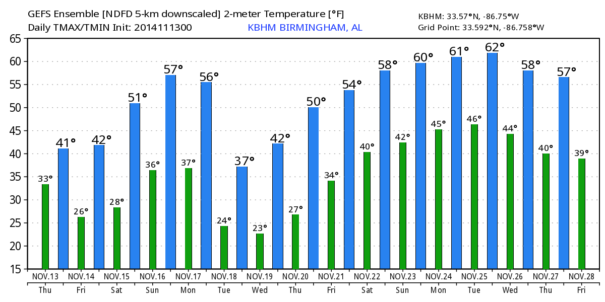
Coldest morning will come early Wednesday with low 20s likely, with teens for the colder places. Then, a slow warming trend begins Wednesday afternoon. See the Weather Xtreme video for the maps, graphics, and details.
WEATHER BRAINS: Don’t forget you can listen to our weekly 90 minute netcast anytime on the web, or on iTunes. This is the show all about weather featuring many familiar voices, including our meteorologists here at ABC 33/40.
CONNECT: You can find me on all of the major social networks…
Facebook
Twitter
Google Plus
Instagram
Look for the next Weather Xtreme video here by 4:00 this afternoon… enjoy the day…
Category: Alabama's Weather
About the Author (Author Profile)
James Spann is one of the most recognized and trusted television meteorologists in the industry. He holds the AMS CCM designation and television seals from the AMS and NWA. He is a past winner of the Broadcast Meteorologist of the Year from both professional organizations.Subscribe
If you enjoyed this article, subscribe to receive more just like it.


