

Really Cold Air On The Way
Rain overspread Northwest Alabama early this morning as advertised, in advance of a very powerful upper trough that is bringing some amazingly cold air to the center of the country and aided by a frontal system that lies generally along and north of I-20. Low pressure centers are lined up back along the front which extends across southern Mississippi.
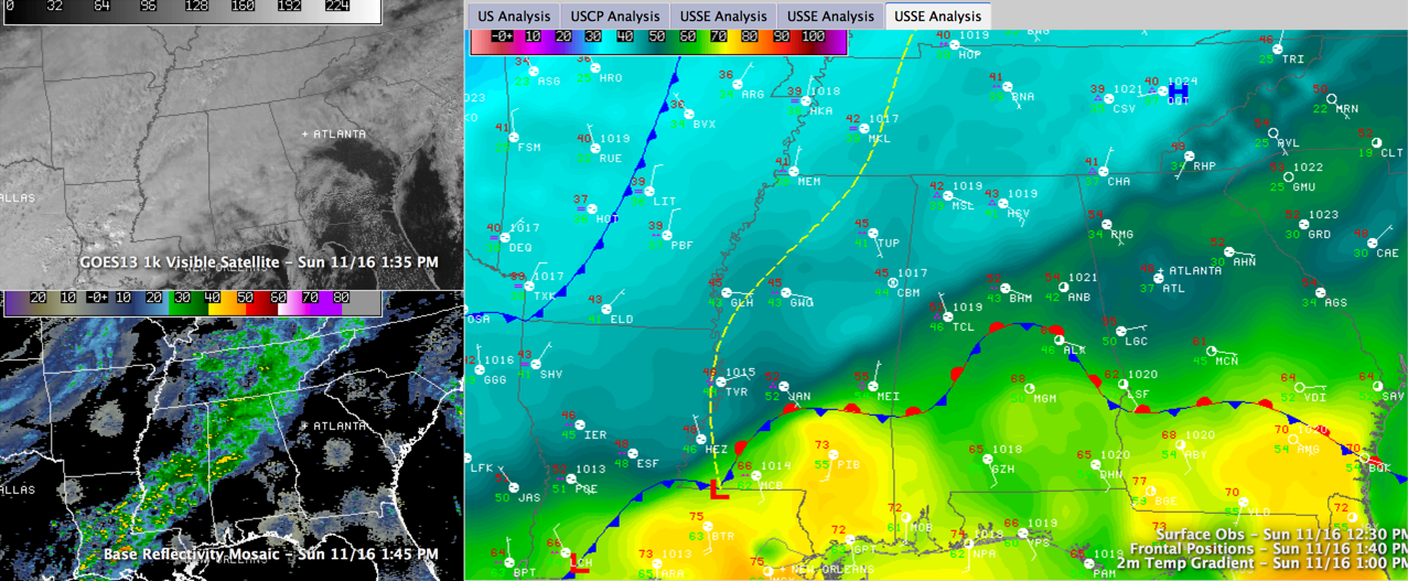
UPSTREAM TEMPS: It is interesting to note at early afternoon, temperatures are in the teens and 20s across Kansas, 30s over Arkansas and in the 40s over northern Mississippi. It was 18F at noon at Chanute, KS with heavy snow and 23F at Joplin MO with heavy snow as well. It was 39F at Little Rock and 43F at Greenwood MS. In sharp contrast, it is 70F at Mobile.
NOWCAST: As of the noon hour, rain had overspread much of the space north of I-59 and was steadily advancing eastward. This first wave of rain will continue to do so through the afternoon hours leading to a gentle, soaking rain for most locations. North of the front, temperatures are in the 40s in places like Hamilton, Muscle Shoals and Huntsville. There will likely be some evaporative cooling as rain begins to fall in areas that are in the 50s, setting the stage for a cold rain. Over three quarters of an inch of rain has fallen at Muscle Shoals this morning and much of the area should see at least one half of an inch this afternoon. Great weather for a nap.
WAVE #2: Another wave of rain will overspread the area tonight as another of those surface disturbances ripples northeastward along the front. There is currently some lightning over southwestern Mississippi and even a tornado warning west of Lafayette LA. There is a slight risk severe weather outlook in effect along the Gulf Coast from Fort Walton back to Lake Charles LA. As this low passes by, the front will start dropping southeastward pushing the rain with it. Rain should end in places like Hamilton and Carrollton by 3 a.m. or so, Birmingham and Tuscaloosa around 6 a.m. and over East Alabama soon after that. The rain should be basically out of the state by noon. Overnight rainfall amounts may be over an inch, with accumulated totals finishing around 2 inches in some spots.
SEVERE WEATHER? I know you zeroed in on my comment about a tornado warning. No, there is no threat of that coming to Alabama. Instabilities may well support a little thunder tonight in areas south of I-20.

ROLLER COASTER TEMPERATURES: Wasn’t it the Ohio Players that sang about the Rollercoaster of Love? The theme of this paragraph will be the Rollercoaster of Temperatures. Although the screaming message is the coming cold, there are a couple of things meteorologically that some of our friends will experience. As the second low pushes northeast tonight, temperatures may jump into the 50s and 60s as far north as I-20, in places like Tuscaloosa, Birmingham, Clanton, Talladega and Ashland as well as points south. Temperatures will fall during the morning across the area, with Monday daytime highs likely occurring before sunrise in many areas. That is always interesting. Temperatures will be in the lower 40s in the I-20 corridor during much of the day, falling back into the 30s during the late afternoon. Places to the north will remain in the 30s all day. The Arctic front will arrive Monday night, plunging temperatures into the lower 20s with a few teens by Tuesday morning.
FRIGID TUESDAY: Highs on Tuesday will likely not get above freezing in places along and north of I-20. We are talking highs around 30-32F. It will be a day for bundling up and dressing warmly.
TO WEDNESDAY AND BEYOND: Wednesday morning will likely be as cold if not a degree or two colder than Tuesday morning, with teens and lower 20s prevailing. Most areas should warm back to the upper 40s by Wednesday afternoon. Moderation will occur starting Thursday with 50s likely again and continuing on Friday – Sunday. The next rain chances will come late Thursday night into Friday as another front system starts acting up over the south. It could be followed by another round of rain on Sunday.
THANKSGIVING SNEAK PEEK: Some snow looks possible in the Ohio and Tennessee Valleys along with cold weather over the Southeast.
Category: Alabama's Weather
About the Author (Author Profile)
Bill Murray is the President of The Weather Factory. He is the site's official weather historian and a weekend forecaster. He also anchors the site's severe weather coverage. Bill Murray is the proud holder of National Weather Association Digital Seal #0001 @wxhistorianSubscribe
If you enjoyed this article, subscribe to receive more just like it.


