

Frigid Air Covers The Deep South
An all new edition of the ABC 33/40 Weather Xtreme video is available in the player on the right sidebar of the blog. You can subscribe to the Weather Xtreme video on iTunes by clicking here.
HARD FREEZE: Here are some temperatures just before sunrise this morning…
Black Creek (just northeast of Gadsden) 18
Haleyville 18
Valley Head 18
Russellville 20
Cullman 20
Birmingham 23 (wind chill index 12)
Gadsden 23
Fayette 23
Bessemer 23
Anniston 24
Tuscaloosa 25
Wind chill index values are generally in the 10-15 degree range; we have a northwest wind around 10 mph in most places. That wind kept temperatures from reaching their lowest potential, and it looks like we won’t be breaking the record low for Birmingham today (20 set in 1959).
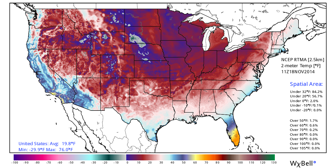
Interesting to note that 84.2 percent of the continental U.S. is below freezing at 6a CT…
Despite a sunny sky, we won’t get out of the 30s today, and tonight will feature another hard freeze with a clear sky and light wind. The radiational cooling effect will bring a wide range of temperatures early tomorrow; the coldest valleys will be close to 15, while the ridge tops will be in the mid to upper 20s.
WARMER DAYS: A warming trend begins tomorrow afternoon as we climb to near 50 degrees. Then, we reach the upper 50s Thursday, and low 60s Friday. The latter half of the week looks dry; we have removed the slight chance of a shower Friday.
THE ALABAMA WEEKEND: The daytime Saturday looks dry and pleasant with a high in the low to mid 60s, but clouds will increase late in the day, and a dynamic weather system will bring rain and storms back to the state late Saturday night into Sunday morning.
The 00Z GFS hints the main threat of showers and storms will come from about 12:00 midnight Saturday through 8:00 a.m. Sunday, thankfully at a time when the air tends to be most stable. The lack of instability will be the primary limiting factor in the severe weather threat for our part of the state; there is very little CAPE showing up on model soundings. But, we all know we can have severe weather issues with limited CAPE in the cold season.
The low level jet is forecast be in the 60 knot range, with low level bulk shear values to 30 knots, so dynamic support is very good. It could be the highest risk of severe weather will come close to the Gulf Coast during the pre-dawn hours Sunday, but this could change, and we will monitor parameters closely as we get close to the weekend. See the Weather Xtreme video for the maps, graphics, and details.
If the 00Z GFS is correct, then we could see sunshine by Sunday afternoon, with temperatures potentially rising up into the low to mid 70s as we get into a dry slot.
THANKSGIVING WEEK: A cold front is due in here Monday with a chance of showers, followed by colder air Tuesday and Wednesday. At this point we project dry weather Tuesday through Friday, with highs around 50, and lows around 30 by Thanksgiving Day. The Weather Xtreme video has a day by day walk through for Thanksgiving week and the following weekend.
WEATHER BRAINS: Don’t forget you can listen to our weekly 90 minute netcast anytime on the web, or on iTunes. This is the show all about weather featuring many familiar voices, including our meteorologists here at ABC 33/40. Scroll down for the show notes on the new episode we recorded last night.
CONNECT: You can find me on all of the major social networks…
Facebook
Twitter
Google Plus
Instagram
I will be over in Anniston today speaking to the senior adults at Parker Memorial Baptist Church… look for the next Weather Xtreme video here by 4:00 this afternoon. Enjoy the day!
Category: Alabama's Weather
About the Author (Author Profile)
James Spann is one of the most recognized and trusted television meteorologists in the industry. He holds the AMS CCM designation and television seals from the AMS and NWA. He is a past winner of the Broadcast Meteorologist of the Year from both professional organizations.Subscribe
If you enjoyed this article, subscribe to receive more just like it.


