

Slow Warm-Up Continues; Rain By Sunday
An all new edition of the ABC 33/40 Weather Xtreme video is available in the player on the right sidebar of the blog. You can subscribe to the Weather Xtreme video on iTunes by clicking here.
PRE-DAWN SHAKER: A magnitude 3.8 earthquake is the headline to start the day; it was centered in Greene County, about 30 miles southwest of Tuscaloosa, at 4:25 a.m. CT…
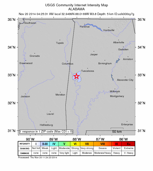
The quake was fairly shallow (3.1 miles), and while we did receive a number of reports close to the epicenter, seems like very few people felt it in Tuscaloosa (of course, most slept through it). No damage reported.
WARM-UP CONTINUES: No rain for Alabama through tomorrow; we expect a partly sunny sky with upper 50s today, and low 60s tomorrow.
SATURDAY: A 1031 mb high will be centered around Virginia Beach, and that will nose into Alabama from the east. It should set up a thermal gradient; those near the Georgia border won’t get out of the 50s Saturday afternoon, which Central and West Alabama should see a high in the 60s. Clouds will increase during the day, but the weather stays dry.
TO THE WEST: A dynamic storm system will bring the risk of severe weather to much of Southeast Texas, and into Louisiana later in the day. These storms will enter West Alabama after midnight Saturday night.
SEVERE WEATHER? Not much change in our thinking; the prime threat of severe weather with this system will be near the Gulf Coast, and perhaps up to 100 miles inland. The air will be cool and stable over the northern half of the state, and with no surface based instability, for now we don’t expect any severe weather issues for places like Birmingham, Tuscaloosa, Anniston, and Gadsden.
However, to the south, surface based CAPE values could rise to near 1,000 j/kg near the Gulf Coast, and with a strong low level jet (over 50 knots) and a decent amount of low level bulk shear (over 30 knots), a few tornadoes are not out of the question near the coast. In Alabama, the primary threat of severe storms will come from about 2:00 a.m. until 10:00 a.m. Sunday, and mostly south of a line from Grove Hill to Monroeville to Greenville to Eufaula.
Rain amounts around one inch are likely over North/Central Alabama, with totals in the 2-3 inch range near the Gulf Coast.
There is a chance the sun breaks out Sunday afternoon after the storms thanks to dry slot moving into the state, which could very well push temperatures into the low to mid 70s.
THANKSGIVING WEEK: A cold front will pass through the state Monday, and could trigger a shower or two, but it certainly doesn’t look like a big rain event, and many places will be dry. Temperatures should rise into the 60s Monday before the front comes through. Then, the rest of the week looks cool and dry. The high Tuesday will drop into the 50s, and we will have a hard time getting out of the 40s Wednesday. For Thanksgiving Day and Black Friday, we are projecting highs in the 50s, and lows in the 30s. The cool, dry weather should linger into the following weekend. For now weather for the Iron Bowl in Tuscaloosa looks rain-free. See the Weather Xtreme video for maps, graphics, and more details.
FOOTBALL WEATHER: Very nice weather for the high school football games across North/Central Alabama tomorrow night; mostly fair with temperatures falling from 53 at kickoff, into the mid to upper 40s by the final whistle.
Saturday is homecoming at the Capstone in Tuscaloosa, and for the football game (Alabama vs Western Carolina) that kicks off at 3:00 p.m.. the sky will become mostly cloudy during the game, but the weather should be dry. Expect a kickoff temperature near 62 degrees, falling to near 58 by the fourth quarter. Pretty comfortable, especially compared to last weekend.
Auburn will host the Samford Bulldogs Saturday evening at Jordan-Hare Stadium (6p CT kickoff)… mostly cloudy with 57 degrees at kickoff, and low to mid 50s by the fourth quarter. No rain expected.
WEATHER BRAINS: Don’t forget you can listen to our weekly 90 minute netcast anytime on the web, or on iTunes. This is the show all about weather featuring many familiar voices, including our meteorologists here at ABC 33/40.
CONNECT: You can find me on all of the major social networks…
Facebook
Twitter
Google Plus
Instagram
Look for the next Weather Xtreme video here by 4:00 or so this afternoon…
Category: Alabama's Weather
About the Author (Author Profile)
James Spann is one of the most recognized and trusted television meteorologists in the industry. He holds the AMS CCM designation and television seals from the AMS and NWA. He is a past winner of the Broadcast Meteorologist of the Year from both professional organizations.Subscribe
If you enjoyed this article, subscribe to receive more just like it.


