

Storms Return Before The Weekend Ends
**No afternoon Weather Xtreme video today; I am at the “Taste of Trussville” at the Trussville Civic Center, live on ABC 33/40 at 4, 5 and 6:00**
PLEASANT NOVEMBER AFTERNOON: As advertised, the warming trend is continuing. We have a few spots up in the low 60s this afternoon with sunshine through scattered clouds…
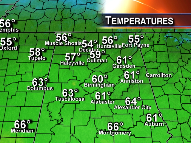
Expect a similar day tomorrow, with a mix of sun and clouds, and a high in the low 60s.
THE ALABAMA WEEKEND: The sky becomes mostly cloudy Saturday, but the day will remain dry. The eastern counties of the state won’t get out of the 50s Saturday, but low to mid 60s are possible over Central and West Alabama Saturday afternoon.
TO THE WEST: Strong to severe storms will erupt Saturday afternoon over Southeast Texas and parts of South Louisiana, and those storms will move into Alabama after midnight Saturday night. We do note the NAM model tries to bring showers up into Central Alabama as early as 9 p.m. Saturday, and we will introduce an outside risk of a shower for the fourth quarter of the Auburn/Samford football game. But, the main action comes much later.
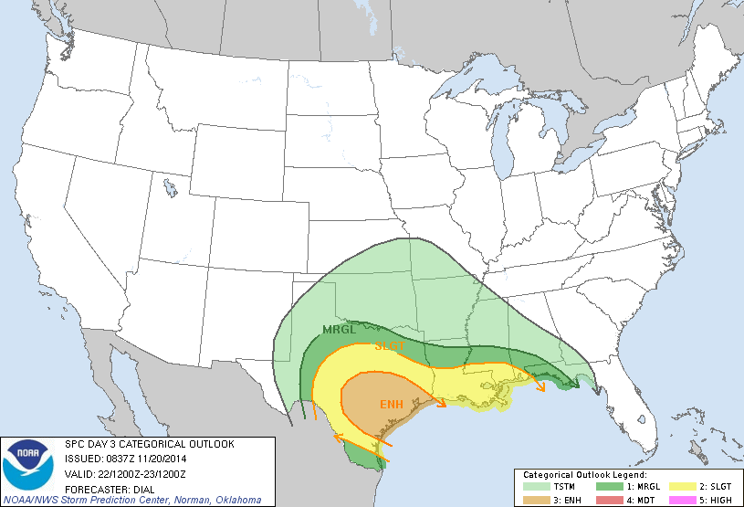
SUNDAY: Still looks like an active weather day with showers and storms likely, especially during the morning hours. Seems like the main window initially for rain and storms will come from about 2:00 a.m. until 12:00 noon Sunday; severe weather will be possible over the southern quarter of Alabama where some surfaced based instability will be available. The primary threat of severe storms will be south of a line from Grove Hill to Greenville to Eufaula. Storms down that way could produce strong winds, and an isolated tornado or two is not out of the question.
There is excellent dynamic support for thunderstorms over North Alabama with high bulk shear values (over 35 knots) and a very strong low level jet (over 60 knots), but with no surface based instability it will be hard for severe storms to get going.
A dry slot works into Alabama during the midday hours Sunday as the rain moves east, and we have potential of seeing temperatures in the 70s Sunday afternoon with some sunshine. This will actually make the air pretty unstable, and we will be watching for signs of any redevelopment late Sunday afternoon… if storms can fire up then, they could be strong statewide. Remains to be seen if that can happen, however, and most models discount that idea.
We will continue to keep a close eye on model trends in coming days as the event gets closer.
THANKSGIVING WEEK: A cold front will pass through Monday with some risk of a shower; the 12Z GFS brings in the idea of showers on Tuesday as the upper trough passes overhead, and we will insert that risk into the public forecast. Then, Wednesday through Friday next week look dry but chilly; highs drop into the 40s, with lows in the 20s by Thanksgiving Day.
WEATHER BRAINS: Don’t forget you can listen to our weekly 90 minute netcast anytime on the web, or on iTunes. This is the show all about weather featuring many familiar voices, including our meteorologists here at ABC 33/40.
CONNECT: You can find me on all of the major social networks…
Facebook
Twitter
Google Plus
Instagram
Look for the next Weather Xtreme video here by 7:00 a.m. tomorrow…
Category: Alabama's Weather
About the Author (Author Profile)
James Spann is one of the most recognized and trusted television meteorologists in the industry. He holds the AMS CCM designation and television seals from the AMS and NWA. He is a past winner of the Broadcast Meteorologist of the Year from both professional organizations.Subscribe
If you enjoyed this article, subscribe to receive more just like it.


