

Highest Severe Weather Risk Sunday To The South
An all new edition of the ABC 33/40 Weather Xtreme video is available in the player on the right sidebar of the blog. You can subscribe to the Weather Xtreme video on iTunes by clicking here.
FABULOUS FRIDAY: What beautiful day… lots of sunshine and temperatures well up in the 60s across the great state of Alabama this afternoon. Our weather will stay dry tonight; most communities will see a low in the low 40s early tomorrow, but colder pockets go into the 30s again.
TOMORROW: The sky will feature more clouds than sun, but the day should be dry. Cooler air will slip into East Alabama; places like Anniston, Gadsden, Heflin, Centre, and Fort Payne won’t get out of the 50s, but low to mid 60s are likely over the western half of the state.
ACTIVE WEATHER DAY SUNDAY: A negative tilt upper trough will bring the risk of strong to severe thunderstorms to the southern half of the state. The last few runs of the high resolution NAM continue to show very little surface based instability across North Alabama, so despite favorable dynamics the severe weather threat looks pretty low. Highest chance of severe weather will come south of U.S. 80, or south of a line from Demopolis to Selma to Montgomery to Opelika.
A few storms over South Alabama Sunday could produce damaging wind, and an isolated tornado or two is certainly possible with a high amount of low level bulk shear. The core severe weather threat for the southern part of the state will come roughly from 6:00 a.m. until 3:00 p.m.
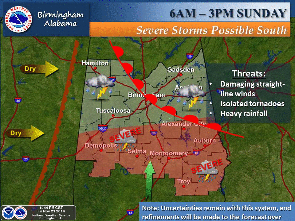
Rain amounts around one inch are likely for Birmingham, Tuscaloosa, Anniston, and Gadsden… amounts of over two inches are possible across the southern third of the state.
NEXT WEEK: The weather trends colder. A cold front Monday will bring only an outside risk of a shower, then our weather looks rain-free Tuesday through the following weekend (November 25-30). The coldest days should come on Wednesday and Thanksgiving Day, with highs in the 40s and lows in the 20s. See the Weather Xtreme video for maps, graphics, and more details.
FOOTBALL WEATHER: Very nice weather for the high school football games across North/Central Alabama tonight; some clouds around (but no rain) with temperatures falling from 53 at kickoff, into the mid to upper 40s by the final whistle.
Tomorrow is homecoming at the Capstone in Tuscaloosa, and for the football game (Alabama vs Western Carolina) that kicks off at 3:00 p.m.. the sky will become mostly cloudy during the game, but the weather should be dry. Expect a kickoff temperature near 62 degrees, falling to near 58 by the fourth quarter. Pretty comfortable, especially compared to last weekend.
Auburn will host the Samford Bulldogs Saturday evening at Jordan-Hare Stadium (6p CT kickoff)… mostly cloudy with 56 degrees at kickoff, and low 50s by the fourth quarter. There is a small risk of a shower by the fourth quarter.
WEATHER BRAINS: Don’t forget you can listen to our weekly 90 minute netcast anytime on the web, or on iTunes. This is the show all about weather featuring many familiar voices, including our meteorologists here at ABC 33/40.
CONNECT: You can find me on all of the major social networks…
Facebook
Twitter
Google Plus
Instagram
My next Weather Xtreme video will be posted early Monday morning by 7:00… Brian Peters will have the video updates tomorrow and Sunday. Enjoy the weekend!
Category: Alabama's Weather
About the Author (Author Profile)
James Spann is one of the most recognized and trusted television meteorologists in the industry. He holds the AMS CCM designation and television seals from the AMS and NWA. He is a past winner of the Broadcast Meteorologist of the Year from both professional organizations.Subscribe
If you enjoyed this article, subscribe to receive more just like it.


