

An Update on the Severe Weather Situation for Tomorrow
After a very nice late fall Saturday across Central Alabama today with highs in the upper 60s to near 70F and lots of sunshine, thin high clouds are overspreading the area this evening. The clouds are patchy, so you can still see some stars through them. Temperatures are still mild, running around 60F. But the air has a crisp feel to it with dewpoints still in the 40s.
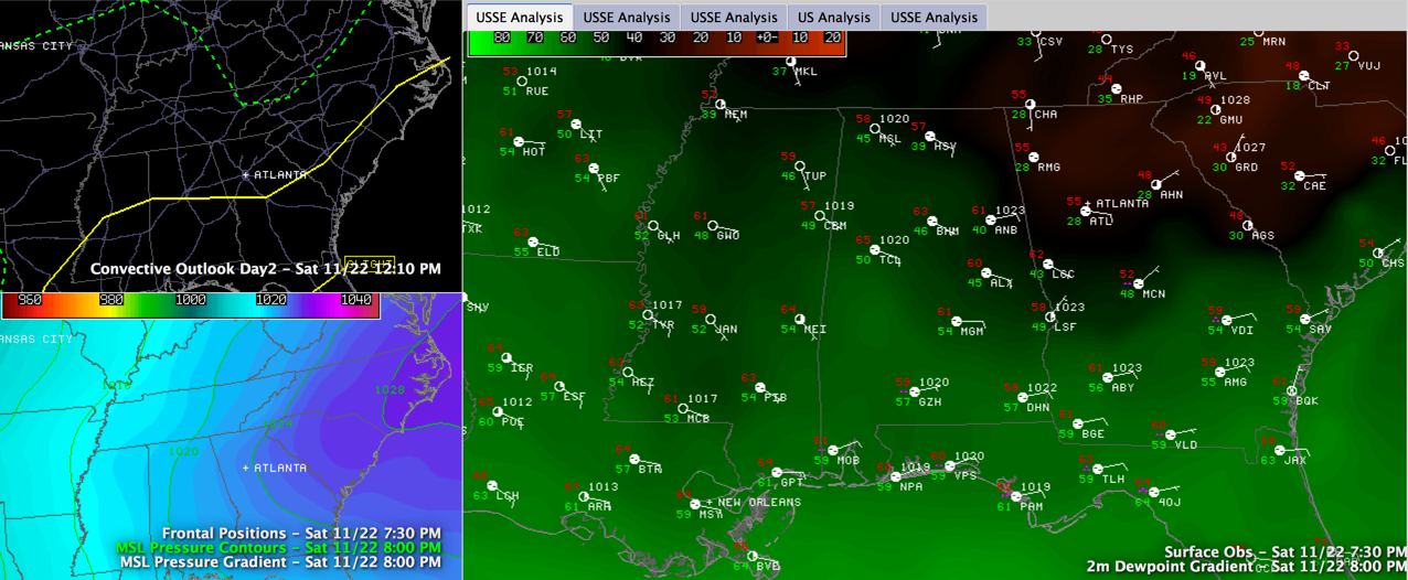
Click to enlarge
In fact, the dewpoint at Anniston is only 40F, while amazingly, the dewpoint at Atlanta is an incredible 28F. That’s really dry. The dewpoints are shown in the large graphic on the right side above.
The reason is that Alabama is still under the influence of an easterly wedge of drier air invading the state from the east thanks to high pressure off the Atlantic Coast, reinforcing the drier air. You can see the surface weatehr map in the bottom left of panel of the graphic.
The wedge will be a limiting factor in our unfolding severe weather threat for tomorrow, at least for Central Alabama.
First, let me say there is no threat for severe weather tonight across Central Alabama. The main threat will come between 10 a.m. and 4 p.m. on Sunday.
A very strong upper level disturbance is approaching Dallas tonight. That will be our primary weathermaker over the next 36 hours.
Can’t rule out patches of light rain or showers after midnight tonight through the morning hours across Central Alabama. There could be an isolated heavy shower or even a storm during the morning hours ahead of the main area of rain and storms, but this activity will be isolated.
Widespread showers and storms will enter Southwest Alabama Sunday morning and push northeast. Should reach the Birmingham area by early afternoon. These storms should be elevated, and not surface based, so their main impact will be very heavy rain and loud thunder. But, with a strong mid level wind maximum passing overhead, there could be some damaging wind reports. This will all be between 10 a.m. and 4 p.m. from southwest to northeast.
The low level helicity will be maximized during the early afternoon, so it is good that there should not be much surface based instability.
The storms should weaken as they push deeper into the more stable air.
BOTTOM LINE: There is a severe weather threat generally south of a line from Reform to Tuscaloosa to Montevallo to Goodwater. The Storm Prediction Center severe weather outlook for Sunday is shown in the top left panel of the graphic above. The main threat will be damaging winds. To the north of the slight risk area defined by the SPC, the threat lessens the further north you go. But isolated storms are still possible during the afternoon hours in places like Jasper, Cullman, Birmingham, Pell City, Gadsden and Anniston.
There is a tornado threat closer to the coast and we can’t rule out an isolated tornado with the activity lifting north, so we will be watching.
LATE AFTERNOON INTO MONDAY: Some sunshine will break out during the late afternoon as sinking air behind the disturbance clear the sky. The air will actually become more unstable, but there shouldn’t be enough lift for storms to form. There could be a few late afternoon showers though. Sunday evening should be mainly dry. The main cold front will arrive early Monday morning, quickly pushing temperatures into the 50s for the day.
Category: Alabama's Weather, Severe Weather
About the Author (Author Profile)
Bill Murray is the President of The Weather Factory. He is the site's official weather historian and a weekend forecaster. He also anchors the site's severe weather coverage. Bill Murray is the proud holder of National Weather Association Digital Seal #0001 @wxhistorianSubscribe
If you enjoyed this article, subscribe to receive more just like it.


