

Slow Weekend Warm-Up Ahead
An all new edition of the ABC 33/40 Weather Xtreme video is available in the player on the right sidebar of the blog. You can subscribe to the Weather Xtreme video on iTunes by clicking here.
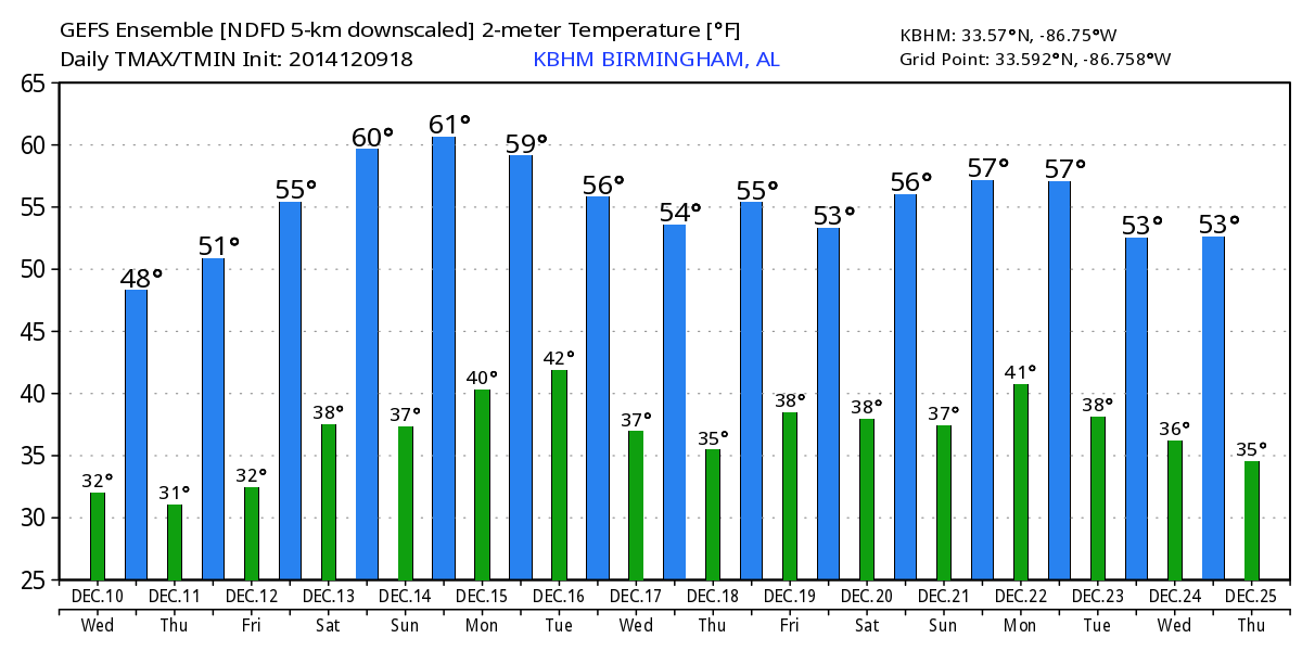
ANOTHER COLD MORNING: As cold as 18 degrees in Alabama this morning; that was the 6:00 a.m. temperature at Black Creek, just northeast of Gadsden. But, a warming trend begins later today with a good supply of sunshine as we rise into the mid to upper 50s this afternoon… that is right at seasonal averages for mid-December.
The slow warm-up continues over the weekend; the high tomorrow will be close to 60, followed by low to mid 60s Sunday. Mornings will stay chilly; many communities will see another light freeze early tomorrow morning as the weekend begins. Dry air means a sunny sky both days.
NEXT WEEK: Short wave energy will bring clouds back into the state Monday, and showers arrive late Monday afternoon over the northwest corner of the state. Looks like our best chance of showers will come from 5:00 p.m. Monday through 5:00 a.m. Tuesday… no severe weather, and probably not much thunder. And, with limited moisture rain amounts for most should be under 1/2 inch.
The sky becomes partly sunny Tuesday as drier air returns, and there is no cold air involved with this system, so the high Tuesday afternoon should be close to 60 degrees. Expect mostly sunny and pleasant weather Wednesday and Thursday with a high in the low 60s.
A dynamic weather system will bring the risk of a shower late in the week on Friday, but the main event should come the following day, on Saturday December 20. Too early to be specific, but at this point it looks like it might be a heavy rain event for Alabama with potential for strong thunderstorms.
CHRISTMAS WEEK: The Arctic Oscillation (AO) and the North Atlantic Oscillation (NAO) remain positive, which means it will be hard for bitterly cold air to invade the Deep South; temperatures for now look close to seasonal averages, with highs in the 50s and lows in the 30s generally speaking. The 06Z GFS shows potential for a rain event on Christmas Eve, but we all know in the “land of voodoo” that will probably vanish on the next run. See the Weather Xtreme video for the maps, graphics, and more details.
WEATHER BRAINS: Don’t forget you can listen to our weekly 90 minute netcast anytime on the web, or on iTunes. This is the show all about weather featuring many familiar voices, including our meteorologists here at ABC 33/40.
CONNECT: You can find me on all of the major social networks…
Facebook
Twitter
Google Plus
Instagram
I have a weather program today at Glencoe Middle School in Etowah County… then this evening I will be live from the “Bikes for Tots” event at the Walmart on Highway 150 in Hoover. The next Weather Xtreme video will be posted this afternoon by 4:00… enjoy the day…
Category: Alabama's Weather
About the Author (Author Profile)
James Spann is one of the most recognized and trusted television meteorologists in the industry. He holds the AMS CCM designation and television seals from the AMS and NWA. He is a past winner of the Broadcast Meteorologist of the Year from both professional organizations.Subscribe
If you enjoyed this article, subscribe to receive more just like it.


