

Showers Move Into Alabama Tonight
An all new edition of the ABC 33/40 Weather Xtreme video is available in the player on the right sidebar of the blog. You can subscribe to the Weather Xtreme video on iTunes by clicking here.
COLD START: Another sub-freezing morning for East Alabama; Vic Bell at Black Creek reported a low of 23 degrees early this morning; places like Anniston, Gadsden, and Fort Payne are in the upper 20s at daybreak. Most communities over the western two-thirds of the state are in the 30s.
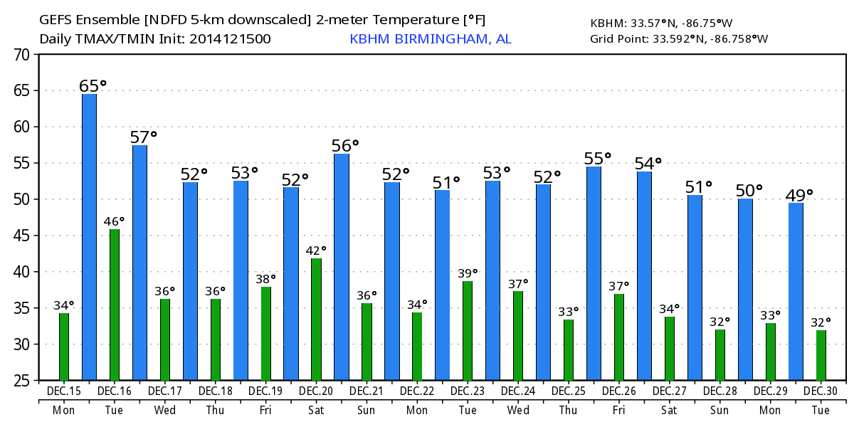
Clouds will slowly increase today ahead of a storm system across the Southern Plains, and a few showers could enter West Alabama this afternoon with temperatures rising into the 60s. The best chance of showers will come tonight, from roughly 6 p.m. through 4 a.m. tomorrow. Moisture is limited, and the air is stable, so rain amounts should be under 1/2 inch for most places. No risk of severe weather, and probably not much thunder.
TOMORROW/WEDNESDAY: The sky becomes partly sunny tomorrow as drier air works into the state. The weather will be a bit cooler, with a high in the mid to upper 50s. Wednesday will stay dry with a partly sunny sky and a high in the low to mid 50s.
LATER THIS WEEK: We will introduce the risk of a shower during the day Thursday as moisture begins to return, but rain amounts should be pretty light and spotty. A significant wave will bring the next band of organized rain into our state late Friday, Friday night, and early Saturday. The main window for the most widespread rain will come from roughly 6:00 p.m. Friday through 9:00 a.m. Saturday as a surface low moves right over North Alabama. This system will have good upper support, but at the moment it looks like the air will be too stable for any real severe weather threat.
It certainly has the potential to bring a significant amount of rain; for now we figure most of North/Central Alabama will see one inch, with potential for more in spots, especially over the northwest counties of the state.
REST OF THE WEEKEND: Drier air begins to work into the state Saturday afternoon, and we might see a little sun with a high close to 60 degrees. And, at this point, Sunday looks dry with a mix of sun and clouds and a high in the mid to upper 50s.
CHRISTMAS WEEK: The GFS shows a southern stream system that has potential to bring rain to the Gulf Coast region early in the week; best chance of wet weather Monday will be south of Montgomery, and especially near the coast. For now it looks like the rain will stay south of places like Birmingham, Anniston, Tuscaloosa, and Gadsden.
Global models are also hinting at some potential for another wet weather system on Christmas Eve; snow lovers love the 06Z GFS which hints at wintry precipitation for parts of North Alabama, but this is nothing but pure voodoo at this point. Take a few minutes and watch the Weather Xtreme video for the maps, graphics, and more details on long range ideas. Seems like a pattern change is very possible toward the end of the month, but nobody knows the details for now.
WEATHER BRAINS: Don’t forget you can listen to our weekly 90 minute netcast anytime on the web, or on iTunes. This is the show all about weather featuring many familiar voices, including our meteorologists here at ABC 33/40. We will produce this week’s show tonight at 8:30 CT… you can watch it on “James Spann 24/7” on cable systems around the state, or on the web here.
CONNECT: You can find me on all of the major social networks…
Facebook
Twitter
Google Plus
Instagram
Look for the next Weather Xtreme video here by 4:00 or so this afternoon… enjoy the day!
Category: Alabama's Weather
About the Author (Author Profile)
James Spann is one of the most recognized and trusted television meteorologists in the industry. He holds the AMS CCM designation and television seals from the AMS and NWA. He is a past winner of the Broadcast Meteorologist of the Year from both professional organizations.Subscribe
If you enjoyed this article, subscribe to receive more just like it.


